Malad City
Airport details
| Country | United States of America |
| State | Idaho |
| Region | K1 |
| Airspace | Salt Lake City Ctr |
| Municipality | Oneida County |
| Elevation | 4501ft (1372m) |
| Timezone | GMT -7 |
| Coordinates | 42.17044, -112.28931 |
| Magnetic var | |
| Type | land |
| Available since | X-Plane v10.40 |
| ICAO code | KMLD |
| IATA code | MLD |
| FAA code | MLD |
Communication
| Malad city CTAF | 122.900 |
Nearby Points of Interest:
Malad Second Ward Tabernacle
-United Presbyterian Church
-Oneida County Courthouse
-D.L. Evans Sr. Bungalow
-Jedd Jones House
-Clarkston Tithing Granary
-Franklin County Courthouse
-Matthias Cowley House
-Franklin Historic Properties
-Franklin City Hall
-Hampton's Ford Stage Stop and Barn
-Richmond Tithing Office
-Garland Carnegie Library
-Smithfield Tithing Office
-Samuel and Lana Ewing House
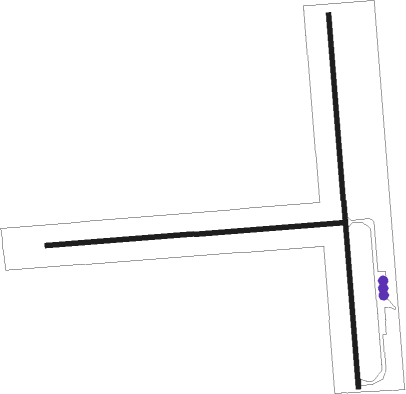
Runway info
Runway 08 / 26  | ||
| length | 1204m (3950ft) | |
| bearing | 90° / 270° | |
| width | 18m (59ft) | |
| surface | grass | |
| Runway 16 / 34 | ||
| length | 1528m (5013ft) | |
| bearing | 180° / 360° | |
| width | 18m (60ft) | |
| surface | asphalt | |
| displ threshold | 46m (151ft) / 64m (210ft) | |
Nearby beacons
| code | identifier | dist | bearing | frequency |
|---|---|---|---|---|
| MLD | MALAD CITY VOR/DME | 7.4 | 280° | 117.40 |
| LHO | BRIGHAM CITY (LOGAN) VOR/DME | 25.8 | 143° | 112.90 |
| PIH | POCATELLO VOR/DME | 45 | 333° | 112.60 |
| PI | TYHEE (POCATELLO) NDB | 48.6 | 344° | 383 |
| OGD | OGDEN VORTAC | 57.4 | 169° | 115.70 |
Disclaimer
The information on this website is not for real aviation. Use this data with the X-Plane flight simulator only! Data taken with kind consent from X-Plane 12 source code and data files. Content is subject to change without notice.