Modesto - Modesto City-county
Airport details
| Country | United States of America |
| State | California |
| Region | K2 |
| Airspace | Oakland Ctr |
| Municipality | Modesto |
| Elevation | 97ft (30m) |
| Timezone | GMT -8 |
| Coordinates | 37.62692, -120.95246 |
| Magnetic var | |
| Type | land |
| Available since | X-Plane v10.40 |
| ICAO code | KMOD |
| IATA code | MOD |
| FAA code | MOD |
Communication
| Modesto City-County ATIS | 127.700 |
| Modesto City-County CTAF | 125.300 |
| Modesto City-County UNICOM | 122.950 |
| Modesto City-County Ground Control | 121.700 |
| Modesto City-County Tower | 125.300 |
| Modesto City-County NORCAL Approach | 120.950 |
| Modesto City-County NORCAL Departure (West) | 123.850 |
| Modesto City-County NORCAL Departure (North) | 125.100 |
| Modesto City-County NORCAL Departure (East-South) | 129.950 |
Approach frequencies
| ILS-cat-I | RW28R | 111.9 | 18.00mi |
| 3° GS | RW28R | 111.9 | 18.00mi |
Nearby Points of Interest:
McHenry Mansion
-El Viejo Post Office
-John Ohm House
-Bank of Italy
-Bank of Tracy
-Tracy City Hall and Jail
-Odd Fellows Hall
-Bloss Mansion
-Old La Grange Schoolhouse
-Old Adobe Barn
-Wong K. Gew Mansion
-Tretheway Block
-United States Post Office (Stockton, California)
-Elks Building
-Honigsberger Store
-Reed's Store
-Copperopolis Armory
-Copperopolis Congregational Church
-Merced County High School
-Kaehler-Rector House
-Leggett House
-United States Post Office (Merced, California)
-Maj. George Beecher Cook House
-Thomas H. Leggett House
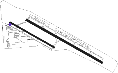
Runway info
Runway 10L / 28R  | ||
| length | 1799m (5902ft) | |
| bearing | 118° / 298° | |
| width | 46m (151ft) | |
| surface | asphalt | |
| blast zone | 64m (210ft) / 30m (98ft) | |
| Runway 10R / 28L | ||
| length | 1055m (3461ft) | |
| bearing | 118° / 298° | |
| width | 30m (98ft) | |
| surface | asphalt | |
| blast zone | 162m (531ft) / 0m (0ft) | |
Nearby beacons
| code | identifier | dist | bearing | frequency |
|---|---|---|---|---|
| MOD | MODESTO VOR/DME | 0.2 | 275° | 114.60 |
| LIN | LINDEN VOR/DME | 26.9 | 353° | 114.80 |
| LV | REIGA (LIVERMORE) NDB | 35 | 275° | 374 |
| HYP | EL NIDO (MERCED) VOR/DME | 35.9 | 126° | 114.20 |
| SJC | SAN JOSE VOR/DME | 49.6 | 256° | 114.10 |
| PXN | PANOCHE VORTAC | 55.3 | 169° | 112.60 |
| SAC | SACRAMENTO VORTAC | 56.6 | 324° | 115.20 |
| SUU | TRAVIS (FAIRFIELD) TACAN | 59.9 | 302° | 116.60 |
| SNS | SALINAS VORTAC | 65.6 | 214° | 117.30 |
Instrument approach procedures
| runway | airway (heading) | route (dist, bearing) |
|---|---|---|
| RW28R | FRA (291°) | FRA KALEI (45mi, 287°) 7500ft DLRAY (10mi, 298°) 3500ft |
| RW28R | PXN (349°) | PXN KALEI (42mi, 25°) 7500ft DLRAY (10mi, 298°) 3500ft |
| RW28R | VOLTA (3°) | VOLTA FABNA (13mi, 69°) 3500ft DLRAY (7mi, 41°) 3500ft |
| RNAV | DLRAY 3500ft ZELAT (12mi, 298°) 1800ft KMOD (6mi, 299°) 135ft (6849mi, 107°) 500ft SHELI (6855mi, 287°) 3000ft SHELI (turn) 3000ft |
Disclaimer
The information on this website is not for real aviation. Use this data with the X-Plane flight simulator only! Data taken with kind consent from X-Plane 12 source code and data files. Content is subject to change without notice.