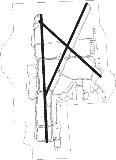
Madison - Dane County Regl
Airport details
| Country | United States of America |
| State | Wisconsin |
| Region | K5 |
| Airspace | Chicago Ctr |
| Municipality | Madison |
| Elevation | 887ft (270m) |
| Timezone | GMT -6 |
| Coordinates | 43.13988, -89.33751 |
| Magnetic var | |
| Type | land |
| Available since | X-Plane v10.40 |
| ICAO code | KMSN |
| IATA code | MSN |
| FAA code | MSN |
Communication
| Dane County Regl ATIS | 124.650 |
| Dane County Regl UNICOM | 122.950 |
| Dane County Regl CTAF | 119.300 |
| Dane County Regl MADISON Clearance DEL | 121.625 |
| Dane County Regl MADISON Ground Control | 121.900 |
| Dane County Regl MADISON Tower | 119.300 |
| Dane County Regl MADISON Approach | 120.100 |
| Dane County Regl MADISON Departure | 120.100 |
Approach frequencies
| ILS-cat-III | RW36 | 110.1 | 18.00mi |
| ILS-cat-II | RW18 | 110.1 | 18.00mi |
| ILS-cat-I | RW21 | 111.55 | 18.00mi |
| 3° GS | RW21 | 111.55 | 18.00mi |
| 3° GS | RW18 | 110.1 | 18.00mi |
| 3° GS | RW36 | 110.1 | 18.00mi |
Runway info
Nearby beacons
| code | identifier | dist | bearing | frequency |
|---|---|---|---|---|
| MSN | MADISON VORTAC | 0.3 | 336° | 108.60 |
| RYV | ROCK RIVER (WATERTOWN) NDB | 26.8 | 87° | 371 |
| DLL | DELLS (BARABOO) VORTAC | 30.9 | 314° | 117 |
| UNU | JUNEAU NDB | 32.7 | 66° | 344 |
| LNR | ROCK DME | 36 | 281° | 116.05 |
| JVL | JANESVILLE VOR/DME | 36.4 | 158° | 114.30 |
| RFD | DME | 55.2 | 171° | 110.80 |
| OS | POBER (OSHKOSH) NDB | 55.6 | 47° | 395 |
| OSH | OSHKOSH VORTAC | 61.3 | 43° | 116.75 |
| DAF | NECEDAH NDB | 62.7 | 320° | 233 |
| VOK | VOLK (CAMP DOUGLAS) TACAN | 62.7 | 311° | 110.40 |
Instrument approach procedures
| runway | airway (heading) | route (dist, bearing) |
|---|---|---|
| RW03 | WIROD (37°) | WIROD 3600ft |
| RNAV | WIROD 3600ft ZUSNA (5mi, 37°) 2700ft ZEPUD (3mi, 37°) 2600ft MIBPU (3mi, 37°) 1540ft KMSN (2mi, 36°) 909ft (5376mi, 116°) 1060ft FONUV (5370mi, 296°) 3600ft FONUV (turn) | |
| RW14 | MSN (156°) | MSN SIDCO (11mi, 308°) 3200ft SIDCO (turn) 3200ft |
| RW14 | NEGUS (101°) | NEGUS SIDCO (14mi, 83°) 3200ft |
| RW14 | WREST (172°) | WREST SIDCO (15mi, 208°) 3200ft |
| RNAV | SIDCO 3200ft UFDIM (6mi, 127°) 2500ft HIREX (3mi, 128°) 1500ft KMSN (2mi, 133°) 914ft (5376mi, 116°) 1059ft CINOT (5367mi, 296°) 3000ft CINOT (turn) | |
| RW18 | AYECO (182°) | AYECO 3000ft |
| RW18 | DLL (134°) | DLL AYECO (22mi, 115°) 3000ft |
| RW18 | RANDO (222°) | RANDO AYECO (16mi, 246°) 3000ft |
| RW18 | WREST (172°) | WREST AYECO (11mi, 161°) 3000ft |
| RNAV | AYECO 3000ft GATNE (4mi, 183°) 2700ft RUKIY (3mi, 183°) 2500ft KMSN (5mi, 180°) 916ft (5376mi, 116°) 1064ft DEKEY (5377mi, 296°) 3000ft DEKEY (turn) | |
| RW21 | FONUV (217°) | FONUV 3600ft |
| RNAV | FONUV 3600ft HEVUS (5mi, 217°) 2700ft JAPRO (3mi, 217°) 2500ft YARUT (3mi, 217°) 1540ft KMSN (3mi, 218°) 940ft (5376mi, 116°) 1087ft WIROD (5383mi, 296°) 3600ft WIROD (turn) | |
| RW32 | MSN (156°) | MSN CINOT (14mi, 127°) 3000ft CINOT (turn) 3000ft |
| RW32 | OMONE (9°) | OMONE CINOT (17mi, 53°) 3000ft |
| RW32 | WAITS (271°) | WAITS CINOT (23mi, 253°) 3000ft |
| RNAV | CINOT 3000ft NUXMU (8mi, 308°) 2600ft PEKDE (3mi, 308°) 1480ft KMSN (2mi, 303°) 918ft (5376mi, 116°) 1232ft SIDCO (5384mi, 296°) 3200ft SIDCO (turn) | |
| RW36 | DEBOW (309°) | DEBOW COBLE (20mi, 292°) 3000ft DEKEY (6mi, 295°) 3000ft |
| RW36 | DEKEY (4°) | DEKEY 3000ft |
| RW36 | JVL (338°) | JVL OFAGO (17mi, 328°) 3100ft DEKEY (9mi, 328°) 3000ft |
| RW36 | THEBO (63°) | THEBO WENAT (13mi, 113°) 3000ft DEKEY (6mi, 40°) 3000ft |
| RNAV | DEKEY 3000ft FELIL (4mi, 3°) 2700ft OZMIX (2mi, 3°) 2500ft ZIMIT (3mi, 3°) 1420ft KMSN (2mi, 8°) 920ft (5376mi, 116°) 1062ft AYECO (5376mi, 296°) 3000ft AYECO (turn) |
Disclaimer
The information on this website is not for real aviation. Use this data with the X-Plane flight simulator only! Data taken with kind consent from X-Plane 12 source code and data files. Content is subject to change without notice.

