Orange Grove - Orange Grove Nalf
Airport details
| Country | United States of America |
| State | Texas |
| Region | K4 |
| Airspace | Houston Oceanic Ctr |
| Municipality | Jim Wells County |
| Elevation | 255ft (78m) |
| Timezone | GMT -6 |
| Coordinates | 27.89682, -98.04356 |
| Magnetic var | |
| Type | land |
| Available since | X-Plane v10.40 |
| ICAO code | KNOG |
| IATA code | n/a |
| FAA code | NOG |
Communication
| Orange Grove Nalf Tower | 128.400 |
| Orange Grove Nalf KINGSVILLE Departure | 119.900 |
Approach frequencies
| ILS-cat-I | RW13 | 110.5 | 18.00mi |
| 3° GS | RW13 | 110.5 | 18.00mi |
Nearby Points of Interest:
King Ranch
-John B. Ragland Mercantile Company Building
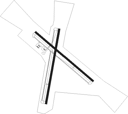
Runway info
Runway 1 / 19  | ||
| length | 2447m (8028ft) | |
| bearing | 16° / 196° | |
| width | 61m (200ft) | |
| surface | asphalt | |
| blast zone | 255m (837ft) / 255m (837ft) | |
| Runway 13 / 31 | ||
| length | 2441m (8009ft) | |
| bearing | 131° / 311° | |
| width | 61m (200ft) | |
| surface | asphalt | |
| blast zone | 255m (837ft) / 255m (837ft) | |
Nearby beacons
| code | identifier | dist | bearing | frequency |
|---|---|---|---|---|
| NOG | ORANGE GROVE TACAN | 0.1 | 148° | 133.60 |
| ALI | ALICE VOR | 9.5 | 172° | 114.50 |
| NQI | KINGSVILLE TACAN | 27 | 149° | 117.80 |
| CRP | CORPUS CHRISTI VORTAC | 31.7 | 89° | 115.50 |
| THX | THREE RIVERS VORTAC | 36.9 | 350° | 111.40 |
| NGP | TRUAX (CORPUS CHRISTI) TACAN | 41.7 | 106° | 114 |
Disclaimer
The information on this website is not for real aviation. Use this data with the X-Plane flight simulator only! Data taken with kind consent from X-Plane 12 source code and data files. Content is subject to change without notice.