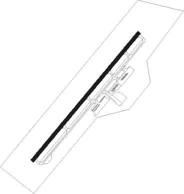
Jacksonville - Albert J Ellis Fld
Airport details
| Country | United States of America |
| State | North Carolina |
| Region | K7 |
| Airspace | Washington Ctr |
| Municipality | Onslow County |
| Elevation | 94ft (29m) |
| Timezone | GMT -5 |
| Coordinates | 34.82917, -77.61214 |
| Magnetic var | |
| Type | land |
| Available since | X-Plane v10.30 |
| ICAO code | KOAJ |
| IATA code | OAJ |
| FAA code | OAJ |
Communication
| Albert J Ellis Fld AWOS 3 | 124.475 |
| Albert J Ellis Fld CTAF/UNICOM | 123.000 |
| Albert J Ellis Fld WILMINGTON Approach/Departure | 121.400 |
Approach frequencies
| ILS-cat-I | RW05 | 108.7 | 18.00mi |
| 3° GS | RW05 | 108.7 | 18.00mi |
Nearby Points of Interest:
Venters Farm Historic District
-Bank of Onslow and Jacksonville Masonic Temple
-Eagle Nest
-Grace Episcopal Church
-Sanderson House
-Yopps Meeting House
-Palo Alto Plantation
-Foscue Plantation House
-Bryan-Bell Farm
-Bryan Lavender House
-Burgaw Depot
-Foscue and Simmons Plantations
-Sloop Point
-Robert L. Blalock House
-Baptist Parsonage
-Cedar Dell
-Lenoir County Courthouse
-Kennedy Memorial Home Historic District
-Harmony Hall
-Kinston Fire Station-City Hall
-Queen-Gordon Streets Historic District
-Kinston Baptist-White Rock Presbyterian Church
-Mitchelltown Historic District
-B. W. Canady House
-American Tobacco Company Prizery
Nearby beacons
| code | identifier | dist | bearing | frequency |
|---|---|---|---|---|
| OA | ELLAS (JACKSONVILLE) NDB | 6.5 | 230° | 261 |
| NCA | NEW RIVER TACAN | 11.2 | 125° | 115.40 |
| DIW | DIXON NDB | 17.5 | 149° | 198 |
| IS | STALS (KINSTON) NDB | 25.2 | 348° | 276 |
| EW | KAFTI (NEW BERN) NDB | 28.6 | 70° | 362 |
| GM | WILZE NDB | 31.1 | 202° | 205 |
| ILM | WILMINGTON VORTAC | 31.4 | 209° | 117 |
| EWN | NEW BERN VOR/DME | 31.5 | 67° | 113.60 |
| ISO | KINSTON VORTAC | 32.6 | 6° | 109.60 |
| GSB | SEYMOUR JOHNSON TACAN | 35.1 | 325° | 116.50 |
| NKT | CHERRY POINT TACAN | 36.5 | 84° | 112.80 |
| CTZ | CLINTON NDB | 37.9 | 281° | 412 |
| IL | AIRLI (WILMINGTON) NDB | 40.3 | 202° | 281 |
| RNW | CHOCOWINITY NDB | 47.8 | 37° | 388 |
| AQE | ALWOOD (GREENVILLE) NDB | 54 | 15° | 230 |
| JN | JURLY (SMITHFIELD) NDB | 55.6 | 308° | 263 |
Instrument approach procedures
| runway | airway (heading) | route (dist, bearing) |
|---|---|---|
| RW05 | ILM (29°) | ILM HELNA (17mi, 350°) 2100ft CUVAL (7mi, 71°) 2100ft |
| RW05 | WALLO (98°) | WALLO CUVAL (15mi, 139°) 2100ft CUVAL (turn) 2100ft |
| RNAV | CUVAL 2100ft JUNRA (6mi, 50°) 2100ft OGOYO (4mi, 50°) 680ft KOAJ (2mi, 50°) 144ft (4796mi, 114°) 900ft CUVAL (4804mi, 294°) 2100ft CUVAL (turn) | |
| RW23 | FONPO (230°) | FONPO 3100ft |
| RW23 | ISO (186°) | ISO ZAMUV (17mi, 174°) 3100ft FONPO (8mi, 129°) 3100ft |
| RNAV | FONPO 3100ft YOTUR (7mi, 230°) 2100ft ZOTUS (4mi, 230°) 740ft KOAJ (2mi, 230°) 137ft (4796mi, 114°) 291ft CUVAL (4804mi, 294°) 2100ft CUVAL (turn) |
Disclaimer
The information on this website is not for real aviation. Use this data with the X-Plane flight simulator only! Data taken with kind consent from X-Plane 12 source code and data files. Content is subject to change without notice.