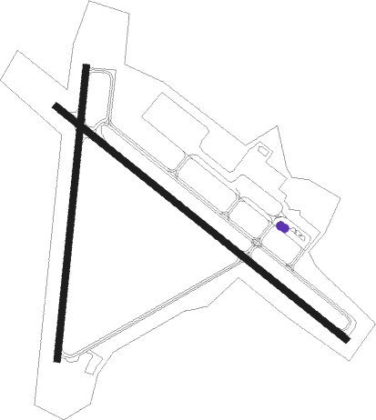
Ocean City - Ocean City Muni
Airport details
| Country | United States of America |
| State | Maryland |
| Region | K6 |
| Airspace | Washington Ctr |
| Municipality | Worcester County |
| Elevation | 11ft (3m) |
| Timezone | GMT -5 |
| Coordinates | 38.31044, -75.12397 |
| Magnetic var | |
| Type | land |
| Available since | X-Plane v10.40 |
| ICAO code | KOXB |
| IATA code | OCE |
| FAA code | OXB |
Communication
| Ocean City Muni ASOS | 119.025 |
| Ocean City Muni CTAF | 123.050 |
| Ocean City Muni PATUXENT Approach | 127.950 |
| Ocean City Muni PATUXENT Departure | 127.950 |
Approach frequencies
| LOC | RW32 | 109.15 | 18.00mi |
Nearby beacons
| code | identifier | dist | bearing | frequency |
|---|---|---|---|---|
| OX | LANDY (OCEAN CITY) NDB | 4.6 | 305° | 407 |
| SBY | SALISBURY VORTAC | 18.3 | 275° | 111.20 |
| SWL | SNOW HILL VORTAC | 22.1 | 233° | 112.40 |
| ATR | WATERLOO VOR/DME | 30.2 | 350° | 112.60 |
| SIE | SEA ISLE VORTAC | 49.5 | 22° | 114.80 |
| DOV | DOVER TACAN | 51.9 | 337° | 110 |
| ENO | SMYRNA (KENTON) VORTAC | 58.2 | 337° | 111.40 |
| CCV | CAPE CHARLES VORTAC | 71.1 | 222° | 112.20 |
Instrument approach procedures
| runway | airway (heading) | route (dist, bearing) |
|---|---|---|
| RW02 | SBY (95°) | SBY CIRAN (18mi, 125°) 2000ft CIRAN (turn) 2000ft |
| RW02 | SWL (53°) | SWL CIRAN (12mi, 69°) 2000ft |
| RNAV | CIRAN 2000ft BECAP (6mi, 38°) 1600ft KOXB (5mi, 26°) 49ft (4707mi, 117°) 420ft CIRAN (4711mi, 297°) 2000ft CIRAN (turn) | |
| RW14 | ATR (170°) | ATR PFAIR (23mi, 190°) 2000ft PFAIR (turn) 2000ft |
| RW14 | SBY (95°) | SBY PFAIR (12mi, 70°) 2000ft PFAIR (turn) 2000ft |
| RNAV | PFAIR 2000ft LANDY (6mi, 126°) 1500ft KOXB (5mi, 127°) 45ft (4707mi, 117°) 411ft PFAIR (4716mi, 297°) 2000ft PFAIR (turn) | |
| RW32 | SWL (53°) | SWL GOBYO (21mi, 81°) 2000ft FEMOD (5mi, 50°) 2000ft |
| RNAV | FEMOD 2000ft ELUCO (6mi, 307°) 1500ft KOXB (5mi, 306°) 51ft PFAIR (10mi, 307°) 2000ft PFAIR (turn) |
Disclaimer
The information on this website is not for real aviation. Use this data with the X-Plane flight simulator only! Data taken with kind consent from X-Plane 12 source code and data files. Content is subject to change without notice.

