Howell - Livingston Co Spencer J Hardy
Airport details
| Country | United States of America |
| State | Michigan |
| Region | K5 |
| Airspace | Cleveland Ctr |
| Municipality | Howell Township |
| Elevation | 960ft (293m) |
| Timezone | GMT -5 |
| Coordinates | 42.62943, -83.98219 |
| Magnetic var | |
| Type | land |
| Available since | X-Plane v10.40 |
| ICAO code | KOZW |
| IATA code | n/a |
| FAA code | OZW |
Communication
| Livingston Co Spencer J Hardy AWOS 3 | 118.875 |
| Livingston Co Spencer J Hardy CTAF/UNICOM | 123.000 |
| Livingston Co Spencer J Hardy DETROIT Approach | 127.500 |
| Livingston Co Spencer J Hardy DETROIT Departure | 127.500 |
Approach frequencies
| ILS-cat-I | RW13 | 108.55 | 18.00mi |
| 3° GS | RW13 | 108.55 | 18.00mi |
Nearby Points of Interest:
Frank J. Hecox House
-Ann Arbor Railway Howell Depot
-Howell Downtown Historic District
-William K. and Nellie (Harper) Sexton House
-Livingston County Courthouse
-August Westphal Farmstead
-Western House (Brighton, Michigan)
-William Henry and Lucinda McCaslin Farm House
-Isaac R. Middlesworth Farm House
-House at 7066 Lobdell Road
-James H. Murray House
-Stockbridge Town Hall
-Bell Road Bridge
-Bridge Street-Broad Street Historic District
-Genesee Avenue–Walker Street Historic District
-Bingham House
-Dibbleville-Fentonville Historic District
-Edwin Trump House
-Charles H. Calkins House
-Hubbard-Kesby House
-Fenton Railroad Depot
-Highland United Methodist Church
-Alonzo W. Olds House
-William Horton Farmhouse
-Dr. Henry K. Foote House
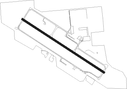
Runway info
| Runway 13 / 31 | ||
| length | 1524m (5000ft) | |
| bearing | 119° / 299° | |
| width | 30m (100ft) | |
| surface | asphalt | |
Nearby beacons
| code | identifier | dist | bearing | frequency |
|---|---|---|---|---|
| PSI | DME | 20.3 | 81° | 111 |
| SVM | SALEM VORTAC | 21.7 | 120° | 114.30 |
| FNT | FLINT VORTAC | 22.7 | 35° | 116.90 |
| JXN | DME | 30.6 | 232° | 115.45 |
| TCU | TECUMSEH NDB | 36 | 171° | 239 |
| DXO | DETROIT VOR/DME | 37 | 124° | 113.40 |
| DT | REVUP (DETROIT) NDB | 39.1 | 133° | 388 |
| CRL | CARLETON VOR/DME | 41.9 | 138° | 115.70 |
| DM | SPENC (DETROIT) NDB | 42.3 | 118° | 223 |
| ADG | ADRIAN NDB | 45.8 | 187° | 278 |
| RYS | GROSSE ILE (DETROIT) NDB | 48.5 | 123° | 419 |
| LFD | LITCHFIELD VOR/DME | 48.6 | 234° | 111.20 |
| MB | OLSTE (SAGINAW) NDB | 50.7 | 347° | 257 |
| MBS | SAGINAW VOR/DME | 54.3 | 354° | 112.90 |
| MOP | MOUNT PLEASANT VOR/DME | 68.2 | 323° | 110.60 |
Departure and arrival routes
| Transition altitude | 18000ft |
| Transition level | 18000ft |
| SID end points | distance | outbound heading | |
|---|---|---|---|
| RW13 | |||
| TRMML3 | 67mi | 16° | |
| ZETTR3 | 74mi | 76° | |
| HHOWE3 | 112mi | 99° | |
| PAVYL2 | 111mi | 103° | |
| LIDDS2 | 155mi | 119° | |
| CLVIN2 | 222mi | 183° | |
| BARII2 | 132mi | 190° | |
| SNDRS2 | 115mi | 193° | |
| CCOBB2 | 54mi | 250° | |
| KAYLN2 | 95mi | 266° | |
| MIGGY2 | 65mi | 311° | |
| RW31 | |||
| TRMML3 | 67mi | 16° | |
| ZETTR3 | 74mi | 76° | |
| HHOWE3 | 112mi | 99° | |
| PAVYL2 | 111mi | 103° | |
| LIDDS2 | 155mi | 119° | |
| CLVIN2 | 222mi | 183° | |
| BARII2 | 132mi | 190° | |
| SNDRS2 | 115mi | 193° | |
| CCOBB2 | 54mi | 250° | |
| KAYLN2 | 95mi | 266° | |
| MIGGY2 | 65mi | 311° | |
| STAR starting points | distance | inbound heading | |
|---|---|---|---|
| ALL | |||
| PETTE2 | 36.7 | 33° | |
| OKLND1 | 89.0 | 264° | |
| FOREY2 | 75.2 | 301° | |
Instrument approach procedures
| runway | airway (heading) | route (dist, bearing) |
|---|---|---|
| RW13 | FNT (215°) | FNT PIPTY (19mi, 251°) 3000ft HUCCY (6mi, 204°) 3000ft |
| RW13 | HUCCY (119°) | HUCCY 3000ft |
| RW13 | WEPPY (101°) | WEPPY HUCCY (5mi, 64°) 3000ft |
| RNAV | HUCCY 3000ft DURGY (6mi, 119°) 2500ft JIVEX (3mi, 119°) 1660ft KOZW (3mi, 119°) 1010ft (5139mi, 117°) 1162ft BROVI (5131mi, 297°) 2800ft BROVI (turn) | |
| RW31 | BROVI (299°) | BROVI 6000ft BROVI (turn) 2800ft |
| RW31 | JEKAV (271°) | JEKAV BROVI (8mi, 233°) 2800ft |
| RW31 | POVCI (334°) | POVCI BROVI (7mi, 38°) 2800ft |
| RNAV | BROVI 2800ft PODEE (6mi, 300°) 2100ft KOZW (4mi, 299°) 983ft (5139mi, 117°) 1143ft HUCCY (5148mi, 297°) 3000ft HUCCY (turn) |
Holding patterns
| STAR name | hold at | type | turn | heading* | altitude | leg | speed limit |
|---|---|---|---|---|---|---|---|
| FOREY2 | FOREY | VHF | right | 144 (324)° | DME 10.0mi | ICAO rules | |
| PETTE2 | PETTE | VHF | left | 241 (61)° | DME 10.0mi | ICAO rules | |
| RRALF3 | KILTT | VHF | right | 313 (133)° | DME 10.0mi | ICAO rules | |
| *) magnetic outbound (inbound) holding course | |||||||
Disclaimer
The information on this website is not for real aviation. Use this data with the X-Plane flight simulator only! Data taken with kind consent from X-Plane 12 source code and data files. Content is subject to change without notice.