Punta Gorda
Airport details
| Country | United States of America |
| State | Florida |
| Region | K7 |
| Airspace | Miami Oceanic Ctr |
| Municipality | Charlotte County |
| Elevation | 20ft (6m) |
| Timezone | GMT -5 |
| Coordinates | 26.91894, -81.99093 |
| Magnetic var | |
| Type | land |
| Available since | X-Plane v10.40 |
| ICAO code | KPGD |
| IATA code | PGD |
| FAA code | PGD |
Communication
| Punta Gorda ASOS | 135.675 |
| Punta Gorda CTAF | 121.000 |
| Punta Gorda UNICOM | 122.975 |
| Punta Gorda Clearance DEL | 127.050 |
| Punta Gorda GROUND | 119.550 |
| Punta Gorda TOWER | 121.000 |
| Punta Gorda FORT MYERS Approach | 125.150 |
| Punta Gorda FORT MYERS Departure | 125.150 |
Approach frequencies
| ILS-cat-I | RW04 | 109.75 | 18.00mi |
| 3° GS | RW04 | 109.75 | 18.00mi |
Nearby Points of Interest:
Villa Bianca
-Clarence L. Babcock House
-A. C. Freeman House
-Punta Gorda Atlantic Coast Line Depot
-Old First National Bank of Punta Gorda
-Mott Willis Store
-Hillsboro State Bank Building
-El Jobean Post Office and General Store
-Menge-Hansen Marine Ways
-Journey's End
-Halstead and Emily Lindsley House
-Gasparilla Inn Historic District
-Murphy-Burroughs House
-Alderman House
-Downtown Boca Grande Historic District
-Whidden's Marina
-Old Lee County Courthouse
-Boca Grande Community Center
-William H. Towles House
-Charlotte Harbor and Northern Railway Depot
-Casa Rio
-Arcadia Historic District
-Micajah T. Singleton House
-Jewett-Thompson House
-Johnson-Smith House
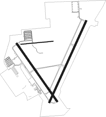
Runway info
Runway 4 / 22  | ||
| length | 2198m (7211ft) | |
| bearing | 32° / 212° | |
| width | 46m (151ft) | |
| surface | asphalt | |
| Runway 15 / 33 | ||
| length | 1738m (5702ft) | |
| bearing | 146° / 326° | |
| width | 46m (151ft) | |
| surface | asphalt | |
| displ threshold | 171m (561ft) / 0m (0ft) | |
| Runway 9 / 27 | ||
| length | 801m (2628ft) | |
| bearing | 89° / 269° | |
| width | 18m (59ft) | |
| surface | asphalt | |
| blast zone | 15m (49ft) / 0m (0ft) | |
Nearby beacons
| code | identifier | dist | bearing | frequency |
|---|---|---|---|---|
| PGD | PUNTA GORDA VOR | 0.1 | 188° | 110.20 |
| FM | CALOO (FORT MYERS) NDB | 24.2 | 174° | 341 |
| RSW | LEE COUNTY (FORT MYERS) VORTAC | 26 | 151° | 111.80 |
| LBV | LA BELLE VORTAC | 32.5 | 99° | 110.40 |
| SRQ | SARASOTA VOR/DME | 42.3 | 310° | 117 |
| CYY | CYPRESS (NAPLES) VOR/DME | 47.3 | 164° | 108.60 |
| MCF | MACDILL (TAMPA) TACAN | 63 | 331° | 111 |
| PIE | SAINT PETERSBURG VORTAC | 69.9 | 325° | 116.40 |
Departure and arrival routes
| Transition altitude | 18000ft |
| Transition level | 18000ft |
| STAR starting points | distance | inbound heading | |
|---|---|---|---|
| ALL | |||
| PIKKR7 | 37.4 | 92° | |
| LUBBR2 | 105.9 | 176° | |
Instrument approach procedures
| runway | airway (heading) | route (dist, bearing) |
|---|---|---|
| RW04 | BULOW (31°) | BULOW 2000ft |
| RW04 | RSW (331°) | RSW CUPAV (17mi, 294°) 2000ft BULOW (6mi, 342°) 2000ft |
| RW04 | VIOLA (95°) | VIOLA ZEGIS (15mi, 149°) 2000ft BULOW (6mi, 76°) 2000ft |
| RNAV | BULOW 2000ft CISTS (6mi, 32°) 1600ft YENCU (3mi, 32°) 680ft KPGD (2mi, 27°) 73ft (4977mi, 108°) 224ft DOGLE (4974mi, 288°) JOCKS (5mi, 82°) 2000ft JOCKS (turn) | |
| RW15 | APZUL (145°) | APZUL 2000ft |
| RW15 | PINTS (51°) | PINTS BRUSK (14mi, 341°) 2000ft APZUL (7mi, 62°) 2000ft |
| RW15 | ROGAN (196°) | ROGAN SACRA (9mi, 222°) 2000ft APZUL (7mi, 241°) 2000ft |
| RNAV | APZUL 2000ft UBIDY (6mi, 146°) 1600ft VICHY (3mi, 146°) 580ft KPGD (2mi, 140°) 66ft (4977mi, 108°) 272ft DODIK (4974mi, 288°) OWGAF (9mi, 198°) 2500ft OWGAF (turn) | |
| RW22 | QUNCY (251°) | QUNCY AIRVA (13mi, 281°) 2000ft |
| RW22 | ROGAN (196°) | ROGAN AIRVA (10mi, 176°) 2000ft |
| RNAV | AIRVA 2000ft DOGLE (6mi, 212°) 1600ft EGOTE (3mi, 212°) 540ft KPGD (2mi, 217°) 66ft (4977mi, 108°) 226ft BULOW (4981mi, 288°) 2000ft BULOW (turn) | |
| RW33 | RSW (331°) | RSW PETSE (15mi, 334°) 2500ft |
| RW33 | VIOLA (95°) | VIOLA OWGAF (24mi, 127°) 2500ft PETSE (7mi, 61°) 2500ft |
| RNAV | PETSE 2500ft DODIK (6mi, 326°) 1600ft FARBI (3mi, 326°) 560ft KPGD (2mi, 333°) 71ft (4977mi, 108°) 273ft APZUL (4983mi, 288°) 2000ft APZUL (turn) |
Holding patterns
| STAR name | hold at | type | turn | heading* | altitude | leg | speed limit |
|---|---|---|---|---|---|---|---|
| LUBBR2 | LUBBR | VHF | right | 4 (184)° | DME 8.0mi | ICAO rules | |
| PIKKR7 | CODGR | VHF | right | 289 (109)° | DME 11.0mi | ICAO rules | |
| PIKKR7 | OBESE | VHF | left | 5 (185)° | DME 11.0mi | ICAO rules | |
| PIKKR7 | PIKKR | VHF | right | 328 (148)° | DME 8.0mi | ICAO rules | |
| PIKKR7 | WHITL | VHF | left | 6 (186)° | DME 11.0mi | ICAO rules | |
| *) magnetic outbound (inbound) holding course | |||||||
Disclaimer
The information on this website is not for real aviation. Use this data with the X-Plane flight simulator only! Data taken with kind consent from X-Plane 12 source code and data files. Content is subject to change without notice.