Newport News - Newport News/williamsburg International
Airport details
| Country | United States of America |
| State | Virginia |
| Region | K6 |
| Airspace | Washington Ctr |
| Municipality | Newport News |
| Elevation | 41ft (12m) |
| Timezone | GMT -5 |
| Coordinates | 37.13189, -76.49297 |
| Magnetic var | |
| Type | land |
| Available since | X-Plane v10.40 |
| ICAO code | KPHF |
| IATA code | PHF |
| FAA code | PHF |
Communication
| Newport News/Williamsburg International ATIS | 128.650 |
| Newport News/Williamsburg International CTAF | 118.700 |
| Newport News/Williamsburg International UNICOM | 122.950 |
| Newport News/Williamsburg International Clearance DEL | 121.650 |
| Newport News/Williamsburg International Ground Control | 121.900 |
| Newport News/Williamsburg International Tower | 124.900 |
| Newport News/Williamsburg International NORFOLK Approach | 125.700 |
| Newport News/Williamsburg International NORFOLK Departure | 124.900 |
Approach frequencies
| LOC | RW20 | 109.3 | 18.00mi |
| ILS-cat-I | RW25 | 110.1 | 18.00mi |
| ILS-cat-I | RW07 | 110.1 | 18.00mi |
| 3° GS | RW25 | 110.1 | 18.00mi |
| 3° GS | RW07 | 110.1 | 18.00mi |
Nearby Points of Interest:
Lee's Mill Earthworks
-Lee Hall station
-Simon Reid Curtis House
-Langley Research Center
-Fort Crafford
-Sessions-Pope-Sheild House
-Little England (Gloucester, Virginia)
-Kiskiack
-Carter's Grove
-Variable Density Tunnel
-Full-Scale Tunnel
-Eight-Foot High Speed Tunnel
-Smith's Pharmacy
-Whittaker Memorial Hospital
-Pasture Point Historic District
-Scott House (Hampton, Virginia)
-Old Wythe Historic District
-Noland Company Building
-Newport News Public Library
-Hampton Downtown Historic District
-Hampton City Hall
-Medical Arts Building (Newport News, Virginia)
-First Baptist Church
-Col. Josiah Parker Family Cemetery
-Timberneck
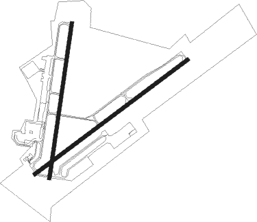
Runway info
Runway 7 / 25  | ||
| length | 2437m (7995ft) | |
| bearing | 63° / 243° | |
| width | 46m (150ft) | |
| surface | concrete | |
| Runway 2 / 20 | ||
| length | 1993m (6539ft) | |
| bearing | 16° / 196° | |
| width | 46m (150ft) | |
| surface | concrete | |
Nearby beacons
| code | identifier | dist | bearing | frequency |
|---|---|---|---|---|
| LFI | LANGLEY (HAMPTON) TACAN | 6.9 | 109° | 112.30 |
| NGU | CHAMBERS (NORFOLK) TACAN | 15.4 | 132° | 113.95 |
| ORF | NORFOLK VORTAC | 20.1 | 129° | 116.90 |
| OR | INGLE (NORFOLK) NDB | 20.9 | 140° | 329 |
| HCM | HARCUM VORTAC | 21.6 | 325° | 108.80 |
| AKQ | WAKEFIELD NDB | 25.9 | 254° | 274 |
| CCV | CAPE CHARLES VORTAC | 26.9 | 66° | 112.20 |
| NTU | OCEANA TACAN | 28.6 | 124° | 116.60 |
| NFE | CHESAPEAKE TACAN | 31.1 | 141° | 108.25 |
| HPW | HOPEWELL VORTAC | 32 | 288° | 112 |
| FKN | FRANKLIN VORTAC | 35.3 | 231° | 110.60 |
| RIC | RICHMOND VORTAC | 45.3 | 294° | 114.10 |
| CVI | COFIELD VORTAC | 49 | 207° | 114.60 |
| LLW | WOODVILLE (ELIZABETH CITY) NDB | 53 | 167° | 254 |
| ECG | ELIZABETH CITY VOR/DME | 54.6 | 160° | 112.50 |
Departure and arrival routes
| Transition altitude | 18000ft |
| Transition level | 18000ft |
| STAR starting points | distance | inbound heading | |
|---|---|---|---|
| ALL | |||
| DRONE2 | 37.1 | 16° | |
Instrument approach procedures
| runway | airway (heading) | route (dist, bearing) |
|---|---|---|
| RW02 | EVINN (321°) | EVINN NUTIY (15mi, 289°) 2300ft |
| RW02 | HCM (145°) | HCM NUTIY (31mi, 162°) 2300ft NUTIY (turn) 2300ft |
| RW02 | WAIKS (82°) | WAIKS NUTIY (26mi, 101°) 2300ft |
| RNAV | NUTIY 2300ft BCOAT (6mi, 16°) 1700ft SOLOC (3mi, 16°) 660ft KPHF (2mi, 22°) 97ft (4761mi, 116°) 241ft PANLE (4760mi, 296°) 2000ft PANLE (turn) | |
| RW07 | CVI (27°) | CVI MIDRE (37mi, 8°) 2100ft JAWES (4mi, 63°) 2000ft |
| RW07 | HCM (145°) | HCM JAWES (26mi, 180°) 2000ft JAWES (turn) 2000ft |
| RNAV | JAWES 2000ft JETIT (6mi, 63°) 2000ft KPHF (7mi, 62°) 96ft (4761mi, 116°) 243ft RIPPS (4753mi, 296°) 2500ft RIPPS (turn) | |
| RW20 | CCV (246°) | CCV PANLE (21mi, 267°) 2000ft |
| RW20 | HCM (145°) | HCM PANLE (15mi, 115°) 2000ft |
| RW20 | ORF (309°) | ORF PANLE (28mi, 331°) 2000ft PANLE (turn) 2000ft |
| RNAV | PANLE 2000ft RACOT (6mi, 196°) 1700ft ROBOY (3mi, 196°) 780ft KPHF (3mi, 191°) 84ft (4761mi, 116°) 379ft NUTIY (4762mi, 296°) 2300ft NUTIY (turn) | |
| RW25 | CCV (246°) | CCV HASBA (14mi, 249°) 2000ft |
| RW25 | HCM (145°) | HCM HASBA (25mi, 115°) 2000ft HASBA (turn) 2000ft |
| RW25 | ORF (309°) | ORF HASBA (21mi, 349°) 2000ft HASBA (turn) 2000ft |
| RNAV | HASBA 2000ft STEVE (6mi, 243°) 2000ft KPHF (7mi, 244°) 94ft (4761mi, 116°) 241ft JAWES (4770mi, 296°) 2000ft JAWES (turn) |
Holding patterns
| STAR name | hold at | type | turn | heading* | altitude | leg | speed limit |
|---|---|---|---|---|---|---|---|
| DRONE2 | DRONE | VHF | right | 233 (53)° | 1.0min timed | ICAO rules | |
| *) magnetic outbound (inbound) holding course | |||||||
Disclaimer
The information on this website is not for real aviation. Use this data with the X-Plane flight simulator only! Data taken with kind consent from X-Plane 12 source code and data files. Content is subject to change without notice.