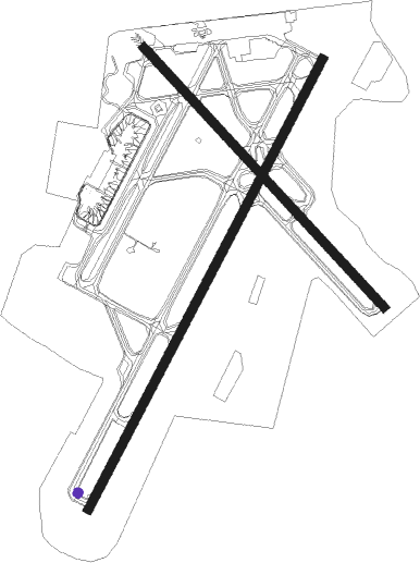
Providence - Theodore Francis Green State
Airport details
| Country | United States of America |
| State | Rhode Island |
| Region | K6 |
| Airspace | Boston Ctr |
| Municipality | Kent County |
| Elevation | 55ft (17m) |
| Timezone | GMT -5 |
| Coordinates | 41.72400, -71.42822 |
| Magnetic var | |
| Type | land |
| Available since | X-Plane v10.40 |
| ICAO code | KPVD |
| IATA code | PVD |
| FAA code | PVD |
Communication
| Theodore Francis Green State ATIS | 124.200 |
| Theodore Francis Green State CTAF | 120.700 |
| Theodore Francis Green State Clearance DEL | 126.650 |
| Theodore Francis Green State PROVIDENCE Ground Control | 121.900 |
| Theodore Francis Green State PROVIDENCE Tower | 120.700 |
| Theodore Francis Green State PROVIDENCE Approach/Departure | 123.675 |
Approach frequencies
| ILS-cat-III | RW05 | 109.3 | 18.00mi |
| ILS-cat-I | RW23 | 109.3 | 18.00mi |
| ILS-cat-I | RW34 | 111.5 | 18.00mi |
| 3° GS | RW23 | 109.3 | 18.00mi |
| 3° GS | RW05 | 109.3 | 18.00mi |
| 3° GS | RW34 | 111.5 | 18.00mi |
Nearby Points of Interest:
Rhode Island State Airport Terminal
-John R. Waterman House
-Caleb Gorton House
-Pontiac Mills
-Warwick Civic Center Historic District
-Greene-Bowen House
-Budlong Farm
-Caleb Greene House
-District Four School
-Greene-Durfee House
-John Waterman Arnold House
-Knight Estate
-Peter Greene House
-Buttonwoods Beach Historic District
-Moses Greene House
-Westcote
-Cowesett Pound
-Christopher Rhodes House
-Phillipsdale Historic District
-Arad Wood House
-Edgewood Historic District-Aberdeen Plat
-Edgewood Historic District-Taft Estate Plat
-Edgewood Historic District-Sally Greene Homestead Plats
-Edgewood Historic District–Anstis Greene Estate Plats
-Richard Wickes Greene House
Nearby beacons
| code | identifier | dist | bearing | frequency |
|---|---|---|---|---|
| PVD | PROVIDENCE VOR/DME | 0 | 284° | 115.60 |
| PUT | PUTNAM VOR/DME | 23.2 | 299° | 117.40 |
| OW | STOGE (NORWOOD) NDB | 27.2 | 37° | 397 |
| ORW | NORWICH VOR/DME | 27.5 | 254° | 110 |
| SEY | SANDY POINT (BLOCK ISLAND VOR/DME | 34 | 195° | 117.80 |
| GON | GROTON VOR/DME | 36.6 | 238° | 110.85 |
| FMH | OTIS (FALMOUTH) TACAN | 41.1 | 94° | 115.80 |
| MVY | MARTHA'S VINEYARD VOR/DME | 41.6 | 112° | 114.50 |
| BOS | BOSTON VOR/DME | 42.7 | 35° | 112.70 |
| GDM | GARDNER VOR/DME | 56.7 | 323° | 110.60 |
| HTO | HAMPTON (EAST HAMPTON) VORTAC | 62.7 | 228° | 113.60 |
Departure and arrival routes
| Transition altitude | 18000ft |
| Transition level | 18000ft |
| STAR starting points | distance | inbound heading | |
|---|---|---|---|
| ALL | |||
| JORDN2 | 45.7 | 36° | |
| RW05 | |||
| WIPOR3 | 21.8 | 58° | |
| RW16 | |||
| WIPOR3 | 21.8 | 58° | |
| RW23 | |||
| WIPOR3 | 21.8 | 58° | |
| RW34 | |||
| WIPOR3 | 21.8 | 58° | |
Instrument approach procedures
| runway | airway (heading) | route (dist, bearing) |
|---|---|---|
| RW05 | LAFAY (48°) | LAFAY KENTE (8mi, 61°) 2100ft |
| RW05 | MINNK (359°) | MINNK KENTE (13mi, 319°) 2100ft |
| RW05 | ORW (74°) | ORW KENTE (19mi, 92°) 2100ft |
| RW05 | PVD (104°) | PVD KENTE (13mi, 219°) 2100ft KENTE (turn) 2100ft |
| RNAV | KENTE 2100ft CUTSI (6mi, 40°) 2000ft FEXUX (4mi, 40°) 740ft KPVD (3mi, 39°) 106ft (4579mi, 120°) 800ft FOSTY (4590mi, 300°) 2500ft FOSTY (turn) | |
| RW16 | FOSTY (119°) | FOSTY HOKMI (3mi, 73°) 2500ft HOKMI (turn) 2500ft |
| RW16 | PVD (104°) | PVD HOKMI (11mi, 314°) 2500ft HOKMI (turn) 2500ft |
| RW16 | WOONS (161°) | WOONS HOKMI (6mi, 217°) 2500ft |
| RNAV | HOKMI 2500ft FISBO (5mi, 133°) 1800ft HUTUB (2mi, 133°) 1060ft KPVD (3mi, 136°) 104ft (4579mi, 120°) 455ft AVONN (4568mi, 300°) 2500ft AVONN (turn) | |
| RW23-Y | HOPTU (262°) | HOPTU KRANN (6mi, 310°) 2300ft FEDED (7mi, 289°) 2300ft |
| RNAV | FEDED 2300ft CUSKA (7mi, 220°) 1900ft WIVPA (4mi, 220°) 600ft KPVD (2mi, 222°) 95ft (4579mi, 120°) 1700ft FOSTY (4590mi, 300°) 2500ft FOSTY (turn) | |
| RW23-Z | FEDED (220°) | FEDED IDEAR (5mi, 220°) 2300ft HSBRO (3mi, 220°) 1400ft |
| RW23-Z | HHIGH (286°) | HHIGH 5000ft NABAH (4mi, 40°) 3900ft HSBRO (5mi, 295°) 1400ft |
| RW23-Z | JEEET (152°) | JEEET COFIE (3mi, 91°) 3000ft HSBRO (4mi, 144°) 1400ft |
| RW23-Z | SEABE (123°) | SEABE 5000ft NOSUH (4mi, 40°) 3800ft COFIE (2mi, 68°) 3000ft HSBRO (4mi, 144°) 1400ft |
| RNAV | HSBRO 1400ft KPVD (5mi, 221°) 95ft WIKIT (5mi, 219°) STUFY (7mi, 281°) FOSTY (10mi, 357°) 2500ft FOSTY (turn) | |
| RW34 | INNDY (262°) | INNDY BRAGA (9mi, 186°) 3000ft HOBET (7mi, 245°) 2100ft |
| RW34 | WACKY (48°) | WACKY JTOWN (24mi, 75°) 3000ft HOBET (7mi, 53°) 2100ft |
| RNAV | HOBET 2100ft BEVIN (7mi, 314°) 1900ft ALLEY (4mi, 313°) 560ft KPVD (2mi, 309°) 86ft (4579mi, 120°) 330ft KUNDE (4582mi, 300°) FOSTY (9mi, 294°) 2500ft FOSTY (turn) |
Disclaimer
The information on this website is not for real aviation. Use this data with the X-Plane flight simulator only! Data taken with kind consent from X-Plane 12 source code and data files. Content is subject to change without notice.

