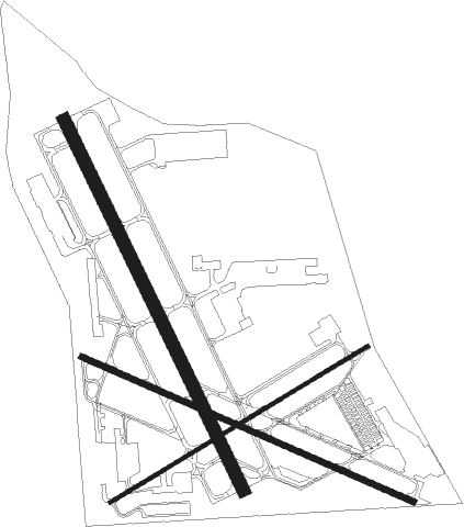
Chicago/prospect Heights/wheeling - Chicago Executive
Airport details
| Country | United States of America |
| State | Illinois |
| Region | K5 |
| Airspace | Chicago Ctr |
| Municipality | Prospect Heights |
| Elevation | 645ft (197m) |
| Timezone | GMT -6 |
| Coordinates | 42.11428, -87.90153 |
| Magnetic var | |
| Type | land |
| Available since | X-Plane v10.40 |
| ICAO code | KPWK |
| IATA code | PWK |
| FAA code | PWK |
Communication
| Chicago Executive ATIS | 124.200 |
| Chicago Executive Clearance DEL | 124.700 |
| Chicago Executive Ground Control | 121.700 |
| Chicago Executive Tower | 119.900 |
| Chicago Executive CHICAGO Approach | 120.550 |
| Chicago Executive CHICAGO Departure | 120.550 |
Approach frequencies
| ILS-cat-I | RW16 | 109.75 | 18.00mi |
| 3° GS | RW16 | 109.75 | 18.00mi |
Nearby Points of Interest:
Wheeler-Magnus Round Barn
-Nathaniel Moore Banta House
-Muller House
-Buffalo Creek Bridge
-Richard Churchill House
-George Clayson House
-Henry Dubin House
-Mrs. Frank Geyso Houses
-Charles H. Patten House
-Haerman Lanzl House
-Humer Building
-Willits House
-Ravine Bluffs Development
-Harold Florsheim House
-Rosewood Park
-George Pick House
-George Madison Millard House
-Maple Avenue/Maple Lane Historic District
-Sylvester Millard House
-Lichtstern House
-Mary W. Adams House
-William A. Glasner House
-Granville-Mott House
-John Taylor Snite House
-Robert P. Lamont House
Runway info
Nearby beacons
| code | identifier | dist | bearing | frequency |
|---|---|---|---|---|
| OBK | NORTHBROOK VOR/DME | 6.8 | 335° | 113 |
| GCO | DME | 7.2 | 180° | 108.25 |
| UG | WAUKE (CHICAGO/WAUKEGAN) NDB | 21.4 | 16° | 379 |
| DPA | DUPAGE (CHICAGO) VOR/DME | 24.1 | 243° | 108.40 |
| MX | KEDZI (CHICAGO) NDB | 24.3 | 150° | 248 |
| ENW | DME | 29.1 | 356° | 109.20 |
| RA | PASER (RACINE) NDB | 34.1 | 0° | 206 |
| BUU | (BURLINGTON) DME | 38.8 | 325° | 114.50 |
| JOT | JOLIET VOR/DME | 38.8 | 216° | 112.30 |
| CGT | CHICAGO HEIGHTS VORTAC | 39.1 | 151° | 114.20 |
| HRK | (RACINE) DME | 39.1 | 8° | 117.70 |
| GY | GARIE (GARY) NDB | 41.4 | 133° | 236 |
| EON | PEOTONE VORTAC | 50.9 | 173° | 113.20 |
| LJT | (MILWAUKEE) DME | 60 | 352° | 115.65 |
| DTG | DWIGHT NDB | 63.5 | 209° | 344 |
Departure and arrival routes
| Transition altitude | 18000ft |
| Transition level | 18000ft |
| SID end points | distance | outbound heading | |
|---|---|---|---|
| RW12 | |||
| MONKZ5 | 183mi | 160° | |
| JORJO5 | 93mi | 190° | |
| RW16 | |||
| MONKZ5 | 183mi | 160° | |
| JORJO5 | 93mi | 190° | |
| RW30 | |||
| MONKZ5 | 183mi | 160° | |
| JORJO5 | 93mi | 190° | |
| RW34 | |||
| MONKZ5 | 183mi | 160° | |
| JORJO5 | 93mi | 190° | |
Instrument approach procedures
| runway | airway (heading) | route (dist, bearing) |
|---|---|---|
| RW16 | FILLZ (117°) | FILLZ HIGUH (8mi, 74°) 2500ft |
| RW16 | HIGUH (152°) | HIGUH 2500ft |
| RW16 | OYFAM (196°) | OYFAM HIGUH (8mi, 254°) 2500ft |
| RNAV | HIGUH 2500ft PAMME (6mi, 152°) 2300ft FUGIO (3mi, 152°) 1320ft KPWK (3mi, 151°) 695ft (5312mi, 116°) 1200ft DEERE (5299mi, 296°) 2100ft DEERE (turn) |
Disclaimer
The information on this website is not for real aviation. Use this data with the X-Plane flight simulator only! Data taken with kind consent from X-Plane 12 source code and data files. Content is subject to change without notice.

