Racine - Batten Intl
Airport details
| Country | United States of America |
| State | Wisconsin |
| Region | K5 |
| Airspace | Chicago Ctr |
| Municipality | Racine |
| Elevation | 671ft (205m) |
| Timezone | GMT -6 |
| Coordinates | 42.76117, -87.81392 |
| Magnetic var | |
| Type | land |
| Available since | X-Plane v10.40 |
| ICAO code | KRAC |
| IATA code | RAC |
| FAA code | RAC |
Communication
| Batten Intl CTAF/UNICOM | 123.075 |
| Batten Intl MILWAUKEE Approach/Departure | 120.150 |
Approach frequencies
| ILS-cat-I | RW04 | 108.7 | 18.00mi |
| 3° GS | RW04 | 108.7 | 18.00mi |
Nearby Points of Interest:
Lincoln School
-No. 4 Engine House
-Karel Jonas House
-Racine Depot
-Hansen House (Racine, Wisconsin)
-McClurg Building
-Chauncey Hall Building
-Old Main Street Historic District
-Rickeman Grocery Building
-Kaiser's
-Mitchell Lewis Building
-Badger Building
-St. Luke's Episcopal Church, Chapel, Guildhall, and Rectory
-Racine Elks Club, Lodge No. 252
-Racine County Courthouse
-George Bray Neighborhood Center
-Memorial Hall
-Uptown Theater
-George Murray House
-Eli R. Cooley House
-Chauncey Hall House
-Johnson Wax Headquarters
-Thomas P. Hardy House
-Racine College
-South Milwaukee Post Office
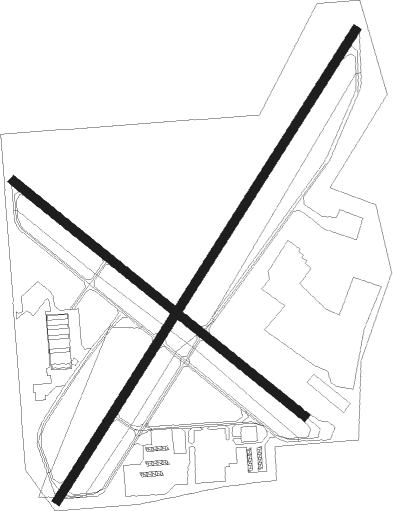
Runway info
Runway 4 / 22  | ||
| length | 2006m (6581ft) | |
| bearing | 46° / 226° | |
| width | 30m (100ft) | |
| surface | concrete | |
| displ threshold | 224m (735ft) / 119m (390ft) | |
| Runway 14 / 32 | ||
| length | 1347m (4419ft) | |
| bearing | 125° / 305° | |
| width | 30m (100ft) | |
| surface | asphalt | |
| displ threshold | 246m (807ft) / 0m (0ft) | |
Nearby beacons
| code | identifier | dist | bearing | frequency |
|---|---|---|---|---|
| HRK | (RACINE) DME | 0 | 321° | 117.70 |
| RA | PASER (RACINE) NDB | 6 | 227° | 206 |
| ENW | DME | 11 | 216° | 109.20 |
| UG | WAUKE (CHICAGO/WAUKEGAN) NDB | 17.8 | 178° | 379 |
| BUU | (BURLINGTON) DME | 21.9 | 262° | 114.50 |
| LJT | (MILWAUKEE) DME | 23.1 | 327° | 115.65 |
| BAE | BADGER (MILWAUKEE) VOR/DME | 29.7 | 307° | 116.40 |
| OBK | NORTHBROOK VOR/DME | 32.9 | 194° | 113 |
| BJB | WEST BEND VOR | 41.9 | 335° | 109.80 |
| GCO | DME | 46.2 | 187° | 108.25 |
| RYV | ROCK RIVER (WATERTOWN) NDB | 47 | 294° | 371 |
| UNU | JUNEAU NDB | 55.9 | 307° | 344 |
| DPA | DUPAGE (CHICAGO) VOR/DME | 57.4 | 212° | 108.40 |
Departure and arrival routes
| Transition altitude | 18000ft |
| Transition level | 18000ft |
| SID end points | distance | outbound heading | |
|---|---|---|---|
| ALL | |||
| UECKR6 | 49mi | 156° | |
| ACCRA5 | 51mi | 194° | |
| STAR starting points | distance | inbound heading | |
|---|---|---|---|
| ALL | |||
| GOPAC2 | 26.7 | 95° | |
Instrument approach procedures
| runway | airway (heading) | route (dist, bearing) |
|---|---|---|
| RW04 | BRAVE (278°) | BRAVE PASQO (26mi, 256°) 2600ft JENFO (4mi, 299°) 2600ft |
| RW04 | VEENA (83°) | VEENA JENFO (16mi, 108°) 2600ft |
| RNAV | JENFO 2600ft UCLID (6mi, 45°) 2600ft KRAC (6mi, 45°) 713ft (5309mi, 116°) 988ft PUYAF (5306mi, 296°) MOXUE (9mi, 119°) PASQO (18mi, 241°) 2600ft PASQO (turn) | |
| RW22 | BRAVE (278°) | BRAVE SAXON (19mi, 305°) 2300ft SAXON (turn) 2300ft |
| RNAV | SAXON 2300ft PUYAF (6mi, 226°) 2300ft KRAC (5mi, 226°) 721ft (5309mi, 116°) 949ft UCLID (5312mi, 296°) VEENA (18mi, 274°) 3000ft VEENA (turn) | |
| RW32 | BRAVE (278°) | BRAVE VOFGO (13mi, 256°) 2300ft |
| RW32 | OBK (14°) | OBK IGFIR (24mi, 35°) 2300ft VOFGO (5mi, 52°) 2300ft |
| RNAV | VOFGO 2300ft SAYMU (6mi, 305°) 2300ft KRAC (5mi, 305°) 698ft (5309mi, 116°) 1060ft CIRIP (5311mi, 296°) VEENA (20mi, 258°) 3000ft VEENA (turn) |
Holding patterns
| STAR name | hold at | type | turn | heading* | altitude | leg | speed limit |
|---|---|---|---|---|---|---|---|
| GOPAC2 | LEEDN | VHF | right | 181 (1)° | DME 10.0mi | ICAO rules | |
| GOPAC2 | ZOWRO | VHF | right | 273 (93)° | DME 10.0mi | ICAO rules | |
| *) magnetic outbound (inbound) holding course | |||||||
Disclaimer
The information on this website is not for real aviation. Use this data with the X-Plane flight simulator only! Data taken with kind consent from X-Plane 12 source code and data files. Content is subject to change without notice.