Redding - Redding Muni
Airport details
| Country | United States of America |
| State | California |
| Region | K2 |
| Airspace | Oakland Ctr |
| Municipality | Redding |
| Elevation | 501ft (153m) |
| Timezone | GMT -8 |
| Coordinates | 40.50897, -122.29339 |
| Magnetic var | |
| Type | land |
| Available since | X-Plane v10.40 |
| ICAO code | KRDD |
| IATA code | RDD |
| FAA code | RDD |
Communication
| Redding Muni ATIS | 124.100 |
| Redding Muni CTAF | 119.800 |
| Redding Muni UNICOM | 122.950 |
| Redding Muni GROUND | 121.700 |
| Redding Muni TOWER | 119.800 |
| Redding Muni OAKLAND ApproachROACH | 132.200 |
| Redding Muni OAKLAND DepartureARTURE | 132.200 |
Approach frequencies
| ILS-cat-I | RW34 | 108.7 | 18.00mi |
| 3° GS | RW34 | 108.7 | 18.00mi |
Nearby Points of Interest:
Edward Frisbie House
-Cottonwood Historic District
-Reading Adobe Site
-Oconee Hill Cemetery
-Lake Shasta Caverns
-Old Bank of America Building
-Odd Fellows Building
-Saint Mary's Parish
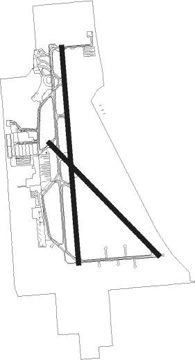
Runway info
Runway 16 / 34  | ||
| length | 2138m (7014ft) | |
| bearing | 180° / 0° | |
| width | 46m (150ft) | |
| surface | asphalt | |
| blast zone | 60m (197ft) / 61m (200ft) | |
| Runway 12 / 30 | ||
| length | 1544m (5066ft) | |
| bearing | 132° / 312° | |
| width | 46m (150ft) | |
| surface | asphalt | |
| blast zone | 61m (200ft) / 37m (121ft) | |
Nearby beacons
| code | identifier | dist | bearing | frequency |
|---|---|---|---|---|
| RDD | REDDING VOR/DME | 0.2 | 159° | 108.40 |
| RBL | RED BLUFF VORTAC | 24.7 | 172° | 115.70 |
| FJS | FORT JONES VOR/DME | 61 | 331° | 109.60 |
Departure and arrival routes
| Transition altitude | 18000ft |
| Transition level | 18000ft |
| SID end points | distance | outbound heading | |
|---|---|---|---|
| RW12 | |||
| HOMAN3 | 25mi | 172° | |
| KENDL4, KREST3 | 26mi | 242° | |
| RW16 | |||
| HOMAN3 | 25mi | 172° | |
| KENDL4, KREST3 | 26mi | 242° | |
| RW30 | |||
| HOMAN3 | 25mi | 172° | |
| KENDL4, KREST3 | 26mi | 242° | |
| RW34 | |||
| HOMAN3 | 25mi | 172° | |
| KENDL4, KREST3 | 26mi | 242° | |
Instrument approach procedures
| runway | airway (heading) | route (dist, bearing) |
|---|---|---|
| RW16 | SAVOE (143°) | SAVOE SENNE (11mi, 114°) 7000ft WARSU (6mi, 114°) 5500ft |
| RNAV | WARSU 5500ft MAHCU (4mi, 180°) 4800ft VOIDS (3mi, 180°) 3800ft USYEK (5mi, 180°) 1860ft KRDD (4mi, 179°) 560ft (6845mi, 108°) 755ft UKDOW (6850mi, 288°) 3000ft UKDOW (turn) | |
| RW34 | BEIRA (91°) | BEIRA UKDOW (14mi, 153°) 3000ft UKDOW (turn) 3000ft |
| RW34 | HOMAN (302°) | HOMAN UKDOW (10mi, 235°) 3400ft UKDOW (turn) 3000ft |
| RW34 | RBL (352°) | RBL UKDOW (12mi, 343°) 3000ft |
| RW34 | TOMAD (62°) | TOMAD EVEMY (13mi, 83°) 5000ft UKDOW (9mi, 90°) 3000ft |
| RNAV | UKDOW 3000ft LASSN (6mi, 0°) 2700ft CUYAP (5mi, 0°) 1260ft KRDD (3mi, 2°) 542ft (6845mi, 108°) 1700ft ITMOR (6833mi, 288°) 5000ft ITMOR (turn) 5000ft |
Disclaimer
The information on this website is not for real aviation. Use this data with the X-Plane flight simulator only! Data taken with kind consent from X-Plane 12 source code and data files. Content is subject to change without notice.