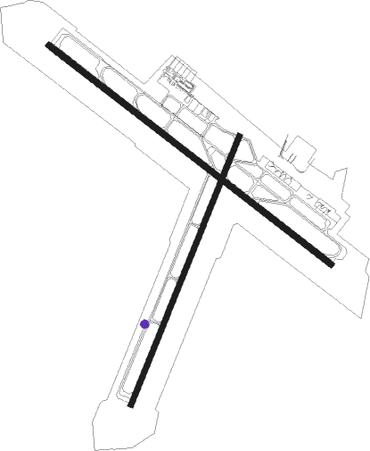
Rochester - Rochester Intl
Airport details
| Country | United States of America |
| State | Minnesota |
| Region | K3 |
| Airspace | Minneapolis Ctr |
| Municipality | Rochester |
| Elevation | 1314ft (401m) |
| Timezone | GMT -6 |
| Coordinates | 43.90828, -92.50003 |
| Magnetic var | |
| Type | land |
| Available since | X-Plane v10.40 |
| ICAO code | KRST |
| IATA code | RST |
| FAA code | RST |
Communication
| Rochester Intl ATIS | 120.500 |
| Rochester Intl CTAF | 118.300 |
| Rochester Intl UNICOM | 122.950 |
| Rochester Intl Ground Control | 121.900 |
| Rochester Intl Tower | 118.300 |
| Rochester Intl Approach/Departure | 119.800 |
Approach frequencies
| ILS-cat-II | RW31 | 108.5 | 18.00mi |
| ILS-cat-I | RW13 | 109.1 | 18.00mi |
| 3° GS | RW13 | 109.1 | 18.00mi |
| 3° GS | RW31 | 108.5 | 18.00mi |
Nearby Points of Interest:
Pleasant Grove Masonic Lodge
-George Stoppel Farmstead
-Pill Hill, Rochester, Minnesota
-Dr. William J. Mayo House
-Conley–Maass–Downs Building
-Ole Carlson House
-Exchange State Bank
-Grand Army of the Republic Hall
-Kasson Municipal Building
-Kasson Public School
-Viola Cooperative Creamery
-Spring Valley Methodist Episcopal Church
-George Haven House
-Chatfield Public Library
-Ellen Lovell House
-Mantorville
-Perry Nelson House
-Trinity Episcopal Church
-Whitewater Avenue Commercial Historic District
-Forestville
-Pietenpol Workshop and Garage
-Whitewater State Park CCC/WPA/Rustic Style Historic Resources
-Swedish Evangelical Lutheran Church
-Walnut Street Bridge
-Zumbro Parkway Bridge
Nearby beacons
| code | identifier | dist | bearing | frequency |
|---|---|---|---|---|
| RST | ROCHESTER VOR/DME | 8.6 | 218° | 112 |
| JAY | AUSTIN VOR/DME | 26.9 | 232° | 108.20 |
| OW | TONNA (OWATONNA) NDB | 30 | 284° | 379 |
| AEL | ALBERT LEA VOR/DME | 40.1 | 255° | 109.80 |
| FOW | HALFWAY (MORRISTOWN) VOR/DME | 41.5 | 289° | 111.20 |
| RG | REGUE (RED WING) NDB | 41.8 | 348° | 274 |
| IY | CHUKK (CHARLES CITY) NDB | 47.5 | 196° | 417 |
| FGT | FARMINGTON VORTAC | 52.3 | 317° | 115.70 |
| UKN | DME | 56.3 | 123° | 116.60 |
| MCW | MASON CITY VOR/DME | 60.7 | 226° | 114.90 |
| MC | SURFF (MASON CITY) NDB | 62.7 | 224° | 348 |
| MSP | MINNEAPOLIS VOR/DME | 67.2 | 323° | 115.30 |
| FCM | FLYING CLOUD (MINNEAPOLIS VOR/DME | 68.3 | 314° | 117.70 |
Instrument approach procedures
| runway | airway (heading) | route (dist, bearing) |
|---|---|---|
| RW02 | EMORE (303°) | EMORE OMAXE (13mi, 261°) 3600ft NIDLE (7mi, 290°) 3600ft |
| RW02 | NIDLE (34°) | NIDLE 3600ft |
| RW02 | ZADLA (66°) | ZADLA NIDLE (8mi, 110°) 3600ft |
| RNAV | NIDLE 3600ft LERPE (7mi, 34°) 3000ft JORTU (3mi, 34°) 1920ft KRST (3mi, 32°) 1362ft (5513mi, 115°) 1567ft BOCAG (5506mi, 296°) 3400ft BOCAG (turn) 4800ft | |
| RW13 | CORDY (123°) | CORDY HEBAS (8mi, 122°) 3000ft |
| RW13 | EGUPE (95°) | EGUPE HEBAS (8mi, 51°) 3000ft |
| RW13 | FISIN (190°) | FISIN HEBAS (15mi, 231°) 3000ft |
| RNAV | HEBAS 3000ft HUPAP (6mi, 123°) 2600ft KRST (5mi, 125°) 1321ft (5513mi, 115°) 1530ft POKYI (5510mi, 295°) RST (9mi, 247°) 2900ft RST (turn) | |
| RW20 | CORDY (123°) | CORDY COLOG (15mi, 81°) 3000ft BOCAG (7mi, 110°) 3000ft |
| RW20 | RST (38°) | RST BOCAG (23mi, 36°) 3000ft BOCAG (turn) 3000ft |
| RNAV | BOCAG 3000ft AYUGI (9mi, 215°) 3000ft KRST (6mi, 216°) 1332ft (5513mi, 115°) 1555ft LERPE (5516mi, 295°) RST (3mi, 227°) 3000ft RST (turn) | |
| RW31 | DLANY (279°) | DLANY ZUTEL (10mi, 254°) 2900ft |
| RW31 | EMORE (303°) | EMORE ZUTEL (7mi, 303°) 2900ft |
| RW31 | GABDE (324°) | GABDE ZUTEL (8mi, 4°) 2900ft |
| RNAV | ZUTEL 2900ft MINGO (7mi, 303°) 2800ft JEDUG (2mi, 303°) 2100ft KRST (3mi, 300°) 1360ft (5513mi, 115°) 1504ft CORDY (5527mi, 295°) 3000ft CORDY (turn) |
Disclaimer
The information on this website is not for real aviation. Use this data with the X-Plane flight simulator only! Data taken with kind consent from X-Plane 12 source code and data files. Content is subject to change without notice.

