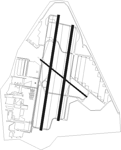
Tulsa - Richard Lloyd Jones Jr
Airport details
| Country | United States of America |
| State | Oklahoma |
| Region | K4 |
| Airspace | Kansas City Ctr |
| Municipality | Tulsa |
| Elevation | 638ft (194m) |
| Timezone | GMT -6 |
| Coordinates | 36.03868, -95.98821 |
| Magnetic var | |
| Type | land |
| Available since | X-Plane v10.40 |
| ICAO code | KRVS |
| IATA code | RVS |
| FAA code | RVS |
Communication
| Richard Lloyd Jones Jr ATIS | 126.500 |
| Richard Lloyd Jones Jr UNICOM | 122.950 |
| Richard Lloyd Jones Jr CTAF | 120.300 |
| Richard Lloyd Jones Jr Clearance DEL | 124.500 |
| Richard Lloyd Jones Jr Ground Control | 121.700 |
| Richard Lloyd Jones Jr RIVERSIDE Tower | 119.200 |
| Richard Lloyd Jones Jr RIVERSIDE Tower | 120.300 |
| Richard Lloyd Jones Jr TULSA Approach/Departure | 119.850 |
| Richard Lloyd Jones Jr TULSA Approach/Departure | 134.700 |
Approach frequencies
| ILS-cat-I | RW01L | 109.95 | 18.00mi |
| 3° GS | RW01L | 109.95 | 18.00mi |
Nearby Points of Interest:
Riverside Studio
-Westhope
-Harwelden Mansion
-Creek Council Oak Tree
-James Alexander Veasey House
-John Frank House
-Cities Service Station No. 8
-McBirney Mansion
-Clinton–Hardy House
-Oklahoma Natural Gas Company Building
-Tulsa Fire Alarm Building
-Petroleum Building
-Philcade Building
-Philtower Building
-Mayo Building
-Mid-Continent Tower
-United States Post Office and Courthouse
-Sinclair Service Station
-The Church Studio
-Dawson School
-First Presbyterian Church
-Texaco Service Station
-First Baptist Central Church
-Eastside Baptist Church
-Mullendore Mansion
Runway info
Nearby beacons
| code | identifier | dist | bearing | frequency |
|---|---|---|---|---|
| TU | OILLR (TULSA) NDB | 5.9 | 59° | 338 |
| GNP | (TULSA) DME | 7.1 | 171° | 110.60 |
| TUL | TULSA VORTAC | 13.5 | 52° | 114.40 |
| OK | PRESO (OKMULGEE) NDB | 17.1 | 172° | 388 |
| OKM | OKMULGEE VOR/DME | 21.5 | 161° | 114.90 |
| HET | HENRYETTA NDB | 38.1 | 182° | 267 |
| BVO | BARTLESVILLE VOR/DME | 47.8 | 358° | 117.90 |
| BV | DEWIE (BARTLESVILLE) NDB | 48.1 | 358° | 201 |
| SRE | SEMINOLE NDB | 56.9 | 222° | 278 |
Departure and arrival routes
| Transition altitude | 18000ft |
| Transition level | 18000ft |
| SID end points | distance | outbound heading | |
|---|---|---|---|
| RW01 (ALL) | |||
| TUL9 | 12mi | 316° | |
| RW13 | |||
| TUL9 | 12mi | 316° | |
| RW19 (ALL) | |||
| TUL9 | 12mi | 316° | |
| RW31 | |||
| TUL9 | 12mi | 316° | |
| STAR starting points | distance | inbound heading | |
|---|---|---|---|
| ALL | |||
| VINTA3 | 52.5 | 231° | |
Instrument approach procedures
| runway | airway (heading) | route (dist, bearing) |
|---|---|---|
| RW01L | INHOF (16°) | INHOF 2800ft |
| RNAV | INHOF 2800ft ZEBEK (6mi, 16°) 2500ft JALIP (3mi, 16°) 1540ft KRVS (3mi, 14°) 662ft (5696mi, 111°) 1100ft KEVIL (5709mi, 291°) 2600ft KEVIL (turn) | |
| RW19R | STEBB (164°) | STEBB HAXED (7mi, 146°) 2800ft |
| RNAV | HAXED 2800ft WUXIT (6mi, 165°) 2000ft KRVS (4mi, 198°) 681ft (5696mi, 111°) 1038ft INHOF (5699mi, 290°) 2800ft INHOF (turn) |
Disclaimer
The information on this website is not for real aviation. Use this data with the X-Plane flight simulator only! Data taken with kind consent from X-Plane 12 source code and data files. Content is subject to change without notice.

