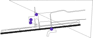
Williamson/sodus - Williamson Sodus
Airport details
| Country | United States of America |
| State | New York |
| Region | K6 |
| Airspace | Cleveland Ctr |
| Municipality | Town of Sodus |
| Elevation | 422ft (129m) |
| Timezone | GMT -5 |
| Coordinates | 43.23461, -77.11947 |
| Magnetic var | |
| Type | land |
| Available since | X-Plane v10.40 |
| ICAO code | KSDC |
| IATA code | SDC |
| FAA code | SDC |
Communication
| WILLIAMSON SODUS CTAF/UNICOM | 122.800 |
| WILLIAMSON SODUS ROCHESTER Approach/Departure | 119.550 |
Nearby Points of Interest:
Pultneyville Historic District
-Gates Hall and Pultneyville Public Square
-Preston-Gaylord Cobblestone Farmhouse
-St. Peter
-Wallington Cobblestone Schoolhouse District No. 8
-Walling Cobblestone Tavern
-Red Brick Church
-Ezra T. Phelps Farm Complex
-S.S.S. Lotus
-Zurich Bog
-Alasa Farms
-Brick Church Corners
-Market Street Historic District
-East Main Street Commercial Historic District
-Palmyra Village Historic District
-Jackson-Perkins House
-United States Post Office
-Grace Episcopal Church Complex
-Broad Street-Water Street Historic District
-Charles Bullis House
-Wolcott Square Historic District
-William C. Jayne House
-George G. Mason House
-Stephen Phelps House
Runway info
| Runway 10 / 28 | ||
| length | 1160m (3806ft) | |
| bearing | 89° / 269° | |
| width | 18m (60ft) | |
| surface | asphalt | |
Nearby beacons
| code | identifier | dist | bearing | frequency |
|---|---|---|---|---|
| ROC | ROCHESTER VOR/DME | 25.2 | 258° | 110 |
| PYA | PENN YAN NDB | 35.5 | 174° | 260 |
| FZ | FALLN (FULTON) NDB | 35.7 | 86° | 220 |
| GEE | GENESEO VOR/DME | 36 | 237° | 108.20 |
| SYR | SYRACUSE VORTAC | 40.3 | 95° | 117 |
| ITH | DME | 53 | 138° | 111.80 |
| ZZR | SEVERN (TRENTON) NDB | 53.8 | 328° | 317 |
| UTR | TRENTON TACAN | 56.1 | 335° | 109.70 |
| IT | VRNAH (ITHACA) NDB | 58.5 | 137° | 266 |
| YTR | TRENTON NDB | 58.8 | 344° | 215 |
| ALP | ALPINE (ELMIRA) NDB | 61.8 | 160° | 245 |
Instrument approach procedures
| runway | airway (heading) | route (dist, bearing) |
|---|---|---|
| RW10 | GOYER (89°) | GOYER 3000ft |
| RW10 | SOBOC (106°) | SOBOC 3000ft GOYER (5mi, 178°) 3000ft |
| RW10 | ZIKED (71°) | ZIKED 3000ft GOYER (5mi, 358°) 3000ft |
| RNAV | GOYER 3000ft LIVLE (6mi, 89°) 2100ft KSDC (5mi, 89°) 464ft WALCO (11mi, 89°) 3100ft WALCO (turn) | |
| RW28 | JORAX (287°) | JORAX 3100ft WALCO (5mi, 358°) 3100ft |
| RW28 | WALCO (269°) | WALCO 3100ft |
| RW28 | ZIKEM (250°) | ZIKEM 3100ft WALCO (5mi, 178°) 3100ft |
| RNAV | WALCO 3100ft JAKRR (6mi, 269°) 2000ft KSDC (5mi, 269°) 462ft GOYER (11mi, 269°) 3000ft GOYER (turn) |
Disclaimer
The information on this website is not for real aviation. Use this data with the X-Plane flight simulator only! Data taken with kind consent from X-Plane 12 source code and data files. Content is subject to change without notice.
