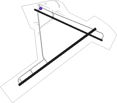
Sanford - Sanford Regl
Airport details
| Country | United States of America |
| State | Maine |
| Region | K6 |
| Airspace | Boston Ctr |
| Municipality | Sanford |
| Elevation | 244ft (74m) |
| Timezone | GMT -5 |
| Coordinates | 43.39381, -70.70800 |
| Magnetic var | |
| Type | land |
| Available since | X-Plane v10.40 |
| ICAO code | KSFM |
| IATA code | SFM |
| FAA code | SFM |
Communication
| Sanford Regl AWOS 3 | 120.025 |
| Sanford Regl CTAF/UNICOM | 123.075 |
| Sanford Regl PORTLAND Approach/Departure | 119.750 |
Approach frequencies
| ILS-cat-I | RW07 | 111.5 | 18.00mi |
| 3° GS | RW07 | 111.5 | 18.00mi |
Nearby Points of Interest:
Morrell House
-Hatch House
-Eaton House
-Louis B. Goodall Memorial Library
-Thomas Goodall House
-Emery Homestead
-Alfred Historic District
-Spiller Farm Paleoindian Site
-Sen. John Holmes House
-J.L. Prescott House
-Division No. 9 School
-Thomas Hobbs, Jr., House
-Mary R. Hurd House
-Olde Woolen Mill
-Edmund E. Goodwin House
-Smith-Emery House
-Old Grist Mill
-Alfred Shaker Historic District
-Lord-Dane House
-Lower Alewive Historic District
-Wallingford Hall
-Bourne Mansion
-District No. 5 School
-First Baptist Church
-Levi Foss House
Nearby beacons
| code | identifier | dist | bearing | frequency |
|---|---|---|---|---|
| ENE | KENNEBUNK VOR/DME | 4.5 | 71° | 117.10 |
| SF | SANFD (SANFORD) NDB | 6.5 | 245° | 349 |
| ESG | ROLLINS (ROLLINSFORD) NDB | 11.6 | 215° | 260 |
| PSM | (PORTSMOUTH) DME | 19.3 | 202° | 116.50 |
| CO | EPSOM (CONCORD) NDB | 36.5 | 250° | 216 |
| LC | BLNAP (LACONIA) NDB | 37.1 | 280° | 328 |
| LE | LEWIE (AUBURN-LEWISTON) NDB | 37.7 | 33° | 240 |
| CON | CONCORD VOR/DME | 39.3 | 259° | 112.90 |
| LWM | DME | 42.7 | 211° | 112.50 |
| MHT | MANCHESTER VOR/DME | 42.8 | 232° | 114.40 |
| MJ | FITZY (MANCHESTER) NDB | 48 | 237° | 209 |
| AUG | AUGUSTA VOR/DME | 68.2 | 45° | 114.95 |
| GMA | MAHN (WHITEFIELD) NDB | 71.9 | 315° | 386 |
Instrument approach procedures
| runway | airway (heading) | route (dist, bearing) |
|---|---|---|
| RW07 | CON (79°) | CON HAVAN (27mi, 85°) 3000ft |
| RW07 | ENE (251°) | ENE HAVAN (18mi, 247°) 3000ft HAVAN (turn) 3000ft |
| RW07 | MHT (52°) | MHT HAVAN (30mi, 45°) 3000ft |
| RNAV | HAVAN 3000ft FACNO (6mi, 66°) 2300ft XAWFE (4mi, 66°) 1020ft KSFM (3mi, 64°) 298ft (4571mi, 122°) 441ft YEYUV (4569mi, 302°) ENE (3mi, 74°) 3000ft ENE (turn) | |
| RW25 | CON (79°) | CON GUNTY (50mi, 76°) 3000ft GUNTY (turn) 2400ft |
| RW25 | MHT (52°) | MHT GUNTY (54mi, 55°) 2400ft GUNTY (turn) 2400ft |
| RW25 | SAPPE (250°) | SAPPE GUNTY (21mi, 253°) 2400ft |
| RNAV | GUNTY 2400ft ZIRMU (6mi, 246°) 1800ft KSFM (5mi, 247°) 284ft (4571mi, 122°) 1000ft GUNTY (4563mi, 302°) 2400ft GUNTY (turn) | |
| RW32 | MESHL (278°) | MESHL SACTO (13mi, 265°) 2000ft |
| RW32 | PSM (22°) | PSM SEROC (16mi, 76°) 3000ft SACTO (8mi, 15°) 2000ft |
| RNAV | SACTO 2000ft RYDER (7mi, 292°) 2000ft KSFM (6mi, 290°) 265ft (4571mi, 122°) 644ft GUNTY (4563mi, 302°) 3000ft GUNTY (turn) 3000ft |
Disclaimer
The information on this website is not for real aviation. Use this data with the X-Plane flight simulator only! Data taken with kind consent from X-Plane 12 source code and data files. Content is subject to change without notice.

