St Augustine - Northeast Florida Regl
Airport details
| Country | United States of America |
| State | Florida |
| Region | K7 |
| Airspace | Jacksonville Ctr |
| Municipality | Saint Johns County |
| Elevation | 6ft (2m) |
| Timezone | GMT -5 |
| Coordinates | 29.95252, -81.34155 |
| Magnetic var | |
| Type | land |
| Available since | X-Plane v10.40 |
| ICAO code | KSGJ |
| IATA code | UST |
| FAA code | SGJ |
Communication
| Northeast Florida Regl AWOS | 119.625 |
| Northeast Florida Regl CTAF | 127.625 |
| Northeast Florida Regl UNICOM | 122.950 |
| Northeast Florida Regl GROUND | 121.175 |
| Northeast Florida Regl TOWER | 127.625 |
| Northeast Florida Regl ApproachROACH | 120.750 |
| Northeast Florida Regl DepartureARTURE | 120.750 |
Approach frequencies
| ILS-cat-I | RW31 | 111.1 | 18.00mi |
| 3° GS | RW31 | 111.1 | 18.00mi |
Nearby Points of Interest:
Dickinson Memorial Library and Park
-Nelmar Terrace Historic District
-Horace Walker House
-North City Historic District
-Abbott Tract Historic District
-Rodriguez-Avero-Sanchez House
-Markland
-Xavier Lopez House
-St. Augustine Town Plan Historic District
-Lindsley House (St. Augustine, Florida)
-Stanbury Cottage
-Record Building
-St. Benedict the Moor School
-Llambias House
-Sanchez Powder House Site
-Grace United Methodist Church
-Sanchez Homestead
-Tenney House and Groveland Hotel
-Hastings Community Center
-Hastings High School
-St. Mary's Episcopal Church
-Green Cove Springs Historic District
-Clay County Courthouse
-Marineland of Florida
-St. Margaret's Episcopal Church and Cemetery
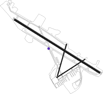
Runway info
Runway 13 / 31  | ||
| length | 2441m (8009ft) | |
| bearing | 123° / 303° | |
| width | 46m (150ft) | |
| surface | asphalt | |
| displ threshold | 323m (1060ft) / 245m (804ft) | |
| blast zone | 45m (148ft) / 61m (200ft) | |
| Runway 6 / 24 | ||
| length | 822m (2697ft) | |
| bearing | 65° / 245° | |
| width | 18m (60ft) | |
| surface | asphalt | |
| Runway 2 / 20 | ||
| length | 802m (2631ft) | |
| bearing | 23° / 203° | |
| width | 23m (75ft) | |
| surface | asphalt | |
| blast zone | 25m (82ft) / 0m (0ft) | |
Nearby beacons
| code | identifier | dist | bearing | frequency |
|---|---|---|---|---|
| SGJ | SAINT AUGUSTINE VOR/DME | 0.6 | 70° | 109.40 |
| RYD | REYNOLDS (GREEN COVE SPRINGS) NDB | 16.4 | 273° | 338 |
| NIP | JACKSONVILLE TACAN | 24.2 | 310° | 108.20 |
| CRG | CRAIG (JACKSONVILLE) VORTAC | 24.7 | 336° | 114.50 |
| NRB | MAYPORT TACAN | 26.5 | 349° | 111.40 |
| NZC | CECIL TACAN | 31.8 | 297° | 114.10 |
| JA | DINNS (JACKSONVILLE) NDB | 38.9 | 318° | 344 |
| OMN | ORMOND BEACH VORTAC | 40.7 | 161° | 112.60 |
| GN | WYNDS (GAINESVILLE) NDB | 46.4 | 251° | 269 |
| GNV | GATORS VORTAC | 50.9 | 254° | 116.20 |
| OCF | OCALA VORTAC | 65.5 | 229° | 113.70 |
Departure and arrival routes
| Transition altitude | 18000ft |
| Transition level | 18000ft |
| STAR starting points | distance | inbound heading | |
|---|---|---|---|
| ALL | |||
| HOTAR1 | 53.3 | 196° | |
Instrument approach procedures
| runway | airway (heading) | route (dist, bearing) |
|---|---|---|
| RW13 | CRG (156°) | CRG ORSOF (12mi, 165°) 2100ft TUNJU (5mi, 220°) 2000ft |
| RW13 | MATEO (31°) | MATEO EFURO (16mi, 334°) 2000ft TUNJU (5mi, 40°) 2000ft |
| RNAV | TUNJU 2000ft UDUZO (6mi, 123°) 1600ft KSGJ (6mi, 127°) 68ft YUTKA (11mi, 121°) 2000ft YUTKA (turn) | |
| RW31 | DOOKY (293°) | DOOKY YUTKA (5mi, 276°) 2000ft |
| RW31 | MACMN (310°) | MACMN YUTKA (5mi, 333°) 2000ft |
| RW31 | YUTKA (301°) | YUTKA 2000ft |
| RNAV | YUTKA 2000ft ODREC (6mi, 303°) 1700ft KSGJ (5mi, 298°) 60ft (4955mi, 110°) 218ft UDUZO (4959mi, 290°) ORSOF (8mi, 344°) 2000ft ORSOF (turn) |
Disclaimer
The information on this website is not for real aviation. Use this data with the X-Plane flight simulator only! Data taken with kind consent from X-Plane 12 source code and data files. Content is subject to change without notice.