Sarasota/bradenton - Sarasota Bradenton Intl
Airport details
| Country | United States of America |
| State | Florida |
| Region | K7 |
| Airspace | Miami Oceanic Ctr |
| Municipality | Manatee County |
| Elevation | 28ft (9m) |
| Timezone | GMT -5 |
| Coordinates | 27.39544, -82.55439 |
| Magnetic var | |
| Type | land |
| Available since | X-Plane v10.40 |
| ICAO code | KSRQ |
| IATA code | SRQ |
| FAA code | SRQ |
Communication
| Sarasota Bradenton Intl ATIS | 124.750 |
| Sarasota Bradenton Intl UNICOM | 122.950 |
| Sarasota Bradenton Intl CTAF | 120.100 |
| Sarasota Bradenton Intl Clearance DEL | 118.250 |
| Sarasota Bradenton Intl Ground Control | 121.900 |
| Sarasota Bradenton Intl Tower | 120.100 |
| Sarasota Bradenton Intl TAMPA Approach | 124.950 |
| Sarasota Bradenton Intl TAMPA Approach | 119.650 |
| Sarasota Bradenton Intl TAMPA Departure | 119.650 |
| Sarasota Bradenton Intl TAMPA Departure | 124.950 |
Approach frequencies
| ILS-cat-I | RW14 | 111.3 | 18.00mi |
| ILS-cat-I | RW32 | 109.7 | 18.00mi |
| 3° GS | RW14 | 111.3 | 18.00mi |
| 3° GS | RW32 | 109.7 | 18.00mi |
Nearby Points of Interest:
Caples'-Ringlings' Estates Historic District
-Stevens-Gilchrist House
-John M. Beasley House
-Whitfield Estates–Broughton Street Historic District
-Midway Subdivision Historic District
-Frank and Matilda Binz House
-Bryson-Crane House
-Thoms House
-Corrigan House
-Reid-Woods House
-Whitfield Estates-Lantana Avenue Historic District
-Earle House
-Overtown Historic District
-Capt. W. F. Purdy House
-J. G. Whitfield Estate
-Central-Cocoanut Historic District
-City Waterworks, Sarasota
-Sarasota Municipal Auditorium
-Leonard Reid House
-Johnson Helm House
-El Vernona Apartments-Broadway Apartments
-Appleby Building
-Egbert Reasoner House
-Dr. Joseph Halton House
-Burns Realty Company–Karl Bickel House
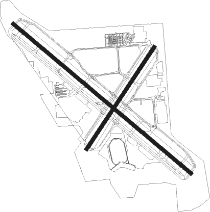
Runway info
Runway 14 / 32  | ||
| length | 2905m (9531ft) | |
| bearing | 131° / 311° | |
| width | 46m (150ft) | |
| surface | asphalt | |
| displ threshold | 411m (1348ft) / 351m (1152ft) | |
| blast zone | 61m (200ft) / 61m (200ft) | |
| Runway 4 / 22 | ||
| length | 1528m (5013ft) | |
| bearing | 41° / 221° | |
| width | 46m (150ft) | |
| surface | asphalt | |
Nearby beacons
| code | identifier | dist | bearing | frequency |
|---|---|---|---|---|
| SRQ | SARASOTA VOR/DME | 0.8 | 321° | 117 |
| MCF | MACDILL (TAMPA) TACAN | 28 | 5° | 111 |
| PIE | SAINT PETERSBURG VORTAC | 31.5 | 346° | 116.40 |
| PI | CAPOK(ST PETERSBURG-CLEARWATER NDB | 36.8 | 346° | 360 |
| TP | COSME (TAMPA) NDB | 41.4 | 2° | 368 |
| PGD | PUNTA GORDA VOR | 41.6 | 130° | 110.20 |
| LAL | LAKELAND VORTAC | 45.6 | 42° | 116 |
| FM | CALOO (FORT MYERS) NDB | 61.9 | 146° | 341 |
| RSW | LEE COUNTY (FORT MYERS) VORTAC | 66.6 | 138° | 111.80 |
Departure and arrival routes
| Transition altitude | 18000ft |
| Transition level | 18000ft |
| SID end points | distance | outbound heading | |
|---|---|---|---|
| RW14 | |||
| SRKUS4 | 91mi | 283° | |
| RW22 | |||
| SRKUS4 | 91mi | 283° | |
| RW32 | |||
| SRKUS4 | 91mi | 283° | |
| STAR starting points | distance | inbound heading | |
|---|---|---|---|
| ALL | |||
| RAYZZ2 | 45.1 | 130° | |
| RW14 | |||
| TEEGN3 | 58.6 | 143° | |
| LUBBR2 | 51.5 | 216° | |
| TRAPR3 | 45.6 | 222° | |
| RW32 | |||
| TEEGN3 | 58.6 | 143° | |
| LUBBR2 | 51.5 | 216° | |
| TRAPR3 | 45.6 | 222° | |
Instrument approach procedures
| runway | airway (heading) | route (dist, bearing) |
|---|---|---|
| RW04 | SRQ (141°) | SRQ BAYDA (12mi, 217°) 3000ft BAYDA (turn) 3000ft |
| RW04 | VIOLA (333°) | VIOLA WERPI (21mi, 306°) 3000ft BAYDA (5mi, 325°) 3000ft |
| RNAV | BAYDA 3000ft CALCA (6mi, 41°) 1700ft OSAXE (2mi, 41°) 1000ft KSRQ (3mi, 40°) 79ft (5008mi, 108°) 317ft RITLE (5006mi, 288°) PAIRS (8mi, 15°) 3000ft PAIRS (turn) 3000ft | |
| RW14 | PIE (166°) | PIE PASOE (22mi, 186°) 2000ft |
| RW14 | SRQ (141°) | SRQ PASOE (12mi, 310°) 2000ft PASOE (turn) 2000ft |
| RNAV | PASOE 2000ft FRUGL (6mi, 131°) 2000ft ETIGY (5mi, 131°) 560ft KSRQ (2mi, 130°) 77ft (5008mi, 108°) 223ft GINSE (5006mi, 288°) MURDO (10mi, 101°) 3000ft MURDO (turn) | |
| RW22 | BRDGE (262°) | BRDGE ERICO (16mi, 290°) 2000ft |
| RW22 | PIE (166°) | PIE ERICO (26mi, 143°) 2000ft |
| RNAV | ERICO 2000ft DIRAY (6mi, 221°) 1800ft RITLE (3mi, 221°) 1000ft KSRQ (3mi, 222°) 81ft (5008mi, 108°) 303ft BAYDA (5015mi, 288°) 2000ft BAYDA (turn) | |
| RW32 | SABEE (310°) | SABEE FAXID (15mi, 309°) 2000ft |
| RW32 | SRQ (141°) | SRQ FAXID (13mi, 132°) 2000ft FAXID (turn) 2000ft |
| RNAV | FAXID 2000ft RINGY (6mi, 311°) 1800ft ZALDI (4mi, 311°) 540ft KSRQ (2mi, 312°) 80ft (5008mi, 108°) 227ft ACIPU (5011mi, 288°) PAIRS (10mi, 45°) 3000ft PAIRS (turn) |
Holding patterns
| STAR name | hold at | type | turn | heading* | altitude | leg | speed limit |
|---|---|---|---|---|---|---|---|
| LUBBR2 | LUBBR | VHF | right | 4 (184)° | DME 8.0mi | ICAO rules | |
| RAYZZ2 | DAAWG | VHF | right | 272 (92)° | DME 10.0mi | ICAO rules | |
| RAYZZ2 | RAYZZ | VHF | right | 270 (90)° | DME 10.0mi | ICAO rules | |
| TEEGN3 | AVTAR | VHF | right | 347 (167)° | DME 7.0mi | ICAO rules | |
| TRAPR3 | TRAPR | VHF | right | 357 (177)° | DME 8.0mi | ICAO rules | |
| *) magnetic outbound (inbound) holding course | |||||||
Disclaimer
The information on this website is not for real aviation. Use this data with the X-Plane flight simulator only! Data taken with kind consent from X-Plane 12 source code and data files. Content is subject to change without notice.