Newburgh - New York Stewart
Airport details
| Country | United States of America |
| State | New York |
| Region | K6 |
| Airspace | Boston Ctr |
| Municipality | Town of Newburgh |
| Elevation | 491ft (150m) |
| Timezone | GMT -5 |
| Coordinates | 41.50411, -74.10484 |
| Magnetic var | |
| Type | land |
| Available since | X-Plane v10.40 |
| ICAO code | KSWF |
| IATA code | SWF |
| FAA code | SWF |
Communication
| New York Stewart Stewart ATIS | 124.575 |
| New York Stewart Stewart Unicom | 122.950 |
| New York Stewart Stewart Ground | 121.900 |
| New York Stewart Stewart Tower | 121.000 |
| New York Stewart New York Departure | 132.750 |
Approach frequencies
| ILS-cat-III | RW09 | 110.1 | 18.00mi |
| ILS-cat-I | RW27 | 109.95 | 18.00mi |
| 3° GS | RW27 | 109.95 | 18.00mi |
| 3° GS | RW09 | 110.1 | 18.00mi |
Nearby Points of Interest:
James "Squire" Patton House
-Colden Mansion Ruins
-Thomas McDowell House
-Orange Mill Historic District
-Silas Gardner House
-Brown Farmstead
-Belknap Stone House
-Haskell House
-Nathaniel Hill Brick House
-Walsh-Havemeyer House
-Benjamin Haines House
-A. Walsh Stone House and Farm Complex
-New York State Armory
-East End Historic District
-Montgomery-Grand-Liberty Streets Historic District
-Woodruff House
-Maple Lawn
-David Crawford House
-United States Post Office
-Bloomer–Dailey House and Balmville Tree
-Firthcliffe Firehouse
-John Blake House
-Oliver Brewster House
-Gilbert Millspaugh House
-Isaac Cocks House
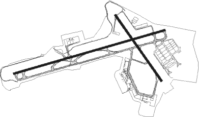
Runway info
Runway 9 / 27  | ||
| length | 3596m (11798ft) | |
| bearing | 81° / 261° | |
| width | 46m (151ft) | |
| surface | asphalt | |
| displ threshold | 610m (2001ft) / 610m (2001ft) | |
| blast zone | 61m (200ft) / 69m (226ft) | |
| Runway 16 / 34 | ||
| length | 1831m (6007ft) | |
| bearing | 142° / 322° | |
| width | 46m (151ft) | |
| surface | asphalt | |
| blast zone | 52m (171ft) / 91m (299ft) | |
Nearby beacons
| code | identifier | dist | bearing | frequency |
|---|---|---|---|---|
| SKU | STANWYCK (NEWBURGH) NDB | 3 | 68° | 261 |
| SW | NEELY (NEWBURGH) NDB | 5.6 | 262° | 335 |
| IGN | KINGSTON VOR/DME | 15.9 | 60° | 117.60 |
| HUO | HUGUENOT VOR/DME | 22.6 | 259° | 116.10 |
| CMK | CARMEL VOR/DME | 27.1 | 113° | 116.60 |
| PWL | PAWLING (POUGHKEEPSIE) VOR/DME | 27.6 | 62° | 114.30 |
| SAX | SPARTA VORTAC | 32.7 | 225° | 115.70 |
| MM | MOREE (MORRISTOWN) NDB | 38.8 | 200° | 392 |
| TEB | TETERBORO VOR/DME | 39.4 | 176° | 108.40 |
| TE | TORBY (TETERBORO) NDB | 42 | 182° | 214 |
| LGA | LA GUARDIA (NEW YORK) VOR/DME | 44.5 | 162° | 113.10 |
| STW | STILLWATER VOR/DME | 46 | 236° | 109.60 |
| CAT | CHATHAM NDB | 48.1 | 203° | 254 |
| PFH | PHILMONT (HUDSON) NDB | 48.1 | 27° | 272 |
| BDR | BRIDGEPORT VOR/DME | 48.7 | 109° | 108.80 |
| FR | FRIKK (FARMINGDALE) NDB | 51.9 | 139° | 407 |
| BWZ | BROADWAY (SCHOOLEY'S MT) VOR/DME | 53.3 | 225° | 114.20 |
| CRI | CANARSIE VOR/DME | 54.3 | 167° | 112.30 |
| JFK | KENNEDY (NEW YORK) VOR/DME | 54.4 | 159° | 115.90 |
| DNY | DE LANCEY VOR/DME | 55.6 | 308° | 112.10 |
| DPK | DEER PARK VOR/DME | 56 | 132° | 117.70 |
| SBJ | SOLBERG VOR/DME | 62.3 | 215° | 112.90 |
Departure and arrival routes
| Transition altitude | 18000ft |
| Transition level | 18000ft |
| STAR starting points | distance | inbound heading | |
|---|---|---|---|
| ALL | |||
| HUD4 | 56.0 | 312° | |
Instrument approach procedures
| runway | airway (heading) | route (dist, bearing) |
|---|---|---|
| RW09 | CAMMO (105°) | CAMMO GAGDE (9mi, 115°) 3900ft EKETE (5mi, 164°) 3000ft |
| RW09 | FALUT (63°) | FALUT EKETE (5mi, 345°) 3000ft |
| RW09 | HELON (133°) | HELON GAGDE (9mi, 220°) 3900ft EKETE (5mi, 164°) 3000ft |
| RNAV | EKETE 3000ft CEVAX (6mi, 81°) 2100ft KSWF (6mi, 82°) 542ft (4694mi, 119°) 682ft ETUGE (4683mi, 299°) 3100ft ETUGE (turn) | |
| RW16 | CAMMO (105°) | CAMMO ITOME (9mi, 76°) 4000ft FINPI (5mi, 66°) 4000ft |
| RW16 | TRESA (217°) | TRESA GEBDE (17mi, 251°) 4000ft FINPI (5mi, 246°) 4000ft |
| RNAV | FINPI 4000ft ENAXE (6mi, 142°) 3200ft SINUE (6mi, 142°) 1320ft KSWF (3mi, 150°) 511ft (4694mi, 119°) 891ft MEPTE (4685mi, 299°) 4000ft MEPTE (turn) 4000ft | |
| RW27 | FOROR (277°) | FOROR ETUGE (5mi, 345°) 3000ft |
| RW27 | PWL (242°) | PWL GOKRE (14mi, 241°) 4000ft ETUGE (5mi, 165°) 3000ft |
| RW27 | WEETS (165°) | WEETS GOKRE (21mi, 124°) 4000ft ETUGE (5mi, 165°) 3000ft |
| RNAV | ETUGE 3000ft POPOW (6mi, 261°) 2500ft KSWF (7mi, 261°) 524ft EKETE (12mi, 261°) 3000ft EKETE (turn) | |
| RW34 | CRANK (73°) | CRANK HELEP (18mi, 112°) 3900ft MEPTE (5mi, 66°) 3000ft |
| RW34 | SAX (45°) | SAX HELEP (26mi, 67°) 3000ft MEPTE (5mi, 66°) 3000ft |
| RNAV | MEPTE 3000ft FILGA (6mi, 322°) 2500ft QADED (2mi, 322°) 1700ft KSWF (5mi, 317°) 512ft (4694mi, 119°) 737ft FINPI (4704mi, 299°) 3900ft FINPI (turn) |
Holding patterns
| STAR name | hold at | type | turn | heading* | altitude | leg | speed limit |
|---|---|---|---|---|---|---|---|
| HUD4 | PWL | NDB | right | 21 (201)° | < 17999ft | 1.0min timed | ICAO rules |
| *) magnetic outbound (inbound) holding course | |||||||
Disclaimer
The information on this website is not for real aviation. Use this data with the X-Plane flight simulator only! Data taken with kind consent from X-Plane 12 source code and data files. Content is subject to change without notice.