Truth Or Consequences - Truth Or Consequences Muni
Airport details
| Country | United States of America |
| State | New Mexico |
| Region | K2 |
| Airspace | Albuquerque Ctr |
| Municipality | Truth or Consequences |
| Elevation | 4853ft (1479m) |
| Timezone | GMT -7 |
| Coordinates | 33.23536, -107.26989 |
| Magnetic var | |
| Type | land |
| Available since | X-Plane v10.40 |
| ICAO code | KTCS |
| IATA code | TCS |
| FAA code | TCS |
Communication
| Truth Or Consequences Muni ASOS | 120.675 |
| Truth Or Consequences Muni CTAF/UNICOM | 122.800 |
Nearby Points of Interest:
Hot Springs Bathhouse and Commercial Historic District in Truth or Consequences
-Elephant Butte Historic District
-Carrie Tingley Hospital Historic District
-Hillsboro High School
-George Tambling Miller and Ninette Stocker Miller House
-Will M. Robins House
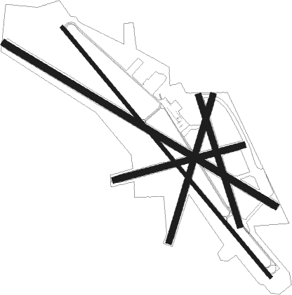
Runway info
Runway 15 / 33  | ||
| length | 912m (2992ft) | |
| bearing | 164° / 344° | |
| width | 43m (140ft) | |
| surface | hard surface | |
| Runway 13 / 31 | ||
| length | 2198m (7211ft) | |
| bearing | 140° / 320° | |
| width | 23m (75ft) | |
| surface | asphalt | |
| Runway 11 / 29 | ||
| length | 2131m (6991ft) | |
| bearing | 121° / 301° | |
| width | 46m (150ft) | |
| surface | hard surface | |
| Runway 01 / 19 | ||
| length | 1024m (3360ft) | |
| bearing | 25° / 205° | |
| width | 40m (130ft) | |
| surface | hard surface | |
| Runway 07 / 25 | ||
| length | 893m (2930ft) | |
| bearing | 81° / 261° | |
| width | 40m (130ft) | |
| surface | hard surface | |
Nearby beacons
| code | identifier | dist | bearing | frequency |
|---|---|---|---|---|
| TCS | TRUTH OR CONSEQUENCES VORTAC | 2.8 | 347° | 112.70 |
| SV | COZEY (SILVER CITY) NDB | 53.9 | 233° | 251 |
| SVC | SILVER CITY VOR/DME | 57.4 | 236° | 110.80 |
| DMN | DEMING VORTAC | 60 | 199° | 108.60 |
Instrument approach procedures
| runway | airway (heading) | route (dist, bearing) |
|---|---|---|
| RWNVA | DUCAS (334°) | DUCAS HEMAT (9mi, 293°) 10000ft LAYEN (6mi, 293°) 9000ft |
| RWNVA | KAPEY (60°) | KAPEY LAYEN (14mi, 92°) 9000ft |
| RWNVA | TCS (167°) | TCS LAYEN (17mi, 198°) 9000ft LAYEN (turn) 9000ft |
| RNAV | LAYEN 9000ft CITAL (7mi, 24°) 7500ft GALDE (4mi, 24°) 6200ft PELVE (4mi, 24°) 6000ft (6269mi, 107°) 6000ft LAYEN (6276mi, 287°) 9000ft LAYEN (turn) |
Disclaimer
The information on this website is not for real aviation. Use this data with the X-Plane flight simulator only! Data taken with kind consent from X-Plane 12 source code and data files. Content is subject to change without notice.