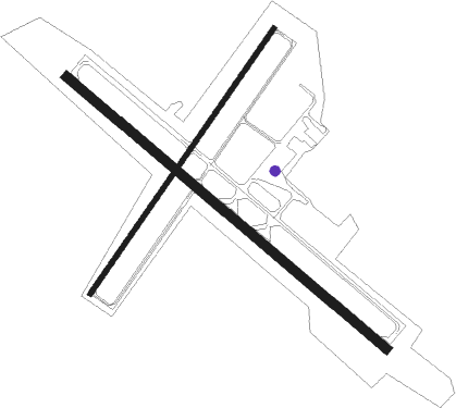
Thief River Falls - Thief River Falls Rgnl
Airport details
| Country | United States of America |
| State | Minnesota |
| Region | K3 |
| Airspace | Minneapolis Ctr |
| Municipality | Pennington County |
| Elevation | 1119ft (341m) |
| Timezone | GMT -6 |
| Coordinates | 48.06567, -96.18500 |
| Magnetic var | |
| Type | land |
| Available since | X-Plane v10.40 |
| ICAO code | KTVF |
| IATA code | TVF |
| FAA code | TVF |
Communication
| Thief River Falls RGNL AWOS | 119.025 |
| Thief River Falls RGNL CTAF | 122.800 |
| Thief River Falls RGNL CTR | 132.150 |
Approach frequencies
| ILS-cat-I | RW31 | 110.5 | 18.00mi |
| 3° GS | RW31 | 110.5 | 18.00mi |
Nearby Points of Interest:
Thief River Falls Public Library
-Thief River Falls depot
-Red Lake County Courthouse
-Clearwater Evangelical Lutheran Church
-Church of St. Peter-Catholic
-Old Mill State Park WPA/Rustic Style Historic Resources
Nearby beacons
| code | identifier | dist | bearing | frequency |
|---|---|---|---|---|
| TVF | THIEF RIVER FALLS VOR/DME | 0.2 | 338° | 114.45 |
| GF | HISER NDB | 42.1 | 258° | 345 |
| ROX | ROSEAU VOR/DME | 51.2 | 32° | 108.80 |
| HML | HUMBOLDT TACAN | 60.8 | 311° | 112.40 |
| SW | ROADD (WARROAD) NDB | 60.8 | 50° | 360 |
Instrument approach procedures
| runway | airway (heading) | route (dist, bearing) |
|---|---|---|
| RW04 | BETRA (16°) | BETRA BOOMS (24mi, 358°) 3300ft |
| RW04 | TVF (158°) | TVF BOOMS (10mi, 230°) 3300ft BOOMS (turn) 3300ft |
| RNAV | BOOMS 3300ft AGIPE (5mi, 50°) 2700ft CATSA (2mi, 51°) 1940ft KTVF (3mi, 52°) 1153ft (5653mi, 117°) 1366ft FISTS (5646mi, 297°) 3300ft FISTS (turn) | |
| RW13 | WIBIX (149°) | WIBIX WIMUS (5mi, 236°) 2700ft |
| RW13 | WIMUS (123°) | WIMUS 2700ft |
| RW13 | ZENOL (104°) | ZENOL 2700ft WIMUS (5mi, 56°) 2700ft |
| RNAV | WIMUS 2700ft ZIRMO (6mi, 123°) 2700ft CHERR (3mi, 124°) 1780ft KTVF (2mi, 123°) 1155ft (5653mi, 117°) 1365ft ZUDOL (5646mi, 297°) 2700ft ZUDOL (turn) | |
| RW22 | FALPA (194°) | FALPA FISTS (27mi, 179°) 3300ft |
| RW22 | TVF (158°) | TVF FISTS (10mi, 51°) 3300ft FISTS (turn) 3300ft |
| RNAV | FISTS 3300ft DARLL (5mi, 231°) 2700ft KEEFS (2mi, 231°) 1920ft KTVF (3mi, 229°) 1158ft (5653mi, 117°) 1369ft BOOMS (5660mi, 296°) 3300ft BOOMS (turn) | |
| RW31 | WINUL (329°) | WINUL 2700ft ZUDOL (5mi, 56°) 2700ft |
| RW31 | ZEVOS (285°) | ZEVOS 2700ft ZUDOL (5mi, 236°) 2700ft |
| RW31 | ZUDOL (304°) | ZUDOL 2700ft |
| RNAV | ZUDOL 2700ft WOBAX (6mi, 304°) 2700ft KTVF (5mi, 304°) 1168ft (5653mi, 117°) 1364ft WIMUS (5661mi, 297°) 2700ft WIMUS (turn) |
Disclaimer
The information on this website is not for real aviation. Use this data with the X-Plane flight simulator only! Data taken with kind consent from X-Plane 12 source code and data files. Content is subject to change without notice.

