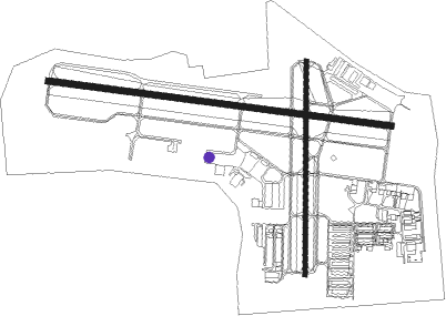
Waukesha - Waukesha Co
Airport details
| Country | United States of America |
| State | Wisconsin |
| Region | K5 |
| Airspace | Chicago Ctr |
| Municipality | Waukesha |
| Elevation | 911ft (278m) |
| Timezone | GMT -6 |
| Coordinates | 43.04103, -88.23705 |
| Magnetic var | |
| Type | land |
| Available since | X-Plane v10.40 |
| ICAO code | KUES |
| IATA code | UES |
| FAA code | UES |
Communication
| Waukesha Co AWOS 3 | 118.875 |
| Waukesha Co UNICOM | 122.950 |
| Waukesha Co Clearance DEL | 128.700 |
| Waukesha Co Ground Control | 121.600 |
| Waukesha Co Tower | 123.700 |
| Waukesha Co MILWAUKEE Approach/Departure | 128.700 |
Approach frequencies
| ILS-cat-I | RW10 | 109.5 | 18.00mi |
| 3° GS | RW10 | 109.5 | 18.00mi |
Nearby Points of Interest:
Sen. William Blair House
-St. Matthias Episcopal Church
-First Baptist Church
-Camillia Smith House
-St. Joseph's Catholic Church Complex
-Arlington Apartments
-First Methodist Church
-Chicago and North Western Depot
-First Congregational Church
-McCall Street Historic District
-Robert O. Jones House
-Everett P. Barrett House
-Harold Hornburg House
-Stephen Warren House
-Bank of Hartland
-Trapp Filling Station
-Zion Evangelical Lutheran Church
-Dansk Evangelical Lutheran Kirke
-Freewill Baptist Church
-St. John Chrysostom Church
-Delafield Fish Hatchery
-Reformed Presbyterian Church of Vernon
-Ten Chimneys
-George Lawrence Clarke Jr. House
Nearby beacons
| code | identifier | dist | bearing | frequency |
|---|---|---|---|---|
| BAE | BADGER (MILWAUKEE) VOR/DME | 5 | 328° | 116.40 |
| LJT | (MILWAUKEE) DME | 9.6 | 71° | 115.65 |
| BUU | (BURLINGTON) DME | 21.3 | 190° | 114.50 |
| RYV | ROCK RIVER (WATERTOWN) NDB | 22.8 | 285° | 371 |
| BJB | WEST BEND VOR | 23.3 | 16° | 109.80 |
| HRK | (RACINE) DME | 25 | 123° | 117.70 |
| RA | PASER (RACINE) NDB | 26.1 | 137° | 206 |
| ENW | DME | 29.7 | 145° | 109.20 |
| UNU | JUNEAU NDB | 30.9 | 310° | 344 |
| UG | WAUKE (CHICAGO/WAUKEGAN) NDB | 39.6 | 143° | 379 |
| FAH | (SHEBOYGAN) DME | 46.8 | 28° | 110 |
| JVL | JANESVILLE VOR/DME | 48 | 241° | 114.30 |
| OBK | NORTHBROOK VOR/DME | 50.8 | 161° | 113 |
| OS | POBER (OSHKOSH) NDB | 51.9 | 339° | 395 |
| OSH | OSHKOSH VORTAC | 58.6 | 341° | 116.75 |
| RFD | DME | 64.8 | 230° | 110.80 |
Departure and arrival routes
| Transition altitude | 18000ft |
| Transition level | 18000ft |
| SID end points | distance | outbound heading | |
|---|---|---|---|
| ALL | |||
| UECKR6 | 72mi | 144° | |
| ACCRA5 | 67mi | 169° | |
| STAR starting points | distance | inbound heading | |
|---|---|---|---|
| ALL | |||
| GOPAC2 | 15.5 | 39° | |
Instrument approach procedures
| runway | airway (heading) | route (dist, bearing) |
|---|---|---|
| RW10 | GREAS (72°) | GREAS WENBU (9mi, 26°) 2800ft |
| RW10 | WIDKI (127°) | WIDKI WENBU (7mi, 196°) 2800ft |
| RNAV | WENBU 2800ft WOKBO (6mi, 99°) 2300ft WENIN (2mi, 99°) 1580ft KUES (3mi, 100°) 950ft WOGPO (6mi, 98°) WOGUR (9mi, 16°) HAWKN (12mi, 302°) 3000ft HAWKN (turn) | |
| RW28 | WIGBA (247°) | WIGBA WIDNO (7mi, 179°) 3000ft |
| RNAV | WIDNO 3000ft WERBI (6mi, 269°) 3000ft VOVVU (4mi, 269°) 1640ft VEYUG (1mi, 269°) 1119ft VAGYU (5mi, 269°) HAWKN (16mi, 15°) 3000ft HAWKN (turn) |
Holding patterns
| STAR name | hold at | type | turn | heading* | altitude | leg | speed limit |
|---|---|---|---|---|---|---|---|
| GOPAC2 | LEEDN | VHF | right | 181 (1)° | DME 10.0mi | ICAO rules | |
| GOPAC2 | ZOWRO | VHF | right | 273 (93)° | DME 10.0mi | ICAO rules | |
| *) magnetic outbound (inbound) holding course | |||||||
Disclaimer
The information on this website is not for real aviation. Use this data with the X-Plane flight simulator only! Data taken with kind consent from X-Plane 12 source code and data files. Content is subject to change without notice.

