Lost Hills - Lost Hills Kern County
Airport details
| Country | United States of America |
| State | California |
| Region | K2 |
| Airspace | Los Angeles Ctr |
| Municipality | CAL Fire Kern County |
| Elevation | 272ft (83m) |
| Timezone | GMT -8 |
| Coordinates | 35.62478, -119.68614 |
| Magnetic var | |
| Type | land |
| Available since | X-Plane v10.40 |
| ICAO code | L84 |
| IATA code | n/a |
| FAA code | n/a |
Communication
| LOST HILLS KERN COUNTY CTAF | 122.900 |
Nearby Points of Interest:
Walter L. Dodge House
-Wasco Union High School
-Shafter Research Station
-The Forty Acres
-Santa Fe Passenger and Freight Depot
-The Fort (Taft, California)
-San Andreas Faults
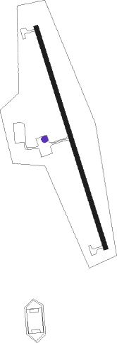
Runway info
| Runway 15 / 33 | ||
| length | 922m (3025ft) | |
| bearing | 164° / 344° | |
| width | 18m (60ft) | |
| surface | asphalt | |
Nearby beacons
| code | identifier | dist | bearing | frequency |
|---|---|---|---|---|
| AVE | AVENAL VOR/DME | 14.3 | 274° | 117.10 |
| EHF | SHAFTER (BAKERSFIELD) VORTAC | 29.9 | 103° | 115.40 |
| FLW | FELLOWS VOR/DME | 33.1 | 199° | 117.50 |
| TTE | TULE VOR/DME | 36.7 | 67° | 109.20 |
| NLC | NAVY LEMOORE TACAN | 45.2 | 339° | 113.30 |
| VIS | VISALIA VOR/DME | 45.6 | 15° | 109.40 |
| PRB | PASO ROBLES VORTAC | 46 | 273° | 114.30 |
| GLJ | GUADALUPE (SANTA MARIA) VOR | 57.5 | 231° | 111 |
| GMN | GORMAN VORTAC | 63.7 | 135° | 116.10 |
| VBG | VANDENBERG (LOMPOC) TACAN | 69.3 | 225° | 112.25 |
Disclaimer
The information on this website is not for real aviation. Use this data with the X-Plane flight simulator only! Data taken with kind consent from X-Plane 12 source code and data files. Content is subject to change without notice.