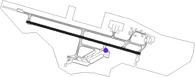
Paphos - Pafos Intl
Airport details
| Country | Cyprus |
| State | South Cyprus |
| Region | LC |
| Airspace | Nicosia Ctr |
| Municipality | Κοινότητα Αχέλειας |
| Elevation | 41ft (12m) |
| Timezone | GMT +2 |
| Coordinates | 34.71833, 32.48500 |
| Magnetic var | |
| Type | land |
| Available since | X-Plane v10.40 |
| ICAO code | LCPH |
| IATA code | PFO |
| FAA code | n/a |
Communication
| Pafos Intl Tower | 119.900 |
| Pafos Intl Approach | 120.800 |
Approach frequencies
| ILS-cat-I | RW29 | 108.9 | 18.00mi |
| 3° GS | RW29 | 108.9 | 18.00mi |
Runway info
| Runway 11 / 29 | ||
| length | 2696m (8845ft) | |
| bearing | 107° / 287° | |
| width | 45m (148ft) | |
| surface | asphalt | |
| blast zone | 7m (23ft) / 48m (157ft) | |
Nearby beacons
| code | identifier | dist | bearing | frequency |
|---|---|---|---|---|
| PHA | PAFOS NDB | 0.4 | 271° | 328 |
| PHA | PAFOS VOR/DME | 1.1 | 107° | 117.90 |
| AKR | AKROTIRI TACAN | 25 | 106° | 116 |
Departure and arrival routes
| Transition altitude | 9000ft |
| Transition level | 11000ft |
| SID end points | distance | outbound heading | |
|---|---|---|---|
| RW11 | |||
| NORD1R, NORD1C | 30mi | 83° | |
| GIPR1C | 33mi | 93° | |
| RIME1R | 44mi | 93° | |
| ESER1R | 15mi | 203° | |
| GENO1R | 29mi | 266° | |
| RW29 | |||
| NORD1W, NORD1D | 30mi | 83° | |
| GIPR1D | 33mi | 93° | |
| RIME1W | 44mi | 93° | |
| ESER1W | 15mi | 203° | |
| GENO1W | 29mi | 266° | |
| STAR starting points | distance | inbound heading | |
|---|---|---|---|
| ALL | |||
| TOBA1T | 21.7 | 120° | |
| NORD1A, NORD1T | 30.1 | 263° | |
| GIPR1A | 32.8 | 273° | |
Instrument approach procedures
| runway | airway (heading) | route (dist, bearing) |
|---|---|---|
| RW11 | ESERI (23°) | ESERI 4000ft ADUNI (16mi, 330°) 3000ft PH702 (4mi, 24°) 1700ft |
| RW11 | TOBAL (120°) | TOBAL 4000ft PH702 (12mi, 133°) 1700ft |
| RNAV | PH702 1700ft PH701 (5mi, 107°) 1700ft LCPH (6mi, 107°) 90ft PH710 (2mi, 107°) ESERI (15mi, 212°) 2000ft | |
| RW29-V | ESERI (23°) | ESERI 4000ft PH968 (9mi, 58°) 3000ft PH963 (3mi, 58°) 2000ft PH962 (4mi, 13°) 2000ft PH960 (2mi, 324°) 1300ft |
| RW29-V | TOBAL (120°) | TOBAL 4000ft PH966 (20mi, 129°) 4000ft PH965 (7mi, 129°) 3000ft PH962 (5mi, 57°) 2000ft PH960 (2mi, 324°) 1300ft |
| RNAV | PH960 1300ft LCPH (5mi, 287°) 80ft PH800 (3mi, 287°) ESERI (15mi, 190°) 2000ft | |
| RW29 | ESERI (23°) | ESERI 4000ft PH930 (15mi, 69°) 3000ft PH904 (5mi, 358°) 2100ft |
| RW29 | GIPRO (273°) | GIPRO 5000ft PH953 (16mi, 268°) 4000ft PH950 (4mi, 267°) 3000ft PH904 (4mi, 266°) 2100ft |
| RW29 | NORDI (263°) | NORDI 7000ft PH952 (7mi, 250°) 5500ft PH951 (7mi, 250°) 4000ft PH950 (4mi, 250°) 3000ft PH904 (4mi, 266°) 2100ft |
| RW29 | TOBAL (120°) | TOBAL 4000ft ENIAS (23mi, 125°) 4000ft PH910 (8mi, 125°) 3000ft PH904 (5mi, 35°) 2100ft |
| RNAV | PH904 2100ft PH901 (2mi, 287°) 2100ft LCPH (7mi, 287°) 80ft PH800 (3mi, 287°) ESERI (15mi, 190°) 2000ft |
Disclaimer
The information on this website is not for real aviation. Use this data with the X-Plane flight simulator only! Data taken with kind consent from X-Plane 12 source code and data files. Content is subject to change without notice.
