Madrid - Madrid Barajas
Airport details
| Country | Spain |
| State | Community of Madrid |
| Region | LE |
| Airspace | Madrid Ctr |
| Municipality | Madrid |
| Elevation | 1998ft (609m) |
| Timezone | GMT +1 |
| Coordinates | 40.47222, -3.56083 |
| Magnetic var | |
| Type | land |
| Available since | X-Plane v10.40 |
| ICAO code | LEMD |
| IATA code | MAD |
| FAA code | n/a |
Communication
| Madrid Barajas ATIS ARR | 118.250 |
| Madrid Barajas ATIS Departure | 130.850 |
| Madrid Barajas CLR East | 130.075 |
| Madrid Barajas CLR West | 130.350 |
| Madrid Barajas Ground Control C South | 121.975 |
| Madrid Barajas Ground Control E North | 121.750 |
| Madrid Barajas Ground Control C North | 123.150 |
| Madrid Barajas Ground Control E South | 121.625 |
| Madrid Barajas BARAJAS Tower 36L | 118.675 |
| Madrid Barajas BARAJAS Tower 36L | 118.075 |
| Madrid Barajas BARAJAS Tower 14R | 118.150 |
| Madrid Barajas BARAJAS Tower 14L | 118.975 |
| Madrid Barajas MADRID Approach | 124.025 |
| Madrid Barajas MADRID Approach | 127.500 |
| Madrid Barajas RWY 36L Departure | 118.080 |
| Madrid Barajas RWY 14R Departure | 118.155 |
| Madrid Barajas RWY 14L Departure | 118.980 |
| Madrid Barajas RWY 36R Departure | 118.680 |
Approach frequencies
| ILS-cat-III | RW18L | 111.5 | 18.00mi |
| ILS-cat-III | RW18R | 110.7 | 18.00mi |
| ILS-cat-III | RW32L | 109.9 | 18.00mi |
| ILS-cat-III | RW32R | 109.1 | 18.00mi |
| 3° GS | RW18L | 111.5 | 18.00mi |
| 3° GS | RW18R | 110.7 | 18.00mi |
| 3° GS | RW32L | 109.9 | 18.00mi |
| 3° GS | RW32R | 109.1 | 18.00mi |
Nearby Points of Interest:
gasolinera de la avenida de Aragón
-Castle of Malsobaco
-Convento, teologado e iglesia de San Pedro Mártir, Madrid
-convent of Madres Reparadoras
-Biblioteca Pública Manuel Alva
-Chapel of San Fausto
-House of Hermanitas de los Pobres
-Hospital Santa Cristina
-Gimnasio del Colegio Maravillas
-Residencia de Estudiantes
-Castellana 81
-Fundación Carlos de Amberes
-Hospital del Niño Jesús
-Residencia de Señoritas
-Instituto Valencia of Don Juan
-International Institute
-Palacete de la calle de Villanueva, Madrid
-Palace of Villamejor
-Asilo de Convalecientes, Madrid
-Artificial Mountain of Buen Retiro
-Pacífico Power Plant
-Instituto Geológico y Minero de España headquarters
-Maudes Hospital
-School of Mining Engineering of Madrid
-Palacio de Gamazo, Madrid
Runway info
Runway 14R / 32L  | ||
| length | 3995m (13107ft) | |
| bearing | 135° / 315° | |
| width | 60m (197ft) | |
| surface | asphalt | |
| displ threshold | 0m (0ft) / 930m (3051ft) | |
| blast zone | 178m (584ft) / 168m (551ft) | |
| Runway 18R / 36L | ||
| length | 4183m (13724ft) | |
| bearing | 180° / 360° | |
| width | 60m (197ft) | |
| surface | asphalt | |
| displ threshold | 808m (2651ft) / 0m (0ft) | |
| blast zone | 255m (837ft) / 0m (0ft) | |
| Runway 14L / 32R | ||
| length | 3503m (11493ft) | |
| bearing | 135° / 315° | |
| width | 60m (197ft) | |
| surface | asphalt | |
| displ threshold | 0m (0ft) / 500m (1640ft) | |
| blast zone | 255m (837ft) / 255m (837ft) | |
| Runway 18L / 36R | ||
| length | 3499m (11480ft) | |
| bearing | 180° / 360° | |
| width | 60m (197ft) | |
| surface | asphalt | |
| displ threshold | 494m (1621ft) / 0m (0ft) | |
| blast zone | 255m (837ft) / 140m (459ft) | |
Airport layout
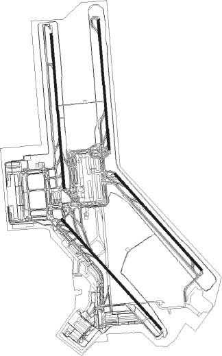
Taxiway locations
|
Parking locations
|
Nearby beacons
| code | identifier | dist | bearing | frequency |
|---|---|---|---|---|
| BRA | BARAJAS VOR/DME | 0.2 | 133° | 116.45 |
| VTZ | TORREJON (MADRID) VOR/DME | 4 | 88° | 115.10 |
| SSY | S.S.REYES VOR/DME | 4.5 | 349° | 117.85 |
| TJZ | TORREJON (MADRID) TACAN | 5.5 | 77° | 112.50 |
| CVT | CUATRO VIENTOS NDB | 11.5 | 244° | 417 |
| CNR | COLMENAR VIEJO VOR/DME | 13.1 | 315° | 117.30 |
| VGE | GETAFE (MADRID) VORTAC | 13.3 | 222° | 112.05 |
| PDT | PERALES VOR/DME | 16.3 | 136° | 116.95 |
| ECV | COLMENAR VIEJO NDB | 16.4 | 318° | 319 |
| GE | GETAFE (MADRID) NDB | 20.8 | 226° | 421 |
| RBO | ROBLEDILLO VOR/DME | 27 | 39° | 113.95 |
| NVS | NAVAS DEL REY VOR/DME | 32 | 261° | 114.95 |
| SIE | SOMOSIERRA VOR/DME | 40.8 | 356° | 115.40 |
| VTB | VILLATOBAS VOR/DME | 41.7 | 172° | 112.70 |
| TLD | TOLEDO VOR/DME | 46.6 | 237° | 113.20 |
| BAN | BARAHONA VOR/DME | 66.3 | 48° | 112.80 |
Departure and arrival routes
| Transition altitude | 13000ft |
| SID end points | distance | outbound heading | |
|---|---|---|---|
| RW14L | |||
| RBO2V, RBO2U | 27mi | 39° | |
| PINA2U, PINA2V | 53mi | 62° | |
| NAND2U, NAND2V | 70mi | 109° | |
| VTB3V | 42mi | 172° | |
| CCS4V | 144mi | 252° | |
| BARD3V | 125mi | 272° | |
| ZMR3V | 114mi | 297° | |
| SIE4V, SIE2U | 41mi | 356° | |
| RW14R | |||
| RBO2B | 27mi | 39° | |
| PINA3B | 53mi | 62° | |
| NAND2B | 70mi | 109° | |
| VTB3B, VTB2S | 42mi | 172° | |
| CCS4B, CCS2S | 144mi | 252° | |
| BARD3S, BARD3B | 125mi | 272° | |
| ZMR3B, ZMR2S | 114mi | 297° | |
| SIE4B, SIE2S | 41mi | 356° | |
| RW36L | |||
| RBO3N | 27mi | 39° | |
| PINA3N | 53mi | 62° | |
| NAND3N | 70mi | 109° | |
| VTB5L, VTB2X, VTB2N | 42mi | 172° | |
| CCS5L, CCS4N, CCS2X | 144mi | 252° | |
| BARD6L, BARD3X, BARD3N | 125mi | 272° | |
| ZMR6L, ZMR3X, ZMR2N | 114mi | 297° | |
| SIE5L, SIE2N | 41mi | 356° | |
| RW36R | |||
| RBO6W, RBO3R | 27mi | 39° | |
| PINA7W, PINA3R | 53mi | 62° | |
| NAND6W, NAND2R | 70mi | 109° | |
| VTB1R, VTB7W | 42mi | 172° | |
| CCS5W | 144mi | 252° | |
| BARD6W | 125mi | 272° | |
| ZMR3W | 114mi | 297° | |
| SIE3W | 41mi | 356° | |
| STAR starting points | distance | inbound heading | |
|---|---|---|---|
| RW18 (ALL) | |||
| SOTU6A | 94.2 | 43° | |
| TLD6A | 46.6 | 57° | |
| RIDA2A | 102.6 | 92° | |
| ZMR4A | 113.6 | 117° | |
| NONT2A | 67.6 | 149° | |
| BANE3B | 77.9 | 225° | |
| TERS6E | 66.6 | 260° | |
| ADUX6B | 68.3 | 268° | |
| PRAD7E | 73.6 | 282° | |
| VILA6E | 54.5 | 282° | |
| NASO6A | 68.9 | 334° | |
| MORA6A | 88.4 | 359° | |
| RW32 (ALL) | |||
| SOTU3C | 94.2 | 43° | |
| TLD2C | 46.6 | 57° | |
| RIDA3C | 102.6 | 92° | |
| ZMR4C | 113.6 | 117° | |
| NONT2C | 55.6 | 141° | |
| BANE2D | 66.3 | 228° | |
| TERS2Z | 66.6 | 260° | |
| ADUX1D | 68.3 | 268° | |
| PRAD2D | 73.6 | 282° | |
| VILA2D | 54.5 | 282° | |
| NASO1D | 68.9 | 334° | |
| MORA4C | 88.4 | 359° | |
Holding patterns
| STAR name | hold at | type | turn | heading* | altitude | leg | speed limit |
|---|---|---|---|---|---|---|---|
| ADUX1D | ADUXO | VHF | right | 70 (250)° | 10000ft - 24000ft | DME 5.4mi | ICAO rules |
| ADUX1D | ASBIN | VHF | left | 90 (270)° | 6000ft - 10000ft | DME 5.1mi | ICAO rules |
| ADUX1D | SIRGU | VHF | left | 90 (270)° | 8000ft - 24000ft | DME 8.6mi | ICAO rules |
| ADUX6B | ADUXO | VHF | right | 70 (250)° | 10000ft - 24000ft | DME 5.4mi | ICAO rules |
| ADUX6B | LULER | VHF | left | 81 (261)° | 8000ft - 12000ft | 1.0min timed | 210 |
| ADUX6B | NOSKO | VHF | right | 122 (302)° | 10000ft - 24000ft | DME 9.1mi | ICAO rules |
| BANE2D | ASBIN | VHF | left | 90 (270)° | 6000ft - 10000ft | DME 5.1mi | ICAO rules |
| BANE2D | BAN | NDB | right | 27 (207)° | 10000ft - 24000ft | DME 15.0mi | ICAO rules |
| BANE2D | NOSKO | VHF | right | 122 (302)° | 10000ft - 24000ft | DME 9.1mi | ICAO rules |
| BANE3B | BAN | NDB | right | 27 (207)° | 10000ft - 24000ft | DME 15.0mi | ICAO rules |
| BANE3B | LULER | VHF | left | 81 (261)° | 8000ft - 12000ft | 1.0min timed | 210 |
| BANE3B | VENUX | VHF | right | 358 (178)° | 12000ft - 24000ft | 1.0min timed | ICAO rules |
| MORA4C | BUREX | VHF | right | 227 (47)° | 12000ft - 24000ft | DME 9.0mi | ICAO rules |
| MORA4C | TOBEK | VHF | right | 227 (47)° | 5000ft - 9000ft | DME 6.1mi | ICAO rules |
| MORA6A | ETUNI | VHF | left | 249 (69)° | 12000ft - 24000ft | 1.0min timed | 220 |
| MORA6A | NVS | NDB | right | 289 (109)° | 9000ft - 24000ft | 1.0min timed | ICAO rules |
| MORA6A | RILKO | VHF | left | 308 (128)° | 11000ft - 12000ft | 1.0min timed | 210 |
| MORA6A | TLD | NDB | right | 256 (76)° | > 17000ft | 1.0min timed | ICAO rules |
| NASO1D | ASBIN | VHF | left | 90 (270)° | 6000ft - 10000ft | DME 5.1mi | ICAO rules |
| NASO1D | SIRGU | VHF | left | 90 (270)° | 8000ft - 24000ft | DME 8.6mi | ICAO rules |
| NASO6A | CJN | NDB | right | 145 (325)° | > 17000ft | 1.0min timed | ICAO rules |
| NASO6A | LULER | VHF | left | 81 (261)° | 8000ft - 12000ft | 1.0min timed | 210 |
| NASO6A | NOSKO | VHF | right | 122 (302)° | 10000ft - 24000ft | DME 9.1mi | ICAO rules |
| NONT2A | NONTU | VHF | left | 6 (186)° | 20000ft - 24000ft | 1.5min timed | ICAO rules |
| NONT2A | ORBIS | VHF | left | 6 (186)° | 12000ft - 24000ft | 1.0min timed | 220 |
| NONT2A | RILKO | VHF | left | 308 (128)° | 11000ft - 12000ft | 1.0min timed | 210 |
| NONT2C | NVS | NDB | right | 289 (109)° | 9000ft - 24000ft | 1.0min timed | ICAO rules |
| NONT2C | ORBIS | VHF | left | 6 (186)° | 12000ft - 24000ft | 1.0min timed | 220 |
| NONT2C | TOBEK | VHF | right | 227 (47)° | 5000ft - 9000ft | DME 6.1mi | ICAO rules |
| PRAD2D | ASBIN | VHF | left | 90 (270)° | 6000ft - 10000ft | DME 5.1mi | ICAO rules |
| PRAD2D | PRADO | VHF | right | 120 (300)° | 8000ft - 21000ft | DME 5.0mi | ICAO rules |
| PRAD2D | SIRGU | VHF | left | 90 (270)° | 8000ft - 24000ft | DME 8.6mi | ICAO rules |
| PRAD7E | CJN | NDB | right | 145 (325)° | > 17000ft | 1.0min timed | ICAO rules |
| PRAD7E | LULER | VHF | left | 81 (261)° | 8000ft - 12000ft | 1.0min timed | 210 |
| PRAD7E | NOSKO | VHF | right | 122 (302)° | 10000ft - 24000ft | DME 9.1mi | ICAO rules |
| PRAD7E | PRADO | VHF | right | 120 (300)° | 8000ft - 21000ft | DME 5.0mi | ICAO rules |
| RIDA2A | ETUNI | VHF | left | 249 (69)° | 12000ft - 24000ft | 1.0min timed | 220 |
| RIDA2A | RILKO | VHF | left | 308 (128)° | 11000ft - 12000ft | 1.0min timed | 210 |
| RIDA2A | USATI | VHF | left | 296 (116)° | 20000ft - 24000ft | 1.5min timed | ICAO rules |
| RIDA3C | BUREX | VHF | right | 227 (47)° | 12000ft - 24000ft | DME 9.0mi | ICAO rules |
| RIDA3C | TLD | NDB | right | 256 (76)° | > 17000ft | 1.0min timed | ICAO rules |
| RIDA3C | TOBEK | VHF | right | 227 (47)° | 5000ft - 9000ft | DME 6.1mi | ICAO rules |
| SOTU3C | BUREX | VHF | right | 227 (47)° | 12000ft - 24000ft | DME 9.0mi | ICAO rules |
| SOTU3C | TOBEK | VHF | right | 227 (47)° | 5000ft - 9000ft | DME 6.1mi | ICAO rules |
| SOTU6A | ETUNI | VHF | left | 249 (69)° | 12000ft - 24000ft | 1.0min timed | 220 |
| SOTU6A | NVS | NDB | right | 289 (109)° | 9000ft - 24000ft | 1.0min timed | ICAO rules |
| SOTU6A | RILKO | VHF | left | 308 (128)° | 11000ft - 12000ft | 1.0min timed | 210 |
| SOTU6A | TLD | NDB | right | 256 (76)° | > 17000ft | 1.0min timed | ICAO rules |
| TERS2Z | ASBIN | VHF | left | 90 (270)° | 6000ft - 10000ft | DME 5.1mi | ICAO rules |
| TERS2Z | NOSKO | VHF | right | 122 (302)° | 10000ft - 24000ft | DME 9.1mi | ICAO rules |
| TERS2Z | TERSA | VHF | right | 43 (223)° | 15000ft - 24000ft | 1.5min timed | ICAO rules |
| TERS6E | LULER | VHF | left | 81 (261)° | 8000ft - 12000ft | 1.0min timed | 210 |
| TERS6E | NOSKO | VHF | right | 122 (302)° | 10000ft - 24000ft | DME 9.1mi | ICAO rules |
| TERS6E | TERSA | VHF | right | 43 (223)° | 15000ft - 24000ft | 1.5min timed | ICAO rules |
| TLD2C | BUREX | VHF | right | 227 (47)° | 12000ft - 24000ft | DME 9.0mi | ICAO rules |
| TLD2C | TLD | NDB | right | 256 (76)° | > 17000ft | 1.0min timed | ICAO rules |
| TLD2C | TOBEK | VHF | right | 227 (47)° | 5000ft - 9000ft | DME 6.1mi | ICAO rules |
| TLD6A | ETUNI | VHF | left | 249 (69)° | 12000ft - 24000ft | 1.0min timed | 220 |
| TLD6A | NVS | NDB | right | 289 (109)° | 9000ft - 24000ft | 1.0min timed | ICAO rules |
| TLD6A | RILKO | VHF | left | 308 (128)° | 11000ft - 12000ft | 1.0min timed | 210 |
| TLD6A | TLD | NDB | right | 256 (76)° | > 17000ft | 1.0min timed | ICAO rules |
| VILA2D | ASBIN | VHF | left | 90 (270)° | 6000ft - 10000ft | DME 5.1mi | ICAO rules |
| VILA2D | SIRGU | VHF | left | 90 (270)° | 8000ft - 24000ft | DME 8.6mi | ICAO rules |
| VILA6E | CJN | NDB | right | 145 (325)° | > 17000ft | 1.0min timed | ICAO rules |
| VILA6E | LULER | VHF | left | 81 (261)° | 8000ft - 12000ft | 1.0min timed | 210 |
| VILA6E | NOSKO | VHF | right | 122 (302)° | 10000ft - 24000ft | DME 9.1mi | ICAO rules |
| ZMR4A | ORBIS | VHF | left | 6 (186)° | 12000ft - 24000ft | 1.0min timed | 220 |
| ZMR4A | PODOG | VHF | left | 285 (105)° | 20000ft - 24000ft | 1.5min timed | ICAO rules |
| ZMR4A | RILKO | VHF | left | 308 (128)° | 11000ft - 12000ft | 1.0min timed | 210 |
| ZMR4C | AVILA | VHF | left | 319 (139)° | 12000ft - 24000ft | DME 9.4mi | ICAO rules |
| ZMR4C | NVS | NDB | right | 289 (109)° | 9000ft - 24000ft | 1.0min timed | ICAO rules |
| ZMR4C | TOBEK | VHF | right | 227 (47)° | 5000ft - 9000ft | DME 6.1mi | ICAO rules |
| *) magnetic outbound (inbound) holding course | |||||||
Disclaimer
The information on this website is not for real aviation. Use this data with the X-Plane flight simulator only! Data taken with kind consent from X-Plane 12 source code and data files. Content is subject to change without notice.