Airports for X-Plane offers a convenient way to explore airports and their related communication information for the X-Plane flight simulator. It only uses data from the X-Plane flight simulator itself, and is therefore more reliable than the data that comes from real aviation websites. You can search for airports by using the ICAO code, or browse for airports per country and state. The information displayed is categorized by airport details, runway information, airport communication, approach frequencies (ILS and Glidepath details), details of nearby beacons, SIDs, STARs and approach procedures.

newark flight airliner commuter outskirts transit metro landing area passenger asphalt airborne international airport aviation jet frankfurt airport road propeller plane regional takeoff government

Ontur

Airport details

CountrySpain
StateCastile-La Mancha
RegionLE
AirspaceMadrid Ctr
MunicipalityOntur
Elevation2198ft (670m)
TimezoneGMT +1
Coordinates38.61610, -1.52706
Magnetic var
Typeland
Available sinceX-Plane v10.40
ICAO codeLEOT
IATA coden/a
FAA coden/a

Communication

Ontur Ontur Tower123.500
Nearby Points of Interest:
Arab Baths, Chinchilla de Montearagón
-
Santiago Apóstol, Liétor
-
Pozo de nieve de Alpera
-
Palace of Condes de Cirat
-
Biblioteca Pública del Estado en Albacete
-
Chalet Fontecha
-
Passage of Lodares
-
Posada del Rosario
-
Archivo Histórico Provincial de Albacete
-
Monasterio de la Encarnación (Albacete)
-
Fair of Albacete
-
Santuario de las Virtudes
-
Tortosilla rockshelters
-
Cabezo Redondo
-
Church of Saint John the Baptist
-
Cave of Niño
-
Palacio Municipal de Villena
-
Ermita de San Antón
-
Plaza Mayor
-
Conjunto histórico-artístico (Villena)

Runway info

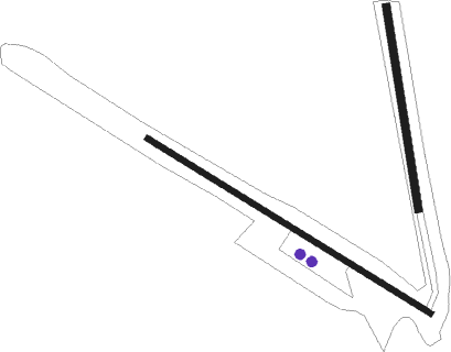
Runway 13 / 31  
 length760m (2493ft)
 bearing120° / 300°
 width12m (39ft)
 surfacedirt
Runway 02 / 20  
 length466m (1529ft)
 bearing354° / 174°
 width18m (59ft)
 surfacedirt

Airport layout - parking location Ramp


Parking locations

Nearby beacons

codeidentifierdistbearingfrequency
TABALBACETE TACAN25.2314°108
VABALBACETE VOR/DME25.2315°115.80
YESYESTE VOR/DME41.7253°115.20
TRLALCANTARILLA (MURCIA) TACAN42.3156°116.60
AIALICANTE NDB45110°330
ATEALICANTE VOR/DME48.4109°114.65
ALTALTET VOR/DME49.6110°113.80
MURMURCIA VOR/DME52.5153°114.85
VSJSAN JAVIER VORTAC60.4140°113

Disclaimer

The information on this website is not for real aviation. Use this data with the X-Plane flight simulator only! Data taken with kind consent from X-Plane 12 source code and data files. Content is subject to change without notice.