Valladolid - Villanubla
Airport details
| Country | Spain |
| State | Castile and León |
| Region | LE |
| Airspace | Madrid Ctr |
| Municipality | Villanubla |
| Elevation | 2774ft (846m) |
| Timezone | GMT +1 |
| Coordinates | 41.70611, -4.85194 |
| Magnetic var | |
| Type | land |
| Available since | X-Plane v10.40 |
| ICAO code | LEVD |
| IATA code | VLL |
| FAA code | n/a |
Communication
| Villanubla Tower | 122.200 |
Approach frequencies
| ILS-cat-III | RW23 | 109.3 | 18.00mi |
| 3° GS | RW23 | 109.3 | 18.00mi |
Nearby Points of Interest:
Monastery of Nuestra Señora del Prado
-Palacio de los Condes de Benavente, Valladolid
-Convent of Santa Isabel de Hungría, Valladolid
-Arenzana's Palace, Valladolid
-Edificio de la Electra Popular Vallisoletana
-Real Monasterio de San Joaquín y Santa Ana
-Palacio del Licenciado Butrón
-Casa Consistorial de Valladolid
-Valladolid
-Colegio de San Gregorio
-Pasaje Gutierrez
-Cárcel de la Chancillería de Valladolid
-Calle de Juan Mambrilla
-Valladolid locomotive depot
-Colegio Mayor Santa Cruz
-Archivo General de Simancas
-Church of Nuestra Señora del Pilar, Valladolid
-Church of Saint Mary of el Templo, Villalba de los Alcores
-Church of San Miguel del Pino
-Convento de San Francisco
-Tordesillas
-Church of Nuestra Señora de la Asunción, Tudela de Duero
-Church of Nuestra Señora del Tovar, Meneses de Campos
-Castle of Urueña
-Urueña
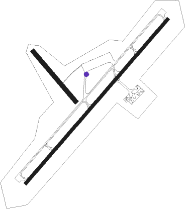
Runway info
Runway 15 / 33  | ||
| length | 903m (2963ft) | |
| bearing | 136° / 316° | |
| width | 60m (197ft) | |
| surface | dirt | |
| Runway 05 / 23 | ||
| length | 3008m (9869ft) | |
| bearing | 54° / 234° | |
| width | 45m (148ft) | |
| surface | asphalt | |
| blast zone | 211m (692ft) / 49m (161ft) | |
Nearby beacons
| code | identifier | dist | bearing | frequency |
|---|---|---|---|---|
| NUB | VILLANUBLA (VALLADOLID) VOR/DME | 0 | 127° | 113.65 |
| ZMR | ZAMORA VOR/DME | 36.9 | 257° | 117.10 |
| NEA | TABANERA VOR/DME | 38.4 | 67° | 116.75 |
| AL | MATACAN (SALAMANCA) NDB | 48.6 | 221° | 359 |
| BBI | SALAMANCA VOR/DME | 49.5 | 221° | 112.20 |
| TSC | SALAMANCA TACAN | 53.7 | 221° | 113.30 |
| EON | LEON VOR/DME | 63.9 | 318° | 112 |
Disclaimer
The information on this website is not for real aviation. Use this data with the X-Plane flight simulator only! Data taken with kind consent from X-Plane 12 source code and data files. Content is subject to change without notice.