Latina - Cuatro Vientos
Airport details
| Country | Spain |
| State | Community of Madrid |
| Region | |
| Airspace | Madrid Ctr |
| Municipality | Madrid |
| Elevation | 2266ft (691m) |
| Timezone | GMT +1 |
| Coordinates | 40.37378, -3.78306 |
| Magnetic var | |
| Type | land |
| Available since | X-Plane v10.32 |
| ICAO code | LEVS |
| IATA code | n/a |
| FAA code | n/a |
Communication
| Cuatro Vientos ATC Cuatro Vientos | 118.700 |
Nearby Points of Interest:
Forest of Saint Joseph
-Terrazas del Manzanares
-Hospital of la Venerable Orden Tercera
-La Fuentecilla
-Muslim Walls of Madrid
-Palacio del Duque del Infantado, Madrid
-Palace of the Councils
-Christian Walls of Madrid
-Church of Sacramento
-Capilla de la Cuadra de San Isidro
-Palacio de O'Reilly
-Fábrica de Tabacos
-Monastery of Corpus Christi las Carboneras
-Escuelas Pías de San Fernando
-House of Sombrerete
-Palace of Marqués de Grimaldi
-Recinto de la Villa de Madrid
-Santa Cruz Palace
-Osram factory
-Casa Gallardo
-Headquarters of the Royal Asturian Mining Company
-Casa de las Alhajas, Madrid
-Palacio del Marqués de Perales, Madrid
-Teatro Albéniz
-Casa Palazuelo, Madrid
Runway info
Runway 09L / 27R  | ||
| length | 1166m (3825ft) | |
| bearing | 93° / 273° | |
| width | 39m (127ft) | |
| surface | dirt | |
| Runway 09 / 27 | ||
| length | 1498m (4915ft) | |
| bearing | 93° / 273° | |
| width | 30m (98ft) | |
| surface | asphalt | |
| blast zone | 59m (194ft) / 47m (154ft) | |
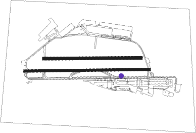
Airport layout - taxiway location A5
Taxiway locations
Parking locations
|
Nearby beacons
| code | identifier | dist | bearing | frequency |
|---|---|---|---|---|
| CVT | CUATRO VIENTOS NDB | 0.5 | 122° | 417 |
| VGE | GETAFE (MADRID) VORTAC | 5.6 | 146° | 112.05 |
| GE | GETAFE (MADRID) NDB | 10.8 | 199° | 421 |
| BRA | BARAJAS VOR/DME | 11.7 | 67° | 116.45 |
| SSY | S.S.REYES VOR/DME | 14 | 50° | 117.85 |
| VTZ | TORREJON (MADRID) VOR/DME | 15.4 | 72° | 115.10 |
| CNR | COLMENAR VIEJO VOR/DME | 16.4 | 10° | 117.30 |
| TJZ | TORREJON (MADRID) TACAN | 17.1 | 70° | 112.50 |
| ECV | COLMENAR VIEJO NDB | 19.5 | 4° | 319 |
| PDT | PERALES VOR/DME | 21.2 | 106° | 116.95 |
| NVS | NAVAS DEL REY VOR/DME | 21.3 | 269° | 114.95 |
| TLD | TOLEDO VOR/DME | 35.1 | 234° | 113.20 |
| RBO | ROBLEDILLO VOR/DME | 37.8 | 48° | 113.95 |
| VTB | VILLATOBAS VOR/DME | 38.5 | 152° | 112.70 |
| SIE | SOMOSIERRA VOR/DME | 47.4 | 13° | 115.40 |
Disclaimer
The information on this website is not for real aviation. Use this data with the X-Plane flight simulator only! Data taken with kind consent from X-Plane 12 source code and data files. Content is subject to change without notice.