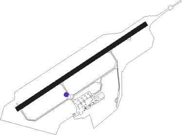
Marck - Calais Dunkerque
Airport details
| Country | France |
| State | Hauts-de-France |
| Region | LF |
| Airspace | Paris Ctr |
| Municipality | Marck |
| Elevation | 6ft (2m) |
| Timezone | GMT +1 |
| Coordinates | 50.95778, 1.95316 |
| Magnetic var | |
| Type | land |
| Available since | X-Plane v10.40 |
| ICAO code | LFAC |
| IATA code | CQF |
| FAA code | n/a |
Communication
| Calais Dunkerque CALAIS CTAF | 128.925 |
| Calais Dunkerque CALAIS Tower | 128.925 |
| Calais Dunkerque LILLE Approach | 120.275 |
| Calais Dunkerque Dep | 128.925 |
Nearby Points of Interest:
Town hall of Calais
-City walls of Gravelines
-Abbaye des Prémontrés de Licques
-Kanzel
-Boulogne–Calais railway
-Château de Colembert
-Our Lady of the Fort Church
-Grand Site des Deux Caps
-Phare du cap Gris-Nez
-Fort Mahon
-Marais Audomarois biosphere reserve
-Dunkirk city hall
-Hôpital général de Saint-Omer
-Colleges of St Omer, Bruges and Liège
-Collège des Jésuites de Saint-Omer
-Église Saint-Géry de Bierne
-Abbaye de Clairmarais
-City walls of Bergues
-Mémorial de la Légion d'honneur
-Château de Boulogne-sur-Mer
-Abbaye Sainte-Colombe de Blendecques
-tunnel d'Odre
-Vieux-Boulogne
-palais de justice de Boulogne-sur-Mer
-abbaye Saint-Wilmer de Boulogne-sur-Mer
Nearby beacons
| code | identifier | dist | bearing | frequency |
|---|---|---|---|---|
| MK | CALAIS-DUNKERQUE NDB | 4.4 | 69° | 418 |
| ING | SAINT INGLEVERT NDB | 9.1 | 251° | 387 |
| BNE | BOULOGNE SUR MER VOR | 20 | 188° | 113.80 |
| DVR | DOVER VOR/DME | 25.5 | 289° | 114.95 |
| KOK | KOKSY VORTAC | 27.6 | 79° | 114.50 |
| MRV | MERVILLE NDB | 33.3 | 111° | 404 |
| MVC | MERVILLE NDB | 33.4 | 121° | 327 |
| DD | OOSTENDE (OOSTENDE-BRUGGE) NDB | 36.1 | 75° | 352 |
| OO | OOSTENDE (OOSTENDE-BRUGGE) NDB | 38.9 | 75° | 375 |
| ABB | ABBEVILLE VOR/DME | 49.5 | 187° | 108.45 |
| CLN | CLACTON VOR/DME | 61.4 | 318° | 114.55 |
| ABY | ALBERT BRAY NDB | 67.4 | 139° | 321 |
Departure and arrival routes
| Transition altitude | 5000ft |
| SID end points | distance | outbound heading | |
|---|---|---|---|
| RW06 | |||
| KOK2J | 28mi | 79° | |
| DVR2J | 26mi | 289° | |
| RW24 | |||
| KOK2G | 28mi | 79° | |
| DVR2G | 26mi | 289° | |
| STAR starting points | distance | inbound heading | |
|---|---|---|---|
| ALL | |||
| DVR3K | 25.5 | 109° | |
| KOK3K | 27.6 | 259° | |
Instrument approach procedures
| runway | airway (heading) | route (dist, bearing) |
|---|---|---|
| RW24 | DIPKA (250°) | DIPKA 2000ft FAC24 (3mi, 251°) 2000ft |
| RW24 | NUMLO (236°) | NUMLO 2000ft DIPKA (3mi, 139°) 2000ft FAC24 (3mi, 251°) 2000ft |
| RW24 | SUDOD (263°) | SUDOD 2000ft DIPKA (4mi, 305°) 2000ft FAC24 (3mi, 251°) 2000ft |
| RW24 | TRACA (352°) | TRACA 2000ft SUDOD (14mi, 64°) 2000ft DIPKA (4mi, 305°) 2000ft FAC24 (3mi, 251°) 2000ft |
| RNAV | FAC24 2000ft LFAC (7mi, 250°) 61ft AC510 (4mi, 253°) TRACA (6mi, 128°) 2000ft TRACA (turn) 2000ft |
Holding patterns
| STAR name | hold at | type | turn | heading* | altitude | leg | speed limit |
|---|---|---|---|---|---|---|---|
| DVR3K | MK | FIX | right | 61 (241)° | 2000ft - 5000ft | 1.0min timed | 170 |
| KOK3K | MK | FIX | right | 61 (241)° | 2000ft - 5000ft | 1.0min timed | 170 |
| TRAC3K | MK | FIX | right | 61 (241)° | 2000ft - 5000ft | 1.0min timed | 170 |
| *) magnetic outbound (inbound) holding course | |||||||
Disclaimer
The information on this website is not for real aviation. Use this data with the X-Plane flight simulator only! Data taken with kind consent from X-Plane 12 source code and data files. Content is subject to change without notice.