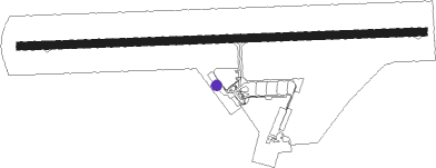
La Rochelle
Airport details
| Country | France |
| State | Nouvelle-Aquitaine |
| Region | LF |
| Airspace | Bordeaux Ctr |
| Municipality | La Rochelle |
| Elevation | 74ft (23m) |
| Timezone | GMT +1 |
| Coordinates | 46.17921, -1.19524 |
| Magnetic var | |
| Type | land |
| Available since | X-Plane v10.40 |
| ICAO code | LFBH |
| IATA code | LRH |
| FAA code | n/a |
Communication
| La Rochelle LA ROCHELLE ATIS | 126.880 |
| La Rochelle LA ROCHELLE Tower | 118.000 |
| La Rochelle LA ROCHELLE Approach | 124.200 |
| La Rochelle Dep | 118.000 |
Approach frequencies
| ILS-cat-I | RW27 | 109.55 | 18.00mi |
| 3.2° GS | RW27 | 109.55 | 18.00mi |
Nearby Points of Interest:
Villa Alsace, La Rochelle
-Porte Dauphine, La Rochelle
-hôtel d'Orbigny-Bernon
-Hôtel du Commerce
-Vauclair castle
-Hôtel de Craon
-Prefecture hotel of Charente-Maritime
-Maison au Chien
-Hôtel de la Bourse
-Palais de justice de La Rochelle
-Porte des deux moulins de la rochelle
-Maison Henri II de La Rochelle
-Immeuble, 13 rue Bazoges
-Commanderie de La Rochelle
-Maison Pillaud
-Maison, 3 rue Pas-du-Minage
-Maison, 1 rue Pas-du-Minage
-Maison Léon
-Église des Carmes
-Maison de Jean Guiton
-domaine du Portail
-Vieux-Port de La Rochelle
-bastion du Gabut
-La Rochelle rear range light
-Slipway
Nearby beacons
| code | identifier | dist | bearing | frequency |
|---|---|---|---|---|
| RL | LA ROCHELLE NDB | 4 | 92° | 322 |
| ROC | ROCHEFORT NDB | 19.5 | 144° | 396 |
| YN | LA ROCHE SUR YON LES AJONCS NDB | 30.8 | 350° | 334 |
| RY | ROYAN NDB | 36.5 | 150° | 427 |
| CGC | COGNAC CHATEAUBERNARD TACAN | 48.3 | 120° | 116.20 |
| CNA | COGNAC CHATEAUBERNARD VOR/DME | 48.3 | 120° | 114.65 |
| GL | NANTES NDB | 56.2 | 331° | 369 |
| LP | CHOLET NDB | 59.2 | 20° | 357 |
| NTS | NANTES ATLANTIQUE VOR/DME | 61.4 | 337° | 115.50 |
| POI | POITIERS BIARDS VOR | 66.4 | 75° | 113.30 |
| AGO | ANGOULEME NDB | 73.3 | 106° | 404 |
| PI | POITIERS NDB | 73.4 | 72° | 363 |
Departure and arrival routes
| Transition altitude | 5000ft |
| SID end points | distance | outbound heading | |
|---|---|---|---|
| RW09 | |||
| OLER5E | 13mi | 168° | |
| LUSO5E | 20mi | 334° | |
| RW27 | |||
| OLER5W | 13mi | 168° | |
| LUSO5W | 20mi | 334° | |
| STAR starting points | distance | inbound heading | |
|---|---|---|---|
| ALL | |||
| LUSO5L | 20.3 | 154° | |
| LUGE5L | 27.9 | 220° | |
| MARE5L | 27.3 | 343° | |
| RW09 | |||
| LUSO5C | 20.3 | 154° | |
| MARE5C | 27.3 | 343° | |
| RW27 | |||
| LUSO5M | 20.3 | 154° | |
| MARE5M | 27.3 | 343° | |
Instrument approach procedures
| runway | airway (heading) | route (dist, bearing) |
|---|---|---|
| RW09 | BH091 (55°) | BH091 5000ft BH093 (8mi, 314°) 3000ft IBH09 (3mi, 69°) FBH09 (3mi, 92°) 2000ft |
| RW09 | BH092 (121°) | BH092 5000ft BH094 (6mi, 210°) 3000ft IBH09 (3mi, 115°) FBH09 (3mi, 92°) 2000ft |
| RW09 | RL (287°) | RL 5000ft BH091 (10mi, 236°) 5000ft BH093 (8mi, 314°) 3000ft IBH09 (3mi, 69°) FBH09 (3mi, 92°) 2000ft |
| RNAV | FBH09 2000ft LFBH (6mi, 92°) 108ft RL (turn) 4000ft BH091 (10mi, 236°) 5000ft | |
| RW27 | BEMAX (272°) | BEMAX 3000ft IBH27 (6mi, 272°) 2500ft |
| RW27 | DEGAX (292°) | DEGAX 2500ft IBH27 (6mi, 4°) 2500ft |
| RW27 | RL (287°) | RL BH501 (10mi, 106°) 2500ft BH505 (3mi, 92°) 2500ft IBH27 (4mi, 4°) 2500ft |
| RW27 | XERGI (253°) | XERGI 2500ft IBH27 (6mi, 184°) 2500ft |
| RNAV | IBH27 2500ft FBH27 (5mi, 272°) 2500ft LFBH (7mi, 272°) 119ft BH512 (8mi, 272°) 2500ft BH514 (10mi, 335°) 4000ft RL (15mi, 120°) |
Holding patterns
| STAR name | hold at | type | turn | heading* | altitude | leg | speed limit |
|---|---|---|---|---|---|---|---|
| LUGE5L | RL | FIX | right | 295 (115)° | 2500ft - 9000ft | 1.0min timed | 220 |
| LUSO5L | RL | FIX | right | 295 (115)° | 2500ft - 9000ft | 1.0min timed | 220 |
| MARE5L | RL | FIX | right | 295 (115)° | 2500ft - 9000ft | 1.0min timed | 220 |
| POI5 | RL | FIX | right | 295 (115)° | 2500ft - 9000ft | 1.0min timed | 220 |
| *) magnetic outbound (inbound) holding course | |||||||
Disclaimer
The information on this website is not for real aviation. Use this data with the X-Plane flight simulator only! Data taken with kind consent from X-Plane 12 source code and data files. Content is subject to change without notice.
