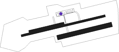
Angers/marcé - Angers Marce
Airport details
| Country | France |
| State | Pays de la Loire |
| Region | LF |
| Airspace | Brest Ctr |
| Municipality | Marcé |
| Elevation | 189ft (58m) |
| Timezone | GMT +1 |
| Coordinates | 47.56028, -0.31222 |
| Magnetic var | |
| Type | land |
| Available since | X-Plane v10.32 |
| ICAO code | LFJR |
| IATA code | ANE |
| FAA code | n/a |
Communication
| Angers Marce Angers Info | 124.700 |
| Angers Marce Nante Approach East | 124.250 |
| Angers Marce Nante Approach West | 124.425 |
Approach frequencies
| ILS-cat-I | RW26 | 108.9 | 18.00mi |
| 3° GS | RW26 | 108.9 | 18.00mi |
Nearby Points of Interest:
pierre au Loup
-Maison de maître de la Charpenterie
-Tour de Cornillé
-Briqueterie Le Croc
-Château-Bosset
-Salle seigneuriale de Briollay
-Joseph Denais Museum
-Château Beaufort-en-Vallée
-Couvent des Bénédictines de Baugé
-Presbytère de Chartrené
-Prieuré Saint-Martin de Daumeray
-Manoir de Clairefontaine (Le Vieil-Baugé)
-Château de la Rousselière
-Maison de L'Ecce Homo
-Résidence Kalouguine
-Manoir de Chauvigné
-Château du Bois
-Chapelle Saint-Jean
-Moulin de Bourgdion
-Church of the Holy Sepulchre, Angers
-Château de Clefs
-maison d'arrêt d'Angers
-Abbaye Saint-Serge
-Château des Gringuenières
-Cour d'appel d'Angers
Runway info
Nearby beacons
| code | identifier | dist | bearing | frequency |
|---|---|---|---|---|
| AS | ANGERS NDB | 6.5 | 84° | 392 |
| ANG | ANGERS VOR | 21.9 | 268° | 113 |
| LM | LE MANS NDB | 27.9 | 55° | 326 |
| LA | LAVAL NDB | 29 | 319° | 401 |
| LP | CHOLET NDB | 33.3 | 231° | 357 |
| TUR | TOURS VAL DE LOIRE TACAN | 43.1 | 98° | 113.80 |
| TUR | TOURS VAL DE LOIRE NDB | 44.3 | 90° | 331 |
| AMB | AMBOISE NDB | 55.5 | 96° | 341 |
| AMB | AMBOISE VOR/DME | 56.4 | 95° | 113.70 |
| PI | POITIERS NDB | 59.2 | 140° | 363 |
| BLB | BLOIS NDB | 61.6 | 86° | 397 |
| POI | POITIERS BIARDS VOR | 63.8 | 148° | 113.30 |
| YN | LA ROCHE SUR YON LES AJONCS NDB | 65.7 | 228° | 334 |
Instrument approach procedures
| runway | airway (heading) | route (dist, bearing) |
|---|---|---|
| RW26 | JR401 (276°) | JR401 3000ft IJR26 (4mi, 347°) 3000ft |
| RW26 | JR404 (252°) | JR404 3000ft IJR26 (4mi, 167°) 3000ft |
| RW26 | LUTIL (265°) | LUTIL 3000ft IJR26 (3mi, 268°) 3000ft |
| RNAV | IJR26 3000ft FJR26 (4mi, 264°) 3000ft LFJR (9mi, 264°) 240ft JR410 (4mi, 264°) JR412 (6mi, 50°) JR404 (13mi, 84°) 3000ft |
Disclaimer
The information on this website is not for real aviation. Use this data with the X-Plane flight simulator only! Data taken with kind consent from X-Plane 12 source code and data files. Content is subject to change without notice.

