Ajaccio/napoléon Bonaparte - Napoleon Bonaparte
Airport details
| Country | France |
| State | Corsica |
| Region | LF |
| Airspace | Marseille Ctr |
| Municipality | Ajaccio |
| Elevation | 19ft (6m) |
| Timezone | GMT +1 |
| Coordinates | 41.92389, 8.80250 |
| Magnetic var | |
| Type | land |
| Available since | X-Plane v10.40 |
| ICAO code | LFKJ |
| IATA code | AJA |
| FAA code | n/a |
Communication
| Napoleon Bonaparte AJACCIO ATIS | 126.925 |
| Napoleon Bonaparte AJACCIO ApproachROACH | 121.050 |
| Napoleon Bonaparte AJACCIO GROUND | 121.700 |
| Napoleon Bonaparte AJACCIO TOWER | 118.075 |
| Napoleon Bonaparte AJACCIO ApproachROACH | 128.800 |
| Napoleon Bonaparte AJACCIO DepartureARTURE | 118.075 |
Approach frequencies
| ILS-cat-I | RW02 | 110.3 | 18.00mi |
| 3° GS | RW02 | 110.3 | 18.00mi |
Nearby Points of Interest:
Bibliothèque Fesch
-Canal de la Gravona
-Torra d'Ancone
-Torra di Capigliolu
-U Frate è a Sora
-Église San Giovanni de Grossa
-Gulf of Porto: Calanche of Piana, Gulf of Girolata, Scandola Reserve
-église San Giovanni Battista de Corte
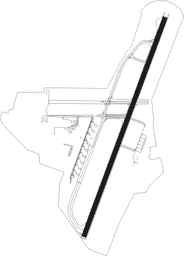
Runway info
| Runway 02 / 20 | ||
| length | 2409m (7904ft) | |
| bearing | 32° / 212° | |
| width | 45m (148ft) | |
| surface | asphalt | |
| displ threshold | 0m (0ft) / 227m (745ft) | |
| blast zone | 50m (164ft) / 70m (230ft) | |
Nearby beacons
| code | identifier | dist | bearing | frequency |
|---|---|---|---|---|
| RB | AJACCIO NDB | 0.5 | 189° | 365 |
| CT | AJACCIO NDB | 8.4 | 211° | 387 |
| IS | AJACCIO NDB | 8.6 | 262° | 341 |
| AJO | AJACCIO VOR/DME | 9.2 | 190° | 114.80 |
| SZA | SOLENZARA NDB | 26.4 | 89° | 349 |
| SZA | SOLENZARA TACAN | 26.6 | 89° | 114 |
| FA | FIGARI NDB | 27.9 | 126° | 325 |
| FGI | FIGARI VOR/DME | 28.2 | 146° | 116.70 |
| CV | CALVI SAINTE CATHERINE NDB | 39.2 | 0° | 375 |
| BP | BASTIA NDB | 44.4 | 56° | 369 |
| BTA | BASTIA PORETTA VOR/DME | 49.1 | 46° | 114.15 |
Departure and arrival routes
| Transition altitude | 5000ft |
| SID end points | distance | outbound heading | |
|---|---|---|---|
| RW20 | |||
| TORT5H, TORT6P | 88mi | 6° | |
| BTA5H, BTA6P | 49mi | 46° | |
| CORS6P, CORS5H | 35mi | 179° | |
| NEGA5H, NEGA6P | 52mi | 241° | |
| TINO6P, TINO5H | 162mi | 283° | |
| VARE5H, VARE6P | 43mi | 295° | |
| CV6P, CV5H | 201mi | 297° | |
| LONS6N, LONS5H | 62mi | 318° | |
| MERL6P | 83mi | 319° | |
| STAR starting points | distance | inbound heading | |
|---|---|---|---|
| ALL | |||
| POUL1S | 36.9 | 21° | |
| NEGA1S | 52.1 | 61° | |
| RUBA1S | 103.1 | 101° | |
| VARE1S | 43.4 | 115° | |
| LONS1S | 61.7 | 138° | |
| TORT1S | 88.2 | 186° | |
| BTA1S | 49.1 | 226° | |
| ASKA1S | 43.1 | 278° | |
| TERE1S | 36.9 | 338° | |
| RW20 | |||
| POUL2N | 36.9 | 21° | |
| NEGA2N | 52.1 | 61° | |
| RUBA2N | 103.1 | 101° | |
| VARE2N, VARE1R | 43.4 | 115° | |
| LONS2N | 61.7 | 138° | |
| TORT2N | 88.2 | 186° | |
| BTA2N | 49.1 | 226° | |
| ASKA2N | 43.1 | 278° | |
| TERE2N | 36.9 | 338° | |
Instrument approach procedures
| runway | airway (heading) | route (dist, bearing) |
|---|---|---|
| RW02-Y | HORRO (41°) | HORRO IKJ02 (5mi, 62°) 3000ft |
| RW02-Y | IS (82°) | IS KJ414 (12mi, 199°) IKJ02 (6mi, 85°) 3000ft |
| RNAV | IKJ02 3000ft FJ02Y (4mi, 32°) 3000ft MJ02Y (5mi, 32°) 1436ft KJ412 (8mi, 255°) 3000ft KJ414 (6mi, 199°) 3000ft IKJ02 (6mi, 85°) 3000ft | |
| RW02-Z | HORRO (41°) | HORRO IKJ02 (5mi, 62°) 3000ft |
| RW02-Z | IS (82°) | IS KJ414 (12mi, 199°) IKJ02 (6mi, 85°) 3000ft |
| RNAV | IKJ02 3000ft FJ02Z (4mi, 32°) 3000ft KJ400 (6mi, 32°) 900ft KJ412 (10mi, 249°) KJ414 (6mi, 199°) 3000ft IKJ02 (6mi, 85°) 3000ft | |
| RW20 | KJ600 (103°) | KJ600 IKJ20 (5mi, 76°) 3000ft |
| RW20 | KJ601 (127°) | KJ601 6000ft IKJ20 (12mi, 132°) 3000ft |
| RNAV | IKJ20 3000ft FKJ20 (3mi, 97°) 3000ft KJ602 (3mi, 97°) KJ603 (2mi, 145°) LFKJ (2mi, 212°) 66ft KJ604 (turn) HORRO (18mi, 222°) 3000ft HORRO (turn) 3000ft |
Holding patterns
| STAR name | hold at | type | turn | heading* | altitude | leg | speed limit |
|---|---|---|---|---|---|---|---|
| ASKA1S | HORRO | VHF | right | 232 (52)° | 3000ft - 10000ft | DME 5.0mi | 220 |
| ASKA2N | IS | FIX | right | 313 (133)° | 4000ft - 12000ft | 1.0min timed | 220 |
| BTA1S | HORRO | VHF | right | 232 (52)° | 3000ft - 10000ft | DME 5.0mi | 220 |
| BTA2N | IS | FIX | right | 313 (133)° | 4000ft - 12000ft | 1.0min timed | 220 |
| LONS1S | HORRO | VHF | right | 232 (52)° | 3000ft - 10000ft | DME 5.0mi | 220 |
| LONS2N | IS | FIX | right | 313 (133)° | 4000ft - 12000ft | 1.0min timed | 220 |
| NEGA1S | HORRO | VHF | right | 232 (52)° | 3000ft - 10000ft | DME 5.0mi | 220 |
| NEGA2N | IS | FIX | right | 313 (133)° | 4000ft - 12000ft | 1.0min timed | 220 |
| POUL1S | HORRO | VHF | right | 232 (52)° | 3000ft - 10000ft | DME 5.0mi | 220 |
| POUL2N | IS | FIX | right | 313 (133)° | 4000ft - 12000ft | 1.0min timed | 220 |
| RUBA1S | HORRO | VHF | right | 232 (52)° | 3000ft - 10000ft | DME 5.0mi | 220 |
| RUBA2N | IS | FIX | right | 313 (133)° | 4000ft - 12000ft | 1.0min timed | 220 |
| TERE1S | HORRO | VHF | right | 232 (52)° | 3000ft - 10000ft | DME 5.0mi | 220 |
| TERE2N | IS | FIX | right | 313 (133)° | 4000ft - 12000ft | 1.0min timed | 220 |
| TORT1S | HORRO | VHF | right | 232 (52)° | 3000ft - 10000ft | DME 5.0mi | 220 |
| TORT2N | IS | FIX | right | 313 (133)° | 4000ft - 12000ft | 1.0min timed | 220 |
| VARE1S | HORRO | VHF | right | 232 (52)° | 3000ft - 10000ft | DME 5.0mi | 220 |
| VARE2N | IS | FIX | right | 313 (133)° | 4000ft - 12000ft | 1.0min timed | 220 |
| *) magnetic outbound (inbound) holding course | |||||||
Disclaimer
The information on this website is not for real aviation. Use this data with the X-Plane flight simulator only! Data taken with kind consent from X-Plane 12 source code and data files. Content is subject to change without notice.