Clermont-ferrand - Clermont-ferrand Auvergne
Airport details
| Country | France |
| State | Auvergne-Rhône-Alpes |
| Region | LF |
| Airspace | Marseille Ctr |
| Municipality | Clermont-Ferrand |
| Elevation | 1084ft (330m) |
| Timezone | GMT +1 |
| Coordinates | 45.78001, 3.15315 |
| Magnetic var | |
| Type | land |
| Available since | X-Plane v10.40 |
| ICAO code | LFLC |
| IATA code | CFE |
| FAA code | n/a |
Communication
| Clermont-Ferrand Auvergne CLERMONT FSS | 128.625 |
| Clermont-Ferrand Auvergne LFLC ATIS | 136.400 |
| Clermont-Ferrand Auvergne CLERMONT Ground Control | 121.950 |
| Clermont-Ferrand Auvergne CLERMONT Tower | 118.625 |
| Clermont-Ferrand Auvergne CLERMONT Approach | 120.675 |
| Clermont-Ferrand Auvergne CLERMONT Approach | 122.225 |
| Clermont-Ferrand Auvergne CLERMONT Approach | 119.375 |
| Clermont-Ferrand Auvergne CLERMONT Approach | 120.500 |
Approach frequencies
| ILS-cat-III | RW26 | 111.1 | 18.00mi |
| 3° GS | RW26 | 111.1 | 18.00mi |
Nearby Points of Interest:
Menhir de Sainte-Anne
-maison d'Adam et Ève
-hôtel de la Chanterie
-Hôtel de Fontfreyde, rue Jules Guesdes
-Marché Saint-Joseph
-Lycée Jeanne-d'Arc
-Sabourin Hospital
-Hôtel Cote-Blatin
-Monuments historiques in Clermont-Ferrand
-corn market hall
-Hôtel Savaron
-Prefecture hotel of Puy-de-Dôme
-oceania clermont ferrand
-Maison Pezon
-hôtel Majestic
-Maison Domat
-town hall of Riom
-Court of Appeal of Riom
-Château de Bosredon
-Ancienne usine Bompard à Lezoux
-Porte d'enceinte de Montaigut-le-Blanc
-Chapelle funéraire de Chambon-sur-Lac
-Abbaye du Moutier (Thiers)
-Ferrier outillage
-forges Mondière
Runway info
Runway 08 / 26  | ||
| length | 3011m (9879ft) | |
| bearing | 84° / 264° | |
| width | 45m (148ft) | |
| surface | asphalt | |
| displ threshold | 0m (0ft) / 145m (476ft) | |
| Runway 01 / 19 | ||
| length | 679m (2228ft) | |
| bearing | 11° / 191° | |
| width | 60m (197ft) | |
| surface | grass | |
| Runway 08L / 26R | ||
| length | 924m (3031ft) | |
| bearing | 84° / 264° | |
| width | 45m (148ft) | |
| surface | grass | |
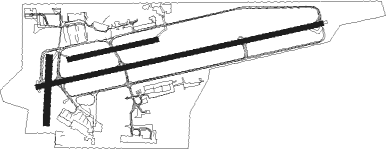
Airport layout
Taxiway locations
Parking locations
Nearby beacons
| code | identifier | dist | bearing | frequency |
|---|---|---|---|---|
| CFA | CLERMONT FERRAND AUVERGNE VOR/DME | 1.6 | 79° | 114.35 |
| ASM | CLERMONT-FERRAND/AUVERGNE NDB | 8.8 | 83° | 367 |
| TIS | THIERS VOR/DME | 17.8 | 76° | 117.50 |
| VZ | VICHY NDB | 23.1 | 35° | 403 |
| ROA | ROANNE VOR | 39.1 | 72° | 110.25 |
| RNN | ROANNE NDB | 41.9 | 69° | 358 |
| LPD | MONTLUCON-GUERET NDB | 46.2 | 303° | 398 |
| SN | SAINT YAN NDB | 50.8 | 62° | 430 |
| PY | LE PUY NDB | 53.5 | 139° | 372 |
| MOU | MOULINS VOR/DME | 59.1 | 27° | 116.70 |
| AR | AURILLAC NDB | 59.5 | 224° | 343 |
Departure and arrival routes
| Transition altitude | 6000ft |
| SID end points | distance | outbound heading | |
|---|---|---|---|
| RW08 | |||
| MOU2E | 59mi | 27° | |
| CACH2E | 87mi | 37° | |
| ROA2E | 39mi | 72° | |
| BELE2E | 41mi | 89° | |
| MEZI2E, MEZI2S | 63mi | 126° | |
| LERG2E, LERG2S | 40mi | 131° | |
| MINP2E, MINP2S | 41mi | 178° | |
| SOMT2S, SOMT2E | 22mi | 214° | |
| GERV2E | 20mi | 315° | |
| RISU2E | 42mi | 317° | |
| RIVE2E | 34mi | 353° | |
| RW26 | |||
| MOU2W | 59mi | 27° | |
| CACH2W | 87mi | 37° | |
| ROA2W | 39mi | 72° | |
| BELE2W | 41mi | 89° | |
| MEZI2D, MEZI2W | 63mi | 126° | |
| LERG2D, LERG2W | 40mi | 131° | |
| MINP2W, MINP2D | 41mi | 178° | |
| SOMT2D, SOMT2W | 22mi | 214° | |
| GERV2W | 20mi | 315° | |
| RISU2W | 42mi | 317° | |
| RIVE2W | 34mi | 353° | |
| STAR starting points | distance | inbound heading | |
|---|---|---|---|
| RW26 | |||
| EB7A | 148.7 | 40° | |
| RISU7A | 41.9 | 137° | |
| ATRI7A | 65.0 | 193° | |
| SOPA7A | 44.7 | 277° | |
| MINP7A | 30.2 | 357° | |
| MINP7V | 40.5 | 358° | |
Instrument approach procedures
| runway | airway (heading) | route (dist, bearing) |
|---|---|---|
| RW26-X | GIMAT (304°) | GIMAT 6000ft LC402 (10mi, 349°) 6000ft ILC26 (10mi, 349°) 4000ft |
| RW26-X | NIGLO (264°) | NIGLO 6100ft LC403 (8mi, 265°) 5800ft ILC26 (4mi, 265°) 4000ft |
| RW26-X | RIMOR (233°) | RIMOR 6000ft ILC26 (12mi, 169°) 4000ft |
| RNAV | ILC26 4000ft FC26X (5mi, 265°) 4000ft LFLC (10mi, 263°) 1108ft LC411 (7mi, 20°) RIMOR (14mi, 66°) 4800ft RIMOR (turn) 4800ft | |
| RW26-Y | GIMAT (304°) | GIMAT 6000ft LC402 (10mi, 349°) 6000ft ILC26 (10mi, 349°) 4000ft |
| RW26-Y | NIGLO (264°) | NIGLO 6100ft LC403 (8mi, 265°) 5800ft ILC26 (4mi, 265°) 4000ft |
| RW26-Y | RIMOR (233°) | RIMOR 6000ft ILC26 (12mi, 169°) 4000ft |
| RNAV | ILC26 4000ft FC26Y (5mi, 265°) 4000ft MC26Y (8mi, 264°) 1300ft LC411 (6mi, 357°) RIMOR (14mi, 66°) 4800ft RIMOR (turn) 4800ft | |
| RW26-Z | GIMAT (304°) | GIMAT 6000ft LC402 (10mi, 349°) 6000ft ILC26 (10mi, 349°) 4000ft |
| RW26-Z | NIGLO (264°) | NIGLO 6100ft LC403 (8mi, 265°) 5800ft ILC26 (4mi, 265°) 4000ft |
| RW26-Z | RIMOR (233°) | RIMOR 6000ft ILC26 (12mi, 169°) 4000ft |
| RNAV | ILC26 4000ft FC26Z (5mi, 265°) 4000ft LFLC (10mi, 263°) 1108ft LC409 (turn) LC411 (7mi, 13°) RIMOR (14mi, 66°) 4800ft RIMOR (turn) 4800ft |
Holding patterns
| STAR name | hold at | type | turn | heading* | altitude | leg | speed limit |
|---|---|---|---|---|---|---|---|
| ATRI7A | RIMOR | VHF | left | 40 (220)° | 6000ft - 10000ft | DME 4.4mi | 200 |
| EB7A | AMDAS | VHF | left | 146 (326)° | 9000ft - 14000ft | DME 5.0mi | 230 |
| GERV7A | GERVA | VHF | right | 320 (140)° | 5500ft - 14000ft | DME 5.0mi | 220 |
| GERV7A | RIMOR | VHF | left | 40 (220)° | 6000ft - 10000ft | DME 4.4mi | 200 |
| MINP7A | AMDAS | VHF | left | 146 (326)° | 9000ft - 14000ft | DME 5.0mi | 230 |
| PIMA7A | AMDAS | VHF | left | 146 (326)° | 9000ft - 14000ft | DME 5.0mi | 230 |
| RISU7A | RIMOR | VHF | left | 40 (220)° | 6000ft - 10000ft | DME 4.4mi | 200 |
| SOMT7A | AMDAS | VHF | left | 146 (326)° | 9000ft - 14000ft | DME 5.0mi | 230 |
| SOMT7A | SOMTI | VHF | left | 208 (28)° | 9000ft - 14000ft | DME 5.0mi | 220 |
| SOPA7A | AMDAS | VHF | left | 146 (326)° | 9000ft - 14000ft | DME 5.0mi | 230 |
| *) magnetic outbound (inbound) holding course | |||||||
Disclaimer
The information on this website is not for real aviation. Use this data with the X-Plane flight simulator only! Data taken with kind consent from X-Plane 12 source code and data files. Content is subject to change without notice.