Grenoble - Le Versoud
Airport details
| Country | France |
| State | Auvergne-Rhône-Alpes |
| Region | LF |
| Airspace | Marseille Ctr |
| Municipality | Le Versoud |
| Elevation | 722ft (220m) |
| Timezone | GMT +1 |
| Coordinates | 45.21806, 5.84861 |
| Magnetic var | |
| Type | land |
| Available since | X-Plane v10.40 |
| ICAO code | LFLG |
| IATA code | n/a |
| FAA code | n/a |
Communication
| Le Versoud LE VERSOUD ATIS | 125.225 |
| Le Versoud LE VERSOUD GROUND | 121.650 |
| Le Versoud LE VERSOUD TOWER | 121.000 |
Nearby Points of Interest:
Abbaye des Ayes (Crolles, France)
-Vauban powder magazine in Grenoble
-Town hall of Grenoble
-Isère prefecture (building)
-Hôtel de François Marc
-Palais du parlement du Dauphiné
-Château d'Herbeys
-Bibliothèque municipale de Grenoble
-Garage hélicoïdal de Grenoble
-Alpexpo
-Pavillon Keller
-Châtel de Theys
-Manoir de la Tour
-Château de Voissant
-Forges de Bonpertuis
-grange de Louisias
-château de Vaulserre
-Pont Morens
-Hôtel Nicolle de La Place
-Puits de Rioux
-Hôtel des Douanes de Chambéry
-Palais de justice de Chambéry
-Château de Quincivet
-Chapelle Saint-Anne
-Pont Royal de Chamousset
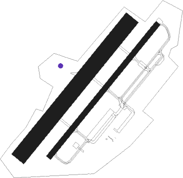
Runway info
Runway 04L / 22R  | ||
| length | 893m (2930ft) | |
| bearing | 53° / 233° | |
| width | 82m (270ft) | |
| surface | grass | |
| Runway 04 / 22 | ||
| length | 904m (2966ft) | |
| bearing | 54° / 234° | |
| width | 30m (98ft) | |
| surface | asphalt | |
| displ threshold | 0m (0ft) / 85m (279ft) | |
Nearby beacons
| code | identifier | dist | bearing | frequency |
|---|---|---|---|---|
| EG | GRENOBLE NDB | 20.9 | 288° | 397 |
| CH | CHAMBERY NDB | 22.5 | 5° | 346 |
| LTP | LA TOUR DU PIN VOR/DME | 23.7 | 303° | 115.55 |
| WS | GRENOBLE NDB | 30.6 | 282° | 291 |
| AT | ANNECY NDB | 39.3 | 15° | 384 |
| CBY | CHAMBERY VOR/DME | 40 | 352° | 115.40 |
| BR | LYON-BRON NDB | 43.2 | 295° | 388 |
| VE | VALENCE NDB | 43.9 | 248° | 320 |
| LSE | LYON SAINT EXUPERY VOR/DME | 44.9 | 305° | 114.75 |
| VNE | VIENNE REVENTIN VOR | 45.5 | 289° | 108.20 |
| PAS | PASSEIRY VOR/DME | 57.1 | 9° | 116.60 |
Disclaimer
The information on this website is not for real aviation. Use this data with the X-Plane flight simulator only! Data taken with kind consent from X-Plane 12 source code and data files. Content is subject to change without notice.