Istres/le Tubé - Istres Le Tube
Airport details
| Country | France |
| State | Provence-Alpes-Côte d'Azur |
| Region | LF |
| Airspace | Marseille Ctr |
| Municipality | Istres |
| Elevation | 81ft (25m) |
| Timezone | GMT +1 |
| Coordinates | 43.51478, 4.94702 |
| Magnetic var | |
| Type | land |
| Available since | X-Plane v10.40 |
| ICAO code | LFMI |
| IATA code | QIE |
| FAA code | n/a |
Communication
| Istres Le Tube RHONE FSS | 119.700 |
| Istres Le Tube RHONE FSS | 127.925 |
| Istres Le Tube ISTRES Ground Control | 121.850 |
| Istres Le Tube ISTRES Tower | 123.600 |
| Istres Le Tube ISTRES Tower | 122.100 |
| Istres Le Tube ISTRES Approach | 120.350 |
| Istres Le Tube ISTRES Approach | 123.300 |
Approach frequencies
| ILS-cat-I | RW15 | 111.3 | 18.00mi |
| 3° GS | RW15 | 111.3 | 18.00mi |
Nearby Points of Interest:
Fort de Bouc
-Borne milliaire de la Calanque
-Borne milliaire de Bidoussanne
-Borne milliaire
-Marseille Provence Airport
-Paradou milestone
-Via Aurelia
-Cercle linguistique d'Aix-en-Provence
-Viaduc des Eaux-salées
-Ancien hôpital Quiqueran (Les Baux-de-Provence)
-Maison Jean de Brion
-Pavillon de la reine Jeanne
-Autel de la Patrie (Fontvieille)
-Pipe organ of Notre-Dame-de-l'Assomption (Lambesc)
-Pont suspendu sur la Durance
-Hôtel de Courtois
-Council of bishops chaired by the Virgin
-Stoning of Saint Etienne
-Former archbishop's palace (Arles)
-Hôtel de Lestang-Parade
-Hôtel Damian de Vinsargues
-Hôtel de Barrême
-Arles Roman City Walls
-Borne milliaire du château d'Estoublon
-Verrerie de Trinquetaille
Runway info
| Runway 15 / 33 | ||
| length | 3752m (12310ft) | |
| bearing | 145° / 325° | |
| width | 60m (197ft) | |
| surface | asphalt | |
| blast zone | 255m (837ft) / 114m (374ft) | |
Airport layout
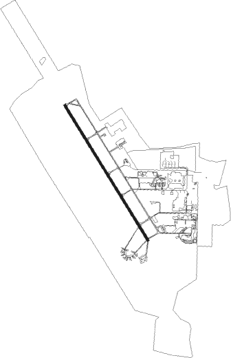
Taxiway locations
Parking locations
|
Nearby beacons
| code | identifier | dist | bearing | frequency |
|---|---|---|---|---|
| ITS | ISTRES LE TUBE VOR/DME | 0.9 | 206° | 112.70 |
| ITR | ISTRES LE TUBE NDB | 1 | 305° | 390 |
| ITR | ISTRES LE TUBE TACAN | 1.1 | 299° | 115.70 |
| MAR | MARSEILLE NDB | 8.4 | 97° | 383 |
| SAL | SALON DE PROVENCE NDB | 8.8 | 58° | 334 |
| SAL | SALON DE PROVENCE TACAN | 8.9 | 58° | 115.15 |
| MTG | MARTIGUES VOR/DME | 9.8 | 133° | 117.30 |
| MJ | MARSEILLE PROVENCE NDB | 12.6 | 106° | 406 |
| MS | MARSEILLE NDB | 16.5 | 111° | 343 |
| ALM | AIX LES MILLES NDB | 18.2 | 91° | 413 |
| MRM | MARSEILLE PROVENCE VOR/DME | 18.4 | 110° | 108.80 |
| CM | AVIGNON CAUMONT NDB | 23.7 | 354° | 369 |
| AN | CAUMONT DME-ILS | 23.9 | 354° | 110.50 |
| NG | GARONS DME-ILS | 27.5 | 295° | 109.55 |
| AVN | AVIGNON VOR/DME | 30.1 | 337° | 114.60 |
| NG | NIMES NDB | 31.2 | 302° | 354 |
| OB | MARSEILLE PROVENCE NDB | 35.7 | 112° | 395 |
| ORG | ORANGE TACAN | 37.6 | 353° | 109.40 |
| ORG | ORANGE NDB | 38.1 | 352° | 328 |
| SCL | SAINT CHRISTOL NDB | 40.2 | 46° | 348 |
| FG | MONTPELLIER NDB | 40.6 | 273° | 339 |
| FJR | MONTPELLIER MEDITERRANEE VOR/DME | 42.4 | 274° | 114.45 |
| DA | ALES CEVENNES NDB | 48.1 | 304° | 402 |
Departure and arrival routes
| Transition altitude | 5000ft |
| SID end points | distance | outbound heading | |
|---|---|---|---|
| RW15 | |||
| NASI7D | 58mi | 94° | |
| LUC7D | 58mi | 96° | |
| TINO7D | 52mi | 156° | |
| SOSU7D | 57mi | 177° | |
| MAME7D | 89mi | 216° | |
| PPG7D | 102mi | 250° | |
| AVN7D | 30mi | 337° | |
| RW33 | |||
| NASI7D | 58mi | 94° | |
| LUC7D | 58mi | 96° | |
| TINO7D | 52mi | 156° | |
| SOSU7D | 57mi | 177° | |
| MAME7D | 89mi | 216° | |
| PPG7D | 102mi | 250° | |
| AVN7D | 30mi | 337° | |
| STAR starting points | distance | inbound heading | |
|---|---|---|---|
| ALL | |||
| DIBE3D | 89.3 | 20° | |
| PPG3D | 102.0 | 70° | |
| NG3D | 257.5 | 93° | |
| JULE3D | 42.5 | 306° | |
| TINO3D | 51.6 | 336° | |
| SOSU3D | 57.3 | 357° | |
Instrument approach procedures
| runway | airway (heading) | route (dist, bearing) |
|---|---|---|
| RW15 | MI401 (111°) | MI401 4000ft MI403 (8mi, 87°) IMI15 (5mi, 109°) 2100ft FMI15 (5mi, 117°) 2100ft |
| RW15 | MI402 (103°) | MI402 3400ft IMI15 (7mi, 53°) 2100ft FMI15 (5mi, 117°) 2100ft |
| RW15 | NG (115°) | NG 4000ft MI403 (11mi, 103°) IMI15 (5mi, 109°) 2100ft FMI15 (5mi, 117°) 2100ft |
| RNAV | FMI15 2100ft LFMI (8mi, 139°) 126ft MI406 (3mi, 160°) MI407 (5mi, 249°) MI402 (14mi, 306°) 3400ft | |
| RW33 | MI421 (70°) | MI421 4000ft MI422 (5mi, 145°) MI423 (6mi, 145°) MI424 (5mi, 81°) IMI33 (3mi, 357°) 1700ft |
| RW33 | MI424 (341°) | MI424 IMI33 (3mi, 357°) 1700ft |
| RNAV | IMI33 1700ft FMI33 (4mi, 331°) 1700ft MMI33 (5mi, 331°) 143ft MI428 (5mi, 331°) 3000ft MI429 (7mi, 253°) 3000ft MI421 (5mi, 144°) 4000ft |
Holding patterns
| STAR name | hold at | type | turn | heading* | altitude | leg | speed limit |
|---|---|---|---|---|---|---|---|
| DIBE3D | ITR | FIX | right | 317 (137)° | 2600ft - 5000ft | 1.0min timed | 210 |
| JULE3D | ITR | FIX | right | 317 (137)° | 2600ft - 5000ft | 1.0min timed | 210 |
| NG3D | ITR | FIX | right | 317 (137)° | 2600ft - 5000ft | 1.0min timed | 210 |
| OB3D | ITR | FIX | right | 317 (137)° | 2600ft - 5000ft | 1.0min timed | 210 |
| PPG3D | ITR | FIX | right | 317 (137)° | 2600ft - 5000ft | 1.0min timed | 210 |
| SOSU3D | ITR | FIX | right | 317 (137)° | 2600ft - 5000ft | 1.0min timed | 210 |
| TINO3D | ITR | FIX | right | 317 (137)° | 2600ft - 5000ft | 1.0min timed | 210 |
| *) magnetic outbound (inbound) holding course | |||||||
Disclaimer
The information on this website is not for real aviation. Use this data with the X-Plane flight simulator only! Data taken with kind consent from X-Plane 12 source code and data files. Content is subject to change without notice.