Montpellier/méditerranée - Montpellier/mediterranee
Airport details
| Country | France |
| State | Occitania |
| Region | LF |
| Airspace | Marseille Ctr |
| Municipality | Mauguio |
| Elevation | 16ft (5m) |
| Timezone | GMT +1 |
| Coordinates | 43.57623, 3.96831 |
| Magnetic var | |
| Type | land |
| Available since | X-Plane v10.40 |
| ICAO code | LFMT |
| IATA code | MPL |
| FAA code | n/a |
Communication
| Montpellier/Mediterranee LFMT ATIS | 124.125 |
| Montpellier/Mediterranee MONTPELLIER Ground Control | 121.950 |
| Montpellier/Mediterranee MONTPELLIER Tower | 118.775 |
| Montpellier/Mediterranee MONTPELLIER Tower | 118.200 |
| Montpellier/Mediterranee MONTPELLIER Approach | 120.375 |
| Montpellier/Mediterranee MONTPELLIER Approach | 130.850 |
| Montpellier/Mediterranee MONTPELLIER Approach | 133.775 |
Approach frequencies
| ILS-cat-I | RW30R | 108.55 | 18.00mi |
| 3° GS | RW30R | 108.55 | 18.00mi |
Nearby Points of Interest:
Domaine de Grammont
-Montpellier war memorial
-logis de la Croix d'or
-Saint-Côme hotel
-Bachy-du-Cayla hotel
-Varennes hotel
-Griffy hotel
-Pipe organ of Basilique Notre-Dame des Tables de Montpellier
-Hortoles hotel
-boutique hotel baudon de mauny
-treasurer's Hotel of the stock exchange
-hotel of Montcalm
-Uston hotel
-glacière de Castelnau-le-Lez
-Ancienne synagogue de Montpellier
-Ricard hotel
-Belleval hotel
-Cambacérès-Murles hotel
-Lunas hotel
-Duffau hotel
-Palais de Justice de Montpellier
-promenade of Peyrou
-Scots College, Montpellier
-Oppidum de la Roque
-Espiguette
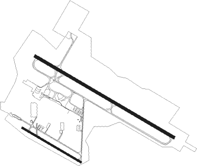
Runway info
Runway 12L / 30R  | ||
| length | 2602m (8537ft) | |
| bearing | 117° / 297° | |
| width | 50m (164ft) | |
| surface | asphalt | |
| Runway 12R / 30L | ||
| length | 1100m (3609ft) | |
| bearing | 117° / 297° | |
| width | 30m (98ft) | |
| surface | asphalt | |
| displ threshold | 100m (328ft) / 0m (0ft) | |
Nearby beacons
| code | identifier | dist | bearing | frequency |
|---|---|---|---|---|
| FJR | MONTPELLIER MEDITERRANEE VOR/DME | 0.3 | 72° | 114.45 |
| FG | MONTPELLIER NDB | 2.3 | 113° | 339 |
| NG | GARONS DME-ILS | 22.5 | 67° | 109.55 |
| NG | NIMES NDB | 25.4 | 57° | 354 |
| DA | ALES CEVENNES NDB | 30.3 | 20° | 402 |
| ZR | VIAS DME-ILS | 31.1 | 248° | 109.35 |
| ZR | BEZIERS VIAS NDB | 33.4 | 250° | 397 |
| ITR | ISTRES LE TUBE TACAN | 41.8 | 93° | 115.70 |
| ITR | ISTRES LE TUBE NDB | 41.9 | 93° | 390 |
| AVN | AVIGNON VOR/DME | 42 | 62° | 114.60 |
| ITS | ISTRES LE TUBE VOR/DME | 42.5 | 94° | 112.70 |
| AN | CAUMONT DME-ILS | 45.2 | 70° | 110.50 |
| CM | AVIGNON CAUMONT NDB | 45.2 | 70° | 369 |
| ORG | ORANGE NDB | 51.4 | 57° | 328 |
| ORG | ORANGE TACAN | 51.5 | 58° | 109.40 |
| MTL | MONTELIMAR ANCONE VOR/DME | 68.4 | 40° | 113.65 |
Departure and arrival routes
| Transition altitude | 5000ft |
| SID end points | distance | outbound heading | |
|---|---|---|---|
| RW12L | |||
| ETRE6E, ETRE6L | 101mi | 23° | |
| MTL6L, MTL6E | 68mi | 40° | |
| MARI6S, MARI6L | 25mi | 111° | |
| PPG6S, PPG6L | 69mi | 233° | |
| KELA6S, KELA6L | 54mi | 250° | |
| MASA6L, MASA6S | 75mi | 266° | |
| NG6S, NG6L | 215mi | 273° | |
| BRUS6L, BRUS6S | 42mi | 280° | |
| MEN6S, MEN6L | 71mi | 322° | |
| RW30R | |||
| ETRE6R, ETRE6D | 101mi | 23° | |
| MTL6R, MTL6D | 68mi | 40° | |
| MARI6N, MARI6R | 25mi | 111° | |
| PPG6N | 69mi | 233° | |
| KELA6N, KELA6R | 54mi | 250° | |
| MASA6N | 75mi | 266° | |
| NG6R, NG6N | 215mi | 273° | |
| BRUS6N, BRUS6R | 42mi | 280° | |
| MEN6N, MEN6R | 71mi | 322° | |
| STAR starting points | distance | inbound heading | |
|---|---|---|---|
| RW12L | |||
| KELA6T | 31.1 | 68° | |
| BRUS6T | 24.6 | 100° | |
| MEN6T | 50.7 | 134° | |
| MEN6E | 71.0 | 142° | |
| MARI6T | 14.1 | 290° | |
| RW30R | |||
| KELA6T | 31.1 | 68° | |
| BRUS6T | 24.6 | 100° | |
| MEN6T | 50.7 | 134° | |
| MEN6E | 71.0 | 142° | |
| MARI6T | 14.1 | 290° | |
Instrument approach procedures
| runway | airway (heading) | route (dist, bearing) |
|---|---|---|
| RW12L | GIGNA (101°) | GIGNA MT505 (7mi, 56°) 5000ft IT12L (6mi, 113°) 3000ft |
| RW12L | LEKLA (115°) | LEKLA MT503 (7mi, 113°) MT505 (7mi, 113°) 5000ft IT12L (6mi, 113°) 3000ft |
| RW12L | MT500 (102°) | MT500 3000ft IT12L (4mi, 44°) 3000ft |
| RW12L | MT502 (158°) | MT502 4000ft MT504 (4mi, 257°) 3000ft IT12L (3mi, 224°) 3000ft |
| RNAV | IT12L 3000ft FT12L (4mi, 117°) 2500ft LFMT (7mi, 118°) 66ft ESPIG (7mi, 116°) MT510 (4mi, 146°) 2000ft ESPIG (4mi, 326°) ESPIG (turn) 2000ft |
Holding patterns
| STAR name | hold at | type | turn | heading* | altitude | leg | speed limit |
|---|---|---|---|---|---|---|---|
| BRUS6T | ESPIG | VHF | left | 124 (304)° | 2000ft - 8000ft | DME 5.0mi | 220 |
| BRUS6T | GIGNA | VHF | left | 282 (102)° | 5000ft - 11000ft | DME 5.0mi | 220 |
| KELA6T | BALRU | VHF | left | 243 (63)° | 3000ft - 7000ft | DME 3.0mi | 170 |
| KELA6T | ESPIG | VHF | left | 124 (304)° | 2000ft - 8000ft | DME 5.0mi | 220 |
| MARI6T | ESPIG | VHF | left | 124 (304)° | 2000ft - 8000ft | DME 5.0mi | 220 |
| MEN6E | ESPIG | VHF | left | 124 (304)° | 2000ft - 8000ft | DME 5.0mi | 220 |
| MEN6T | ESPIG | VHF | left | 124 (304)° | 2000ft - 8000ft | DME 5.0mi | 220 |
| MEN6T | GIGNA | VHF | left | 282 (102)° | 5000ft - 11000ft | DME 5.0mi | 220 |
| NG6T | ESPIG | VHF | left | 124 (304)° | 2000ft - 8000ft | DME 5.0mi | 220 |
| PPG6T | ESPIG | VHF | left | 124 (304)° | 2000ft - 8000ft | DME 5.0mi | 220 |
| *) magnetic outbound (inbound) holding course | |||||||
Disclaimer
The information on this website is not for real aviation. Use this data with the X-Plane flight simulator only! Data taken with kind consent from X-Plane 12 source code and data files. Content is subject to change without notice.