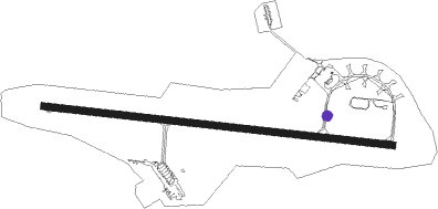
Maupertus - Cherbourg Maupertus
Airport details
| Country | France |
| State | Normandy |
| Region | LF |
| Airspace | Brest Ctr |
| Municipality | Maupertus-sur-Mer |
| Elevation | 458ft (140m) |
| Timezone | GMT +1 |
| Coordinates | 49.65078, -1.47530 |
| Magnetic var | |
| Type | land |
| Available since | X-Plane v10.40 |
| ICAO code | LFRC |
| IATA code | CER |
| FAA code | n/a |
Communication
| Cherbourg Maupertus CTAF | 119.625 |
| Cherbourg Maupertus Twr | 119.625 |
| Cherbourg Maupertus Dep | 119.625 |
Approach frequencies
| ILS-cat-I | RW28 | 110.55 | 18.00mi |
| 3° GS | RW28 | 110.55 | 18.00mi |
Nearby Points of Interest:
Stèle à Marie Ravenel
-Statue de Jean-François Millet, Cherbourg
-Hôtel Épron de la Horie
-Hôtel de ville de Cherbourg
-Town hall of La Pernelle
-Hôtel d'Eu, Valognes
-Pavillon de Grenneville
-Hôtel Dorléans, Valognes
-Hôtel Anneville du Vast, Valognes
-Hôtel de Thieuville, Valognes
-Hôtel de Grandval-Caligny, Valognes
-Maison du Grand quartier
-hôpital de Valognes
-redoute de Réville
-Grande cheminée de Quinéville
-Presbytère de Colomby
-Abbaye Notre-Dame de Grâce (Bricquebec, France)
-Hague-Dick
-Chapelle du prieuré Saint-Hermel
-Presbytère d'Étienville
-Camp du Castel
-Château de l'Isle-Marie
-La Bastille (Beuzeville-la-Bastille)
-Abbaye de Blanchelande
-baptistère de Portbail
Nearby beacons
| code | identifier | dist | bearing | frequency |
|---|---|---|---|---|
| MP | CHERBOURG NDB | 4 | 97° | 373 |
| ALD | ALDERNEY NDB | 28.3 | 275° | 383 |
| JSY | JERSEY VOR/DME | 34.1 | 233° | 112.20 |
| JW | JERSEY NDB | 39.4 | 239° | 329 |
Instrument approach procedures
| runway | airway (heading) | route (dist, bearing) |
|---|---|---|
| RW28 | ETUSA (294°) | ETUSA UVRAN (6mi, 17°) 3000ft |
| RW28 | NOSDU (262°) | NOSDU UVRAN (6mi, 197°) 3000ft |
| RNAV | UVRAN 3000ft FRC28 (5mi, 277°) 3000ft LFRC (9mi, 277°) 477ft RC410 (1mi, 277°) RC412 (8mi, 63°) NOSDU (10mi, 97°) 3000ft NOSDU (turn) 3000ft |
Disclaimer
The information on this website is not for real aviation. Use this data with the X-Plane flight simulator only! Data taken with kind consent from X-Plane 12 source code and data files. Content is subject to change without notice.
