Cuers/pierrefeu - Cuers Pierrefeu
Airport details
| Country | France |
| State | Provence-Alpes-Côte d'Azur |
| Region | LF |
| Airspace | Marseille Ctr |
| Municipality | Pierrefeu-du-Var |
| Elevation | 269ft (82m) |
| Timezone | GMT +1 |
| Coordinates | 43.24705, 6.12053 |
| Magnetic var | |
| Type | land |
| Available since | X-Plane v10.40 |
| ICAO code | LFTF |
| IATA code | n/a |
| FAA code | n/a |
Communication
| Cuers Pierrefeu CUERS Tower | 122.700 |
Nearby Points of Interest:
Porte Saint-Paul, Hyères
-Dellor mansion
-Porte de Fenouillet, Hyères
-hotel du parc
-Villa mauresque
-Villa tunisienne
-Le Plantier de Costebelle
-Menhirs de la Ferme Lambert
-Comédie de Toulon
-Hôpital Chalucet et jardin Alexandre Ier
-Monument aux morts de la Première Guerre mondiale, Toulon
-Ancien hôtel de ville de Toulon
-Corderie de Toulon
-Porte de l'Arsenal - Musée de la Marine
-Pont basculant de la Seyne-sur-Mer
-Heritage House
-Oratoire des Béguines
-Couvent des Dominicains de Saint-Maximin-la-Sainte-Baume
-Port Grimaud
-Château Bertaud
-Domaine des Treilles
-Bastide Marin
-Ancienne synagogue de Trets
-Tour Suffren
-Chapelle Sainte-Anne de Saint-Tropez
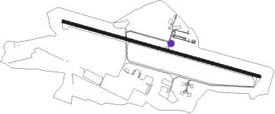
Runway info
| Runway 11 / 29 | ||
| length | 1972m (6470ft) | |
| bearing | 105° / 285° | |
| width | 30m (98ft) | |
| surface | asphalt | |
| displ threshold | 310m (1017ft) / 295m (968ft) | |
Nearby beacons
| code | identifier | dist | bearing | frequency |
|---|---|---|---|---|
| NFA | CUERS NDB | 0.2 | 86° | 640 |
| HYE | HYERES LE PALYVESTRE TACAN | 8.8 | 170° | 109 |
| LUC | LE LUC LE CANNET VOR/DME | 10 | 45° | 113 |
| MFB | BRIGNOLES NDB | 11 | 328° | 688 |
| TLN | HYERES NDB | 12.9 | 171° | 322 |
| LC | CANNET DME-ILS | 14.1 | 62° | 109.30 |
| LU | LE LUC NDB | 19.5 | 71° | 378 |
| OB | MARSEILLE PROVENCE NDB | 19.9 | 268° | 395 |
| STP | SAINT TROPEZ VOR/DME | 21.1 | 93° | 116.50 |
| MUS | NICE COTE D'AZUR NDB | 22.7 | 74° | 428 |
| MRM | MARSEILLE PROVENCE VOR/DME | 35.5 | 279° | 108.80 |
| ALM | AIX LES MILLES NDB | 36.4 | 289° | 413 |
| MS | MARSEILLE NDB | 37.5 | 280° | 343 |
| CNM | CANNES VOR | 37.7 | 67° | 111.40 |
| MJ | MARSEILLE PROVENCE NDB | 41.1 | 282° | 406 |
| CSC | MANDELIEU (CANNES) NDB | 43.6 | 73° | 385 |
| DGN | DIGNE VOR | 44.7 | 358° | 113.85 |
| MAR | MARSEILLE NDB | 45.3 | 284° | 383 |
| SCL | SAINT CHRISTOL NDB | 55.2 | 322° | 348 |
Disclaimer
The information on this website is not for real aviation. Use this data with the X-Plane flight simulator only! Data taken with kind consent from X-Plane 12 source code and data files. Content is subject to change without notice.