Budapest - Budapest Ferenc Liszt Intl
Airport details
| Country | Hungary |
| State | Pest |
| Region | LH |
| Airspace | Budapest Ctr |
| Municipality | Budapest |
| Elevation | 495ft (151m) |
| Timezone | GMT +1 |
| Coordinates | 47.43556, 19.23272 |
| Magnetic var | |
| Type | land |
| Available since | X-Plane v10.40 |
| ICAO code | LHBP |
| IATA code | BUD |
| FAA code | n/a |
Communication
| Budapest Ferenc Liszt Intl LHBP ATIS | 132.380 |
| Budapest Ferenc Liszt Intl BUDAPEST CLD | 134.540 |
| Budapest Ferenc Liszt Intl BUDAPEST APRON 2 | 122.440 |
| Budapest Ferenc Liszt Intl BUDAPEST Ground Control | 121.910 |
| Budapest Ferenc Liszt Intl BUDAPEST APRON 1 | 131.555 |
| Budapest Ferenc Liszt Intl BUDAPEST Tower | 118.100 |
| Budapest Ferenc Liszt Intl BUDAPEST DIR | 119.510 |
| Budapest Ferenc Liszt Intl BUDAPEST Approach | 123.860 |
| Budapest Ferenc Liszt Intl BUDAPEST Approach | 122.975 |
Approach frequencies
| ILS-cat-III | RW31R | 109.5 | 18.00mi |
| ILS-cat-III | RW13R | 110.5 | 18.00mi |
| ILS-cat-II | RW13L | 109.15 | 18.00mi |
| ILS-cat-II | RW31L | 111.5 | 18.00mi |
| 3° GS | RW13L | 109.15 | 18.00mi |
| 3° GS | RW31R | 109.5 | 18.00mi |
| 3° GS | RW13R | 110.5 | 18.00mi |
| 3° GS | RW31L | 111.5 | 18.00mi |
Nearby Points of Interest:
Semmelweis University Józsefvárosi Clinical Complex
-Hungária Mill
-Hungarian Institute of Geology and Geophysics
-Jewish Chevra Kadisa Home of Elderly
-Saint Catherine of Alexandria Church, Tabán
-Bécsi út, 56
-Kútvölgyi Úti Oktatókórház
-Béla király 20, Frivaldszky Villa
-Ócsa Protected Landscape Area
-Szentendre Town Hall
-Upper Kiskunság alkaline steppes
Runway info
Runway 13R / 31L  | ||
| length | 3013m (9885ft) | |
| bearing | 122° / 302° | |
| width | 45m (148ft) | |
| surface | concrete | |
| blast zone | 60m (197ft) / 60m (197ft) | |
| Runway 13L / 31R | ||
| length | 3711m (12175ft) | |
| bearing | 122° / 302° | |
| width | 45m (148ft) | |
| surface | concrete | |
| blast zone | 60m (197ft) / 60m (197ft) | |
Airport layout
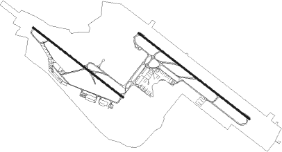
Taxiway locations
|
Parking locations
|
Nearby beacons
| code | identifier | dist | bearing | frequency |
|---|---|---|---|---|
| BUD | BUDAPEST VOR/DME | 1.1 | 48° | 117.30 |
| MNR | MONOR VOR/DME | 9.2 | 120° | 112.50 |
| TPS | TAPIOSAP VOR/DME | 9.3 | 75° | 115.90 |
| PTB | PUSZTASZABOLCS VOR/DME | 26.2 | 240° | 117.10 |
| NT | KECSKEMET NDB | 34.8 | 137° | 313 |
| N | KECSKEMET NDB | 36.4 | 136° | 440 |
| KET | KECSKEMET VORTAC | 36.6 | 136° | 114.15 |
| T | KECSKEMET NDB | 38.7 | 134° | 440 |
| TN | KECSKEMET NDB | 40.1 | 133° | 313 |
| A | SZOLNOK NDB | 45 | 108° | 422 |
| AO | SZOLNOK NDB | 45.2 | 110° | 282 |
| BUG | BUGAC VOR/DME | 49 | 149° | 113.40 |
Departure and arrival routes
| Transition altitude | 10000ft |
| SID end points | distance | outbound heading | |
|---|---|---|---|
| RW13L | |||
| LITK2B | 50mi | 25° | |
| WITR2B | 56mi | 51° | |
| VETI2B | 41mi | 95° | |
| GAZD2B | 38mi | 165° | |
| FAHA2B | 34mi | 199° | |
| DUZL2B | 35mi | 226° | |
| GILE2B | 40mi | 273° | |
| BADO2B | 39mi | 325° | |
| RW13R | |||
| LITK2J | 50mi | 25° | |
| WITR2J | 56mi | 51° | |
| VETI2J | 41mi | 95° | |
| GAZD2J | 38mi | 165° | |
| FAHA2J | 34mi | 199° | |
| DUZL2J | 35mi | 226° | |
| GILE2J | 40mi | 273° | |
| BADO2J | 39mi | 325° | |
| RW31L | |||
| LITK2X, LITK2L | 50mi | 25° | |
| WITR2X, WITR2L | 56mi | 51° | |
| VETI2G, VETI2L | 41mi | 95° | |
| GAZD2L | 38mi | 165° | |
| FAHA2L | 34mi | 199° | |
| DUZL2L | 35mi | 226° | |
| GILE2L | 40mi | 273° | |
| BADO2L | 39mi | 325° | |
| RW31R | |||
| LITK2A, LITK2R | 50mi | 25° | |
| WITR2R, WITR2A | 56mi | 51° | |
| VETI2V, VETI2R | 41mi | 95° | |
| GAZD2R | 38mi | 165° | |
| FAHA2R | 34mi | 199° | |
| DUZL2R | 35mi | 226° | |
| GILE2R | 40mi | 273° | |
| BADO2R | 39mi | 325° | |
| STAR starting points | distance | inbound heading | |
|---|---|---|---|
| ALL | |||
| ARFO2T | 41.9 | 129° | |
| EDEM2T | 50.0 | 218° | |
| RW13 (ALL) | |||
| ULZA2T | 37.9 | 56° | |
| VAJD2T | 38.6 | 86° | |
| ANEX2T | 39.3 | 119° | |
| BETE2T | 56.0 | 237° | |
| KEZA2T | 44.0 | 286° | |
| EBAM2T | 39.1 | 329° | |
| RW31 (ALL) | |||
| ULZA2H | 37.9 | 56° | |
| VAJD2H | 38.6 | 86° | |
| ANEX2H | 39.3 | 119° | |
| ARFO2H | 41.9 | 129° | |
| EDEM2H | 50.0 | 218° | |
| BETE2H | 56.0 | 237° | |
| KEZA2H | 44.0 | 286° | |
| EBAM2H | 39.1 | 329° | |
Instrument approach procedures
| runway | airway (heading) | route (dist, bearing) |
|---|---|---|
| RW13L | CATUZ (145°) | CATUZ 5000ft BP765 (5mi, 233°) 4000ft |
| RW13L | ECMAN (107°) | ECMAN 5000ft BP765 (6mi, 53°) 4000ft |
| RW13L | GIFRA (124°) | GIFRA 6000ft BP766 (6mi, 121°) 6000ft BP765 (6mi, 121°) 4000ft |
| RNAV | BP765 4000ft BP764 (6mi, 122°) 3500ft LHBP (9mi, 128°) 546ft BP763 (4mi, 110°) TPS (7mi, 52°) 3000ft TPS (turn) 3000ft | |
| RW13R | CATUZ (145°) | CATUZ 5000ft BP755 (6mi, 233°) 4000ft |
| RW13R | ECMAN (107°) | ECMAN 5000ft BP755 (5mi, 53°) 4000ft |
| RW13R | TORAZ (122°) | TORAZ 6000ft BP756 (6mi, 121°) 6000ft BP755 (6mi, 122°) 4000ft |
| RNAV | BP755 4000ft BP754 (4mi, 122°) 3500ft LHBP (10mi, 123°) 498ft BP753 (3mi, 118°) (3021mi, 202°) 3000ft | |
| RW31L | ATICO (321°) | ATICO 4000ft BP855 (5mi, 53°) 3000ft |
| RW31L | FUTNA (301°) | FUTNA 5000ft BP856 (6mi, 302°) 4000ft BP855 (6mi, 302°) 3000ft |
| RW31L | NICRA (283°) | NICRA 4000ft BP855 (6mi, 233°) 3000ft |
| RNAV | BP855 3000ft BP854 (7mi, 302°) 2500ft LHBP (7mi, 300°) 498ft (3021mi, 202°) 3000ft | |
| RW31RY | BEREV (277°) | BEREV 3000ft BP329 (3mi, 233°) 2300ft BP331 (3mi, 279°) 1800ft |
| RW31RY | ODVAS (330°) | ODVAS 3000ft BP328 (4mi, 53°) 2300ft BP331 (3mi, 335°) 1800ft |
| RNAV | BP331 1800ft LHBP (7mi, 294°) 466ft BP863 (2mi, 342°) TPS (9mi, 83°) 3000ft TPS (turn) 3000ft | |
| RW31RZ | ATICO (321°) | ATICO 4000ft BP865 (6mi, 53°) 3000ft |
| RW31RZ | NICRA (283°) | NICRA 4000ft BP865 (5mi, 233°) 3000ft |
| RW31RZ | OFENA (300°) | OFENA 5000ft BP866 (6mi, 302°) 4000ft BP865 (6mi, 302°) 3000ft |
| RNAV | BP865 3000ft BP864 (5mi, 302°) 2500ft LHBP (9mi, 296°) 466ft BP863 (2mi, 342°) TPS (9mi, 83°) 3000ft TPS (turn) 3000ft |
Holding patterns
| STAR name | hold at | type | turn | heading* | altitude | leg | speed limit |
|---|---|---|---|---|---|---|---|
| BETE2H | LAHOR | VHF | left | 50 (230)° | 20000ft - 34000ft | 1.5min timed | 280 |
| BETE2T | LAHOR | VHF | left | 50 (230)° | 20000ft - 34000ft | 1.5min timed | 280 |
| EDEM2H | LAHOR | VHF | left | 50 (230)° | 20000ft - 34000ft | 1.5min timed | 280 |
| EDEM2T | LAHOR | VHF | left | 50 (230)° | 20000ft - 34000ft | 1.5min timed | 280 |
| KEZA2H | ZURFA | VHF | left | 130 (310)° | 20000ft - 34000ft | 1.5min timed | 280 |
| KEZA2T | ZURFA | VHF | left | 130 (310)° | 20000ft - 34000ft | 1.5min timed | 280 |
| ULZA2H | JOZEP | VHF | right | 280 (100)° | 20000ft - 34000ft | 1.5min timed | 280 |
| ULZA2T | JOZEP | VHF | right | 280 (100)° | 20000ft - 34000ft | 1.5min timed | 280 |
| VAJD2H | JOZEP | VHF | right | 280 (100)° | 20000ft - 34000ft | 1.5min timed | 280 |
| VAJD2T | JOZEP | VHF | right | 280 (100)° | 20000ft - 34000ft | 1.5min timed | 280 |
| *) magnetic outbound (inbound) holding course | |||||||
Disclaimer
The information on this website is not for real aviation. Use this data with the X-Plane flight simulator only! Data taken with kind consent from X-Plane 12 source code and data files. Content is subject to change without notice.