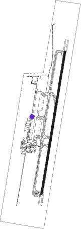
Eilat/ilan & Assaf Ramon
Airport details
| Country | Israel |
| State | South District |
| Region | LL |
| Airspace | Tel Aviv Ctr |
| Municipality | Eilat |
| Elevation | 288ft (88m) |
| Timezone | GMT +2 |
| Coordinates | 29.72709, 35.01410 |
| Magnetic var | |
| Type | land |
| Available since | X-Plane v10.40 |
| ICAO code | LLER |
| IATA code | n/a |
| FAA code | n/a |
Communication
| Eilat/Ilan & Assaf Ramon ATIS | 132.550 |
| Eilat/Ilan & Assaf Ramon Ground Control | 121.700 |
| Eilat/Ilan & Assaf Ramon Approach/Tower | 119.000 |
Approach frequencies
| ILS-cat-I | RW19 | 110.5 | 18.00mi |
| ILS-cat-I | RW01 | 108.7 | 18.00mi |
| 3° GS | RW19 | 110.5 | 18.00mi |
| 3° GS | RW01 | 108.7 | 18.00mi |
Runway info
| Runway 01 / 19 | ||
| length | 3604m (11824ft) | |
| bearing | 16° / 196° | |
| width | 45m (148ft) | |
| surface | asphalt | |
| blast zone | 255m (837ft) / 255m (837ft) | |
Nearby beacons
| code | identifier | dist | bearing | frequency |
|---|---|---|---|---|
| RAM | EILAT VOR/DME | 1.5 | 14° | 113.85 |
| LOT | EILOT VOR/DME | 7.4 | 198° | 112 |
| AQB | AQABA VOR/DME | 8.6 | 182° | 113.10 |
| AQC | KING HUSSEIN NDB | 11.8 | 31° | 326 |
| TBA | TABA VOR/DME | 13.4 | 241° | 114.50 |
| NWB | NUWEIBAA NDB | 45.4 | 206° | 288 |
| ZFR | ZOFAR VOR/DME | 50.5 | 10° | 115.60 |
Departure and arrival routes
| SID end points | distance | outbound heading | |
|---|---|---|---|
| RW01 | |||
| NURI1F, NURI1H | 21mi | 9° | |
| RW19 | |||
| NURI1J, NURI1K, NURI1M, NURI1N | 21mi | 9° | |
| STAR starting points | distance | inbound heading | |
|---|---|---|---|
| RW01 | |||
| NURI1B, NURI1D | 20.7 | 189° | |
Instrument approach procedures
| runway | airway (heading) | route (dist, bearing) |
|---|---|---|
| RW01-V | ESHEL (182°) | ESHEL 6000ft DUBIT (5mi, 210°) 5000ft ADIVI (2mi, 198°) 4600ft LIRAZ (5mi, 199°) 3200ft ELDAD (3mi, 101°) 1900ft |
| RNAV | ELDAD 1900ft LLER (6mi, 16°) 302ft ER127 (10mi, 14°) 3400ft NURIT (11mi, 4°) NURIT (turn) 10000ft | |
| RW01 | ADIVI (79°) | ADIVI 6000ft ER122 (9mi, 206°) 4000ft ER123 (3mi, 166°) 3700ft ER124 (3mi, 96°) 3400ft |
| RNAV | ER124 3400ft ER125 (5mi, 16°) 2400ft LLER (8mi, 16°) 302ft ER126 (5mi, 16°) ER127 (5mi, 12°) NURIT (11mi, 4°) 5000ft NURIT (turn) 10000ft | |
| RW19-V | NURIT (189°) | NURIT 5000ft ER012 (8mi, 186°) 3500ft ER007 (5mi, 186°) 2500ft YANIV (2mi, 186°) 1900ft |
| RNAV | YANIV 1900ft LLER (6mi, 196°) 321ft ER923 (11mi, 196°) 3000ft ADIVI (10mi, 0°) 5000ft ESHEL (7mi, 26°) 7000ft NURIT (15mi, 11°) 8000ft NURIT (turn) 10000ft | |
| RW19 | NURIT (189°) | NURIT 5000ft ER921 (8mi, 177°) 3600ft |
| RNAV | ER921 3600ft ER922 (5mi, 196°) 2500ft LLER (8mi, 196°) 322ft ER923 (11mi, 196°) ESHEL (16mi, 11°) 7000ft NURIT (15mi, 11°) 8000ft NURIT (turn) 10000ft |
Holding patterns
| STAR name | hold at | type | turn | heading* | altitude | leg | speed limit |
|---|---|---|---|---|---|---|---|
| NURI1B | ADIVI | VHF | right | 19 (199)° | 5000ft - 9000ft | DME 5.0mi | 185 |
| NURI1B | NURIT | VHF | right | 5 (185)° | 5000ft - 15000ft | 1.0min timed | 215 |
| NURI1D | NURIT | VHF | right | 5 (185)° | 5000ft - 15000ft | 1.0min timed | 215 |
| NURI1D | RAM | NDB | right | 5 (185)° | 6000ft - 9000ft | 1.0min timed | 185 |
| *) magnetic outbound (inbound) holding course | |||||||
Disclaimer
The information on this website is not for real aviation. Use this data with the X-Plane flight simulator only! Data taken with kind consent from X-Plane 12 source code and data files. Content is subject to change without notice.
