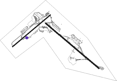
Luqa - La Valette Luqa
Airport details
| Country | Malta |
| State | Southern Region |
| Region | LM |
| Airspace | Malta Ctr |
| Municipality | Luqa |
| Elevation | 296ft (90m) |
| Timezone | GMT +1 |
| Coordinates | 35.85296, 14.48132 |
| Magnetic var | |
| Type | land |
| Available since | X-Plane v10.40 |
| ICAO code | LMML |
| IATA code | MLA |
| FAA code | n/a |
Communication
| La Valette Luqa ATIS | 127.400 |
| La Valette Luqa APRON | 133.900 |
| La Valette Luqa Tower | 135.100 |
| La Valette Luqa Approach | 128.150 |
Approach frequencies
| ILS-cat-I | RW31 | 110.5 | 18.00mi |
| ILS-cat-I | RW13 | 109.7 | 18.00mi |
| 3° GS | RW31 | 110.5 | 18.00mi |
| 3° GS | RW13 | 109.7 | 18.00mi |
Nearby beacons
| code | identifier | dist | bearing | frequency |
|---|---|---|---|---|
| MLT | MALTA NDB | 3.2 | 128° | 395 |
| GZO | GOZO VOR/DME | 17.4 | 304° | 115.70 |
Departure and arrival routes
| Transition altitude | 5000ft |
| Transition level | 7000ft |
| SID end points | distance | outbound heading | |
|---|---|---|---|
| RW05 | |||
| LORE2A | 67mi | 60° | |
| AGAR2A | 56mi | 84° | |
| GODA2A | 57mi | 101° | |
| SUDI2A | 27mi | 177° | |
| OBIT2A | 46mi | 268° | |
| GZO3A | 17mi | 304° | |
| RW13 | |||
| LORE2B | 67mi | 60° | |
| AGAR2B | 56mi | 84° | |
| GODA2B | 57mi | 101° | |
| SUDI2B | 27mi | 177° | |
| OBIT2B | 46mi | 268° | |
| GZO3B | 17mi | 304° | |
| RW23 | |||
| LORE2C | 67mi | 60° | |
| AGAR3C | 56mi | 84° | |
| GODA3C | 57mi | 101° | |
| SUDI2C | 27mi | 177° | |
| OBIT2C | 46mi | 268° | |
| GZO3C | 17mi | 304° | |
| RW31 | |||
| LORE2D | 67mi | 60° | |
| AGAR2D | 56mi | 84° | |
| GODA2D | 57mi | 101° | |
| SUDI2D | 27mi | 177° | |
| OBIT2D | 46mi | 268° | |
| GZO3D | 17mi | 304° | |
Instrument approach procedures
| runway | airway (heading) | route (dist, bearing) |
|---|---|---|
| RW05 | BEVIM (31°) | BEVIM 3000ft RALOM (3mi, 319°) 3000ft VEMOL (5mi, 319°) 3000ft |
| RW05 | METIM (86°) | METIM 3000ft LASGO (3mi, 139°) 3000ft VEMOL (5mi, 139°) 3000ft |
| RW05 | VEKIM (60°) | VEKIM 3000ft VEMOL (11mi, 60°) 3000ft |
| RNAV | VEMOL 3000ft VEBIK (5mi, 60°) 3000ft LMML (9mi, 62°) 346ft (2300mi, 202°) 2000ft ML001 (2310mi, 22°) 3000ft (2310mi, 202°) | |
| RW13 | GUDER (162°) | GUDER 3000ft LAKOM (3mi, 231°) 3000ft NEDOX (5mi, 231°) 3000ft |
| RW13 | NOLER (129°) | NOLER 3000ft NEDOX (11mi, 129°) 3000ft |
| RW13 | OMBER (102°) | OMBER 3000ft RANAT (3mi, 50°) 3000ft NEDOX (5mi, 51°) 3000ft |
| RNAV | NEDOX 3000ft NEBEN (5mi, 129°) 3000ft LMML (9mi, 129°) 305ft (2300mi, 202°) 2000ft ML101 (2296mi, 22°) 3000ft (2296mi, 202°) | |
| RW23 | EVLAM (239°) | EVLAM 3000ft EVOTA (11mi, 240°) 3000ft |
| RW23 | INTAM (265°) | INTAM 3000ft LAPID (3mi, 319°) 3000ft EVOTA (5mi, 319°) 3000ft |
| RW23 | MONAM (208°) | MONAM 3000ft REVPO (3mi, 139°) 3000ft EVOTA (5mi, 139°) 3000ft |
| RNAV | EVOTA 3000ft EVPAT (5mi, 240°) 3000ft LMML (9mi, 238°) 295ft (2300mi, 202°) 2000ft ML201 (2290mi, 22°) 3000ft (2290mi, 202°) | |
| RW31-V | LONIK (17°) | LONIK 3000ft DEMIX (4mi, 129°) 3000ft ENELO (5mi, 51°) 2000ft |
| RW31-V | ROTIP (257°) | ROTIP 3000ft SUNER (4mi, 129°) 3000ft ENELO (5mi, 231°) 2000ft |
| RNAV | ENELO 2000ft ML361 (2mi, 309°) 1430ft LMML (5mi, 308°) 281ft D312J (9mi, 309°) 3000ft TIVOR (25mi, 148°) 3000ft | |
| RW31 | KEKOR (284°) | KEKOR 3000ft RULOV (3mi, 231°) 3000ft SUDOX (5mi, 231°) 3000ft |
| RW31 | SOFOR (309°) | SOFOR 3000ft SUDOX (11mi, 309°) 3000ft |
| RW31 | TIVOR (339°) | TIVOR 3000ft LUVOS (3mi, 51°) 3000ft SUDOX (5mi, 51°) 3000ft |
| RNAV | SUDOX 3000ft SUKAL (5mi, 309°) 3000ft LMML (10mi, 309°) 281ft (2300mi, 202°) 2000ft ML301 (2304mi, 22°) 3000ft (2304mi, 202°) |
Disclaimer
The information on this website is not for real aviation. Use this data with the X-Plane flight simulator only! Data taken with kind consent from X-Plane 12 source code and data files. Content is subject to change without notice.

