Airports for X-Plane offers a convenient way to explore airports and their related communication information for the X-Plane flight simulator. It only uses data from the X-Plane flight simulator itself, and is therefore more reliable than the data that comes from real aviation websites. You can search for airports by using the ICAO code, or browse for airports per country and state. The information displayed is categorized by airport details, runway information, airport communication, approach frequencies (ILS and Glidepath details), details of nearby beacons, SIDs, STARs and approach procedures.

city frankfurt airport airport passengers plane airport authority regional hotel port helipad nearby traffic corporation consulate customs buildings airborne bus air traffic control field

Dobersberg

Airport details

CountryAustria
StateLower Austria
RegionLO
AirspaceVienna Ctr
MunicipalityDobersberg
Elevation1720ft (524m)
TimezoneGMT +1
Coordinates48.92222, 15.29694
Magnetic var
Typeland
Available sinceX-Plane v10.40
ICAO codeLOAB
IATA coden/a
FAA coden/a

Communication

Dobersberg Dobersberg Flugplatz122.505
Nearby Points of Interest:
Schloss Illmau
-
Kath. Pfarrkirche hl. Bartholomäus
-
Wehrkirche Kleinzwettl
-
Zámek Dobrohoř
-
Chapel of the Holy Cross
-
Chapel of Saint John of Nepomuk
-
Synagogue in Slavonice
-
City walls of Slavonice
-
Pfarrkirche Puch, Waidhofen an der Thaya
-
Stations of the Cross in Slavonice
-
City wall, Waidhofen a. d. Thaya
-
Ortskapelle Leopoldsdorf
-
Friedhof, jüdisch in Waidhofen an der Thaya
-
Jewish cemetery in Písečné
-
Kostel Panny Marie Bolestné
-
Pfarrkirche Buchbach
-
Rathaus Weikertschlag an der Thaya
-
Klafferkapelle
-
Jewish cemetery in Dolní Bolíkov
-
Hängender Stein
-
Church of Saints Peter and Paul
-
Stadtpfarrkirche Heidenreichstein
-
Kollegiatstift Eisgarn
-
Saint John the Baptist Church
-
Church of the Assumption

Runway info

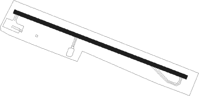
Runway 12 / 30
 length841m (2759ft)
 bearing107° / 287°
 width18m (59ft)
 surfaceasphalt

Airport layout


Parking locations

Nearby beacons

codeidentifierdistbearingfrequency
OKFDESNA VOR/DME10.279°113.15
XUNAMEST NDB34.570°563
XNAMEST NDB35.172°362
LNAMEST NDB36.475°362
LANAMEST NDB3776°514
VOZVOZICE VOR/DME40.2325°116.95
STOSTOCKERAU VOR/DME41.7125°113
TUNTULLN NDB45.7132°358
VLMVLASIM VOR/DME47.8344°114.30
LNZLINZ NDB56.5235°327
STESTEINHOF NDB57127°293
CFCASLAV NDB59.2345

Disclaimer

The information on this website is not for real aviation. Use this data with the X-Plane flight simulator only! Data taken with kind consent from X-Plane 12 source code and data files. Content is subject to change without notice.