Bad Vöslau - Voeslau
Airport details
| Country | Austria |
| State | Lower Austria |
| Region | LO |
| Airspace | Vienna Ctr |
| Municipality | Kottingbrunn |
| Elevation | 765ft (233m) |
| Timezone | GMT +1 |
| Coordinates | 47.96523, 16.25635 |
| Magnetic var | |
| Type | land |
| Available since | X-Plane v10.40 |
| ICAO code | LOAV |
| IATA code | n/a |
| FAA code | n/a |
Communication
| Voeslau Voslau | 118.600 |
Nearby Points of Interest:
Parish church in Kottingbrunn
-Spinnerei Teesdorf
-Schloss Vöslau
-Naturdenkmal Hansybach
-Cafe Thermalbad, Bad Vöslau
-Thermalbad, Bad Vöslau
-Martinekkaserne
-Church Tribuswinkel
-Josefsbad, Baden, Lower Austria
-Pfarrkirche hl. Jakobus der Ältere, Oberwaltersdorf
-Baden bei Wien
-Kaiserhaus
-Dreifaltigkeitssäule, Baden
-Bürgerspital Baden, Lower Austria
-Beethoven-Haus
-Pfarrkirche hl. Martin, Leobersdorf
-Grüner Markt
-Synagoge (Oberwaltersdorf)
-Palais Erzherzog Anton
-Mathildenhof (Baden)
-Gasthaus zum goldenen Kreuz
-Leopoldsbad
-Haus der Kunst
-Villa Hahn
-Schloss Weikersdorf
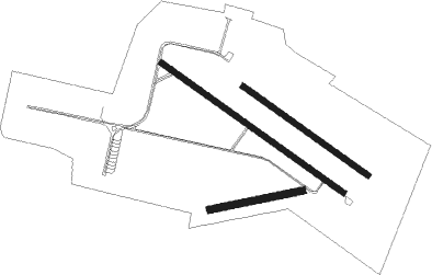
Runway info
Runway 08 / 26  | ||
| length | 400m (1312ft) | |
| bearing | 85° / 265° | |
| width | 30m (98ft) | |
| surface | grass | |
| Runway 13L / 31R | ||
| length | 651m (2136ft) | |
| bearing | 119° / 299° | |
| width | 25m (82ft) | |
| surface | grass | |
| Runway 13R / 31L | ||
| length | 949m (3114ft) | |
| bearing | 119° / 299° | |
| width | 23m (75ft) | |
| surface | asphalt | |
| blast zone | 0m (0ft) / 55m (180ft) | |
Nearby beacons
| code | identifier | dist | bearing | frequency |
|---|---|---|---|---|
| SNU | SOLLENAU VOR/DME | 5.5 | 160° | 115.50 |
| STE | STEINHOF NDB | 14.7 | 358° | 293 |
| FMD | FISCHAMEND VOR/DME | 17.1 | 69° | 110.40 |
| BRK | BRUCK NDB | 19.4 | 78° | 408 |
| TUN | TULLN NDB | 23.4 | 321° | 358 |
| WGM | WAGRAM VOR/DME | 23.5 | 33° | 112.20 |
| STO | STOCKERAU VOR/DME | 28.7 | 332° | 113 |
| B | BARKA (BRATISLAVA) NDB | 41.1 | 79° | 438 |
| RAW | DME | 45.4 | 215° | 112.15 |
Instrument approach procedures
| runway | airway (heading) | route (dist, bearing) |
|---|---|---|
| RWNVA | MOVOS (287°) | MOVOS 3000ft AV806 (2mi, 284°) 3000ft |
| RNAV | AV806 3000ft AV807 (4mi, 284°) 1580ft MOVOS (5mi, 104°) 3000ft MOVOS (turn) |
Disclaimer
The information on this website is not for real aviation. Use this data with the X-Plane flight simulator only! Data taken with kind consent from X-Plane 12 source code and data files. Content is subject to change without notice.