Airports for X-Plane offers a convenient way to explore airports and their related communication information for the X-Plane flight simulator. It only uses data from the X-Plane flight simulator itself, and is therefore more reliable than the data that comes from real aviation websites. You can search for airports by using the ICAO code, or browse for airports per country and state. The information displayed is categorized by airport details, runway information, airport communication, approach frequencies (ILS and Glidepath details), details of nearby beacons, SIDs, STARs and approach procedures.

drome transit downtown pilot airplane near airspace taxiway airstrip flight attendant flown air safety gravel automated airport weather station seaplanes helicopters international airport capital grass commuter

Bad Vöslau - Voeslau

Airport details

CountryAustria
StateLower Austria
RegionLO
AirspaceVienna Ctr
MunicipalityKottingbrunn
Elevation765ft (233m)
TimezoneGMT +1
Coordinates47.96523, 16.25635
Magnetic var
Typeland
Available sinceX-Plane v10.40
ICAO codeLOAV
IATA coden/a
FAA coden/a

Communication

Voeslau Voslau118.600
Nearby Points of Interest:
Parish church in Kottingbrunn
-
Spinnerei Teesdorf
-
Schloss Vöslau
-
Naturdenkmal Hansybach
-
Cafe Thermalbad, Bad Vöslau
-
Thermalbad, Bad Vöslau
-
Martinekkaserne
-
Church Tribuswinkel
-
Josefsbad, Baden, Lower Austria
-
Pfarrkirche hl. Jakobus der Ältere, Oberwaltersdorf
-
Baden bei Wien
-
Kaiserhaus
-
Dreifaltigkeitssäule, Baden
-
Bürgerspital Baden, Lower Austria
-
Beethoven-Haus
-
Pfarrkirche hl. Martin, Leobersdorf
-
Grüner Markt
-
Synagoge (Oberwaltersdorf)
-
Palais Erzherzog Anton
-
Mathildenhof (Baden)
-
Gasthaus zum goldenen Kreuz
-
Leopoldsbad
-
Haus der Kunst
-
Villa Hahn
-
Schloss Weikersdorf

Runway info

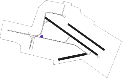
Runway 08 / 26  
 length400m (1312ft)
 bearing85° / 265°
 width30m (98ft)
 surfacegrass
Runway 13L / 31R  
 length651m (2136ft)
 bearing119° / 299°
 width25m (82ft)
 surfacegrass
Runway 13R / 31L  
 length949m (3114ft)
 bearing119° / 299°
 width23m (75ft)
 surfaceasphalt
 blast zone0m (0ft) / 55m (180ft)

Airport layout - taxiway location C


Taxiway locations
Parking locations

Nearby beacons

codeidentifierdistbearingfrequency
SNUSOLLENAU VOR/DME5.5160°115.50
STESTEINHOF NDB14.7358°293
FMDFISCHAMEND VOR/DME17.169°110.40
BRKBRUCK NDB19.478°408
TUNTULLN NDB23.4321°358
WGMWAGRAM VOR/DME23.533°112.20
STOSTOCKERAU VOR/DME28.7332°113
BBARKA (BRATISLAVA) NDB41.179°438
RAWDME45.4215°112.15

Instrument approach procedures

runwayairway (heading)route (dist, bearing)
RWNVAMOVOS (287°)MOVOS 3000ft
AV806 (2mi, 284°) 3000ft
 RNAVAV806 3000ft
AV807 (4mi, 284°) 1580ft
MOVOS (5mi, 104°) 3000ft
MOVOS (turn)

Disclaimer

The information on this website is not for real aviation. Use this data with the X-Plane flight simulator only! Data taken with kind consent from X-Plane 12 source code and data files. Content is subject to change without notice.