Wels
Airport details
| Country | Austria |
| State | Upper Austria |
| Region | LO |
| Airspace | Vienna Ctr |
| Municipality | Wels |
| Elevation | 1041ft (317m) |
| Timezone | GMT +1 |
| Coordinates | 48.17824, 14.03851 |
| Magnetic var | |
| Type | land |
| Available since | X-Plane v10.40 |
| ICAO code | LOLW |
| IATA code | n/a |
| FAA code | n/a |
Communication
| Wels Wels Flugplatz | 119.705 |
Nearby Points of Interest:
Jüdischer bzw. KZ-Friedhof
-Stadtfriedhof Wels
-Pfarrkirche Wels-Pernau
-Pfarrkirche Wels-Heilige Familie
-Dragonerkaserne Wels
-Sankt Jakob
-Sankt Vitus
-Pfarrkirche Krenglbach
-Pfarrkirche Mariä Himmelfahrt
-Schloss Mistelbach
-Schloss Steinhaus
-Katholische Pfarrkirche Wallern an der Trattnach
-Evangelische Pfarrkirche Wallern an der Trattnach
-Sankt Georgen im Schauertal
-Gunskirchen-Wels I concentration camp
-Sankt Michael
-Sankt Petrus
-Pfarrkirche Hörsching
-Sankt Leonhard
-Benediktinerinnenkloster Steinerkirchen
-Vogler Aerodrome
-Schloss Schlüßlberg
-Schloss Breitenau
-Pfarr- und Wallfahrtskirche Maria Rast
-Evang. Pfarrkirche A.B.
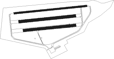
Runway info
Runway 08L / 26R  | ||
| length | 1216m (3990ft) | |
| bearing | 89° / 269° | |
| width | 30m (98ft) | |
| surface | asphalt | |
| displ threshold | 110m (361ft) / 0m (0ft) | |
| blast zone | 105m (344ft) / 76m (249ft) | |
| Runway 08C / 26C | ||
| length | 923m (3028ft) | |
| bearing | 89° / 269° | |
| width | 50m (164ft) | |
| surface | grass | |
| Runway 08R / 26L | ||
| length | 855m (2805ft) | |
| bearing | 89° / 269° | |
| width | 45m (148ft) | |
| surface | grass | |
| displ threshold | 0m (0ft) / 99m (325ft) | |
Nearby beacons
| code | identifier | dist | bearing | frequency |
|---|---|---|---|---|
| LNZ | LINZ VOR/DME | 4 | 51° | 116.60 |
| LNZ | LINZ NDB | 11.8 | 78° | 327 |
| FRE | DME | 15.6 | 20° | 113.50 |
| GSB | DME | 43.4 | 248° | 109.45 |
| ZW | ZELTWEG NDB | 65.6 | 144° | 418 |
Disclaimer
The information on this website is not for real aviation. Use this data with the X-Plane flight simulator only! Data taken with kind consent from X-Plane 12 source code and data files. Content is subject to change without notice.