Graz - Graz Thalerhof
Airport details
| Country | Austria |
| State | Styria |
| Region | LO |
| Airspace | Vienna Ctr |
| Municipality | Feldkirchen bei Graz |
| Elevation | 1115ft (340m) |
| Timezone | GMT +1 |
| Coordinates | 46.99342, 15.44403 |
| Magnetic var | |
| Type | land |
| Available since | X-Plane v10.40 |
| ICAO code | LOWG |
| IATA code | GRZ |
| FAA code | n/a |
Communication
| Graz Thalerhof ATIS | 126.125 |
| Graz Thalerhof Tower | 118.200 |
| Graz Thalerhof Approach | 123.025 |
| Graz Thalerhof Approach | 119.300 |
| Graz Thalerhof Departure | 118.200 |
Approach frequencies
| ILS-cat-III | RW34C | 110.9 | 18.00mi |
| 3° GS | RW34C | 110.9 | 18.00mi |
Nearby Points of Interest:
Florianikapelle
-Pfarrhof Straßgang
-Brückenwaage (Fernitz)
-Schloss Liebenau
-Landesnervenklinik Sigmund Freud
-Seifenfabrik Graz
-Ansitz Hochkofler
-Justizanstalt Graz-Karlau
-Anlage Land- und forstwirtschaftliche Fachschule Grottenhof, ehem. Alt-Grottenhof
-Criminal Court Graz
-Gruabn
-Belgier-Kaserne, Wetzelsdorf
-Alte Post
-Landesgericht für Zivilrechtssachen Graz
-Kriegerkapelle Wetzelsdorf
-Palais Kollonitsch, Graz
-Palais Welsersheimb, Graz
-Lindenhaus
-Palais Lengheimb
-Palais Stubenberg, Graz
-Landhaus, Graz
-Bischöfliches Palais, Graz
-Palais Breuner, Graz
-Palais Inzaghi
-Palais Katzianer, Graz
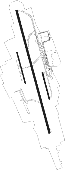
Runway info
Runway 17C / 35C  | ||
| length | 3003m (9852ft) | |
| bearing | 165° / 345° | |
| width | 45m (148ft) | |
| surface | asphalt | |
| displ threshold | 260m (853ft) / 0m (0ft) | |
| blast zone | 30m (98ft) / 0m (0ft) | |
| Runway 17R / 35L | ||
| length | 761m (2497ft) | |
| bearing | 165° / 345° | |
| width | 25m (82ft) | |
| surface | grass | |
| displ threshold | 150m (492ft) / 0m (0ft) | |
| Runway 17L / 35R | ||
| length | 641m (2103ft) | |
| bearing | 165° / 345° | |
| width | 30m (98ft) | |
| surface | grass | |
Nearby beacons
| code | identifier | dist | bearing | frequency |
|---|---|---|---|---|
| GRZ | GRAZ VOR/DME | 2.2 | 172° | 116.20 |
| GRZ | GRAZ NDB | 4.4 | 168° | 290 |
| GBG | GLEICHENBERG NDB | 15.9 | 107° | 426 |
| RAW | DME | 21.9 | 49° | 112.15 |
| STK | KOGEL DME | 21.9 | 107° | 114.55 |
| KOR | DME | 23 | 246° | 109.40 |
| ZW | ZELTWEG NDB | 30.6 | 287° | 418 |
| MI | OREHOVA VAS (MARIBOR) NDB | 33.6 | 154° | 355 |
| MR | MARIBOR NDB | 40 | 151° | 334 |
| KFT | KLAGENFURT VOR/DME | 43.3 | 246° | 113.10 |
| KFT | KLAGENFURT NDB | 43.4 | 248° | 374 |
| VAR | VARAZDIN NDB | 56.1 | 126° | 344 |
| DOL | DOLSKO VOR/DME | 61.1 | 216° | 112.70 |
| MG | LJUBLJANA NDB | 61.4 | 227° | 296 |
| SNU | SOLLENAU VOR/DME | 63 | 44° | 115.50 |
Departure and arrival routes
| Transition altitude | 4000ft |
| SID end points | distance | outbound heading | |
|---|---|---|---|
| RW16C | |||
| ROPA4G | 20mi | 58° | |
| GOTA5G | 32mi | 90° | |
| GBG7X | 16mi | 107° | |
| MURE5G | 23mi | 128° | |
| GOLV5G | 19mi | 144° | |
| RADL5G | 23mi | 214° | |
| ABIR4G | 24mi | 244° | |
| MILG3H, MILG6G | 23mi | 311° | |
| RW34C | |||
| ROPA4U | 20mi | 58° | |
| GOTA5U | 32mi | 90° | |
| GBG5Y | 16mi | 107° | |
| MURE4U | 23mi | 128° | |
| GOLV4U | 19mi | 144° | |
| RADL4V, RADL6U | 23mi | 214° | |
| ABIR5U, ABIR3V | 24mi | 244° | |
| MILG5U | 23mi | 311° | |
| STAR starting points | distance | inbound heading | |
|---|---|---|---|
| ALL | |||
| RADL2M | 22.9 | 34° | |
| ABIR1M | 23.9 | 64° | |
| LEOB1M | 28.0 | 132° | |
| RUPE2M | 30.6 | 211° | |
| GOTA2M | 31.9 | 270° | |
| MURE1M | 22.8 | 308° | |
| GOLV1M | 19.1 | 324° | |
Instrument approach procedures
| runway | airway (heading) | route (dist, bearing) |
|---|---|---|
| RW16C | PIB2N (18°) | PIBIP WG501 (9mi, 345°) WG822 (15mi, 344°) 7500ft RONOT (5mi, 263°) 7500ft |
| RW16C | WG821 (145°) | WG821 8000ft RONOT (5mi, 83°) 7500ft |
| RW16C | WG822 (185°) | WG822 7500ft RONOT (5mi, 263°) 7500ft |
| RW16C | XIB2N (18°) | XIBAR WG821 (24mi, 345°) 8000ft RONOT (5mi, 83°) 7500ft |
| RNAV | RONOT 7500ft WG814 (6mi, 164°) 5500ft WG815 (3mi, 164°) 4700ft WG816 (2mi, 165°) 4000ft WG817 (2mi, 165°) 3300ft LOWG (6mi, 162°) 1167ft (2936mi, 198°) 2500ft GBG (2936mi, 19°) 5000ft GBG (turn) 5000ft | |
| RW34C | PIB2S (18°) | PIBIP 3500ft WG833 (8mi, 168°) 3500ft VAGIL (5mi, 276°) 3500ft |
| RW34C | WG832 (16°) | WG832 3500ft VAGIL (5mi, 68°) 3500ft |
| RW34C | WG833 (319°) | WG833 3500ft VAGIL (5mi, 276°) 3500ft |
| RW34C | XIB2S (18°) | XIBAR 7500ft WG832 (8mi, 161°) 3500ft VAGIL (5mi, 68°) 3500ft |
| RNAV | VAGIL 3500ft WG835 (4mi, 345°) 3000ft LOWG (7mi, 347°) 1141ft WG836 (turn) GBG (17mi, 109°) 5000ft GBG (turn) 5000ft |
Holding patterns
| STAR name | hold at | type | turn | heading* | altitude | leg | speed limit |
|---|---|---|---|---|---|---|---|
| ABIR1M | XIBAR | VHF | left | 254 (74)° | > 7500ft | 1.0min timed | 200 |
| GBG1M | PIBIP | VHF | right | 78 (258)° | > 3000ft | 1.0min timed | 120 |
| GOLV1M | PIBIP | VHF | right | 78 (258)° | > 3000ft | 1.0min timed | 120 |
| GOTA2M | PIBIP | VHF | right | 78 (258)° | > 3000ft | 1.0min timed | 120 |
| LEOB1M | XIBAR | VHF | left | 254 (74)° | > 7500ft | 1.0min timed | 200 |
| MURE1M | PIBIP | VHF | right | 78 (258)° | > 3000ft | 1.0min timed | 120 |
| RADL2M | XIBAR | VHF | left | 254 (74)° | > 7500ft | 1.0min timed | 200 |
| RUPE2M | PIBIP | VHF | right | 78 (258)° | > 3000ft | 1.0min timed | 120 |
| *) magnetic outbound (inbound) holding course | |||||||
Disclaimer
The information on this website is not for real aviation. Use this data with the X-Plane flight simulator only! Data taken with kind consent from X-Plane 12 source code and data files. Content is subject to change without notice.