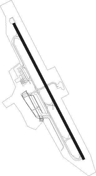
Salzburg - Salzburg Maxglan
Airport details
| Country | Austria |
| State | Salzburg |
| Region | LO |
| Airspace | Vienna Ctr |
| Elevation | 1411ft (430m) |
| Timezone | GMT +1 |
| Coordinates | 47.79598, 12.99777 |
| Magnetic var | |
| Type | land |
| Available since | X-Plane v10.40 |
| ICAO code | LOWS |
| IATA code | SZG |
| FAA code | n/a |
Communication
| Salzburg Maxglan ATIS | 133.330 |
| Salzburg Maxglan Ground Control | 121.750 |
| Salzburg Maxglan Tower | 118.100 |
| Salzburg Maxglan Departure | 123.725 |
Approach frequencies
| ILS-cat-III | RW15 | 109.9 | 18.00mi |
| 3° GS | RW15 | 109.9 | 18.00mi |
Nearby Points of Interest:
Römische Villa Loig
-Pfarrkirche Maxglan
-Church of the Nativity of the Virgin Mary
-Johannsspitalkirche
-Lürzerhof
-Pfarrkirche zum heiligen Georg
-Schloss Schönleiten
-University Hospital Salzburg
-Herz-Jesu-Asylkirche
-Müllegger Tor, Salzburg
-Johannesschlössl
-Marketenderschlössl
-Literaturhaus Salzburg
-USFA Wohnhaussiedlung General-Keyes-Straße
-Augustiner Bräu Kloster Mülln Salzburg
-Pfarrkirche Mülln
-Sigmundstor
-Schlossbauerngut
-Altstadt (Salzburg)
-Kupelwieser-Schlössl, Salzburg
-Grasmayr-Villa
-Lehen parish church
-Edmundsburg
-Alte Universität
-Freyschlössl
Runway info
| Runway 15 / 33 | ||
| length | 2747m (9012ft) | |
| bearing | 148° / 328° | |
| width | 45m (148ft) | |
| surface | concrete | |
| displ threshold | 198m (650ft) / 240m (787ft) | |
| blast zone | 125m (410ft) / 0m (0ft) | |
Nearby beacons
| code | identifier | dist | bearing | frequency |
|---|---|---|---|---|
| SI | SALZBURG NDB | 1.4 | 336° | 410 |
| GSB | DME | 4.6 | 85° | 109.45 |
| SBG | SALZBURG NDB | 11.1 | 329° | 382 |
| SBG | SALZBURG VOR/DME | 13.1 | 333° | 113.80 |
Departure and arrival routes
| Transition altitude | 6000ft |
| SID end points | distance | outbound heading | |
|---|---|---|---|
| RW15 | |||
| INRO1B, INRO1X | 15mi | 42° | |
| NEMA3B | 21mi | 76° | |
| VERD1Y, VERD2B, VERD1X | 21mi | 128° | |
| DETS2B | 66mi | 216° | |
| RTT4B | 48mi | 251° | |
| TRAU8V, TRAU3B, TRAU1X | 20mi | 294° | |
| TITI3B | 24mi | 301° | |
| RW33 | |||
| INRO1A, INRO1S | 15mi | 42° | |
| NEMA3A | 21mi | 76° | |
| VERD1A | 21mi | 128° | |
| DETS1A | 66mi | 216° | |
| RTT3A | 48mi | 251° | |
| TRAU2A, TRAU7S | 20mi | 294° | |
| TITI2A | 24mi | 301° | |
| SBG1S, SBG2A | 11mi | 329° | |
| STAR starting points | distance | inbound heading | |
|---|---|---|---|
| ALL | |||
| UNKE1R | 16.0 | 94° | |
| TRAU1R | 19.7 | 114° | |
| TITI1R | 23.6 | 121° | |
| BADI1R | 23.0 | 156° | |
| MATI1R | 26.9 | 244° | |
| NUBR2R | 38.0 | 273° | |
| RAST1R | 23.8 | 308° | |
Instrument approach procedures
| runway | airway (heading) | route (dist, bearing) |
|---|---|---|
| RW15-E | WS813 (125°) | WS813 5000ft WS815 (5mi, 74°) 4000ft WS816 (5mi, 148°) 4000ft |
| RW15-E | WS814 (178°) | WS814 5000ft WS815 (5mi, 254°) 4000ft WS816 (5mi, 148°) 4000ft |
| RW15-E | WS815 (149°) | WS815 4000ft WS816 (5mi, 148°) 4000ft |
| RNAV | WS816 4000ft LOWS (8752mi, 123°) 1467ft WS818 (8748mi, 302°) WS815 (15mi, 328°) 6000ft WS815 (turn) | |
| RW15-X | WS813 (125°) | WS813 5000ft WS815 (5mi, 74°) 4000ft WS816 (5mi, 148°) 4000ft |
| RW15-X | WS814 (178°) | WS814 5000ft WS815 (5mi, 254°) 4000ft WS816 (5mi, 148°) 4000ft |
| RW15-X | WS815 (149°) | WS815 4000ft WS816 (5mi, 148°) 4000ft |
| RNAV | WS816 4000ft WS817 (4mi, 148°) 2659ft (2953mi, 195°) 2659ft WS815 (2960mi, 15°) 6000ft WS815 (turn) | |
| RW33-V | WS831 (151°) | WS831 5000ft WS833 (5mi, 96°) 5000ft |
| RW33-V | WS832 (208°) | WS832 5000ft WS833 (5mi, 248°) 5000ft |
| RNAV | WS833 5000ft WS834 (6mi, 163°) 5000ft WS835 (3mi, 163°) 3980ft WS831 (12mi, 314°) 6000ft WS831 (turn) | |
| RW33-Y | WS831 (151°) | WS831 5000ft WS833 (5mi, 96°) 5000ft |
| RW33-Y | WS832 (208°) | WS832 5000ft WS833 (5mi, 248°) 5000ft |
| RNAV | WS833 5000ft WS834 (6mi, 163°) 5000ft WS836 (6mi, 163°) WS837 (2mi, 258°) LOWS (8747mi, 122°) 1461ft WS831 (8753mi, 303°) 6000ft WS831 (turn) | |
| RW33-Z | ETROK (304°) | ETROK 10000ft WS806 (7mi, 286°) 7400ft WS805 (5mi, 310°) 5500ft |
| RW33-Z | KONUG (338°) | KONUG 11500ft WS811 (3mi, 358°) 10500ft WS810 (3mi, 358°) 9500ft WS809 (3mi, 358°) 8500ft WS808 (2mi, 18°) 7900ft WS807 (4mi, 350°) 6500ft WS805 (3mi, 344°) 5500ft |
| RNAV | WS805 5500ft WS804 (4mi, 332°) 4000ft WS803 (2mi, 308°) WS802 (1mi, 289°) WS801 (turn) WS800 (turn) LOWS (8747mi, 122°) 1461ft WS823 (8752mi, 303°) SBG (turn) 6000ft SBG (turn) 6000ft |
Holding patterns
| STAR name | hold at | type | turn | heading* | altitude | leg | speed limit |
|---|---|---|---|---|---|---|---|
| BADI1R | SBG | NDB | left | 355 (175)° | > 4000ft | 1.0min timed | ICAO rules |
| MATI1R | SBG | NDB | left | 355 (175)° | > 4000ft | 1.0min timed | ICAO rules |
| NUBR2R | SBG | NDB | left | 355 (175)° | > 4000ft | 1.0min timed | ICAO rules |
| RAST1R | SBG | NDB | left | 355 (175)° | > 4000ft | 1.0min timed | ICAO rules |
| TITI1R | SBG | NDB | left | 355 (175)° | > 4000ft | 1.0min timed | ICAO rules |
| TRAU1R | SBG | NDB | left | 355 (175)° | > 4000ft | 1.0min timed | ICAO rules |
| UNKE1R | SBG | NDB | left | 355 (175)° | > 4000ft | 1.0min timed | ICAO rules |
| *) magnetic outbound (inbound) holding course | |||||||
Disclaimer
The information on this website is not for real aviation. Use this data with the X-Plane flight simulator only! Data taken with kind consent from X-Plane 12 source code and data files. Content is subject to change without notice.