Zell Am See
Airport details
| Country | Austria |
| State | Salzburg |
| Region | LO |
| Airspace | Vienna Ctr |
| Municipality | Zell am See |
| Elevation | 2470ft (753m) |
| Timezone | GMT +1 |
| Coordinates | 47.29222, 12.78750 |
| Magnetic var | |
| Type | land |
| Available since | X-Plane v10.40 |
| ICAO code | LOWZ |
| IATA code | n/a |
| FAA code | n/a |
Communication
Nearby Points of Interest:
Vogtturm
-Franziskanerkloster St. Anton, Pinzgau, Bruck
-Schloss Priela
-Heuberg Castle
-Castle Saalhof
-Schloss Kammer
-Ansitz Penninghof, Taxenbach
-Burgruine Taxenbach
-Edtgut, Taxenbach
-Schloss Farmach
-Pfarrkirche
-Wartturm, Saalbach
-Pfarrkirche hll. Bartholomäus und Nikolaus, Saalbach
-Pfarrkirche hl. Nikolaus, Dienten
-Saueckkapelle
-Schloss Labach
-Burgruine Saalegg
-Widum Fieberbrunn
-Pfarrhof Sankt Veit im Pongau
-Veitskirche
-Seelackenmuseum
-Pfarrkirche hl. Rupert, Aurach bei Kitzbühel
-Apriacher Stockmühlen
-Arthurstollen
-Kirchenruine St. Peter
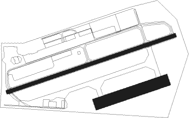
Runway info
Runway 08 / 26  | ||
| length | 780m (2559ft) | |
| bearing | 80° / 260° | |
| width | 18m (59ft) | |
| surface | asphalt | |
| displ threshold | 125m (410ft) / 120m (394ft) | |
| Runway 08R / 26L | ||
| length | 300m (984ft) | |
| bearing | 80° / 260° | |
| width | 50m (164ft) | |
| surface | grass | |
Nearby beacons
| code | identifier | dist | bearing | frequency |
|---|---|---|---|---|
| SI | SALZBURG NDB | 32.6 | 21° | 410 |
| GSB | DME | 33.4 | 32° | 109.45 |
| RTT | RATTENBERG NDB | 35.4 | 279° | 303 |
| SBG | SALZBURG NDB | 40.7 | 9° | 382 |
| SBG | SALZBURG VOR/DME | 42.8 | 8° | 113.80 |
| OTT | OTTERSBERG VOR/DME | 66.2 | 312° | 112.30 |
Departure and arrival routes
| SID end points | distance | outbound heading | |
|---|---|---|---|
| ALL | |||
| NANI1G | 19mi | 283° | |
Instrument approach procedures
| runway | airway (heading) | route (dist, bearing) |
|---|---|---|
| RWNVA | NANIT (103°) | NANIT 10000ft WZ801 (6mi, 151°) 8500ft WZ802 (6mi, 100°) 7200ft |
| RNAV | WZ802 7200ft WZ803 (6mi, 87°) 4690ft (2917mi, 195°) 7500ft NANIT (2919mi, 15°) 10000ft NANIT (turn) 10000ft |
Disclaimer
The information on this website is not for real aviation. Use this data with the X-Plane flight simulator only! Data taken with kind consent from X-Plane 12 source code and data files. Content is subject to change without notice.