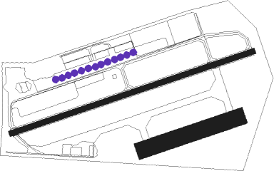
Airports for X-Plane offers a convenient way to explore airports and their related communication information for the X-Plane flight simulator. It only uses data from the X-Plane flight simulator itself, and is therefore more reliable than the data that comes from real aviation websites. You can search for airports by using the ICAO code, or browse for airports per country and state. The information displayed is categorized by airport details, runway information, airport communication, approach frequencies (ILS and Glidepath details), details of nearby beacons, SIDs, STARs and approach procedures.

regional hospital airline stol passenger flight airport airport terminal passengers aviation air traffic control asphalt downtown taxi tarmac non-towered airport airport authority airfield traffic pattern airport check-in airplane

Zell Am See

Airport details

CountryAustria
StateSalzburg
RegionLO
AirspaceVienna Ctr
MunicipalityZell am See
Elevation2470ft (753m)
TimezoneGMT +1
Coordinates47.29222, 12.78750
Magnetic var
Typeland
Available sinceX-Plane v10.40
ICAO codeLOWZ
IATA coden/a
FAA coden/a

Communication

No airport communication available for LOWZ
Nearby Points of Interest:
Vogtturm
-
Franziskanerkloster St. Anton, Pinzgau, Bruck
-
Schloss Priela
-
Heuberg Castle
-
Castle Saalhof
-
Schloss Kammer
-
Ansitz Penninghof, Taxenbach
-
Burgruine Taxenbach
-
Edtgut, Taxenbach
-
Schloss Farmach
-
Pfarrkirche
-
Wartturm, Saalbach
-
Pfarrkirche hll. Bartholomäus und Nikolaus, Saalbach
-
Pfarrkirche hl. Nikolaus, Dienten
-
Saueckkapelle
-
Schloss Labach
-
Burgruine Saalegg
-
Widum Fieberbrunn
-
Pfarrhof Sankt Veit im Pongau
-
Veitskirche
-
Seelackenmuseum
-
Pfarrkirche hl. Rupert, Aurach bei Kitzbühel
-
Apriacher Stockmühlen
-
Arthurstollen
-
Kirchenruine St. Peter

Runway info

Runway 08 / 26  
 length780m (2559ft)
 bearing80° / 260°
 width18m (59ft)
 surfaceasphalt
 displ threshold125m (410ft) / 120m (394ft)
Runway 08R / 26L  
 length300m (984ft)
 bearing80° / 260°
 width50m (164ft)
 surfacegrass

Airport layout - parking location Asphalt


Parking locations

Nearby beacons

codeidentifierdistbearingfrequency
SISALZBURG NDB32.621°410
GSBDME33.432°109.45
RTTRATTENBERG NDB35.4279°303
SBGSALZBURG NDB40.7382
SBGSALZBURG VOR/DME42.8113.80
OTTOTTERSBERG VOR/DME66.2312°112.30

Departure and arrival routes

SID end pointsdistanceoutbound heading
ALL
 NANI1G19mi283°

Instrument approach procedures

runwayairway (heading)route (dist, bearing)
RWNVANANIT (103°)NANIT 10000ft
WZ801 (6mi, 151°) 8500ft
WZ802 (6mi, 100°) 7200ft
 RNAVWZ802 7200ft
WZ803 (6mi, 87°) 4690ft
(2917mi, 195°) 7500ft
NANIT (2919mi, 15°) 10000ft
NANIT (turn) 10000ft

Disclaimer

The information on this website is not for real aviation. Use this data with the X-Plane flight simulator only! Data taken with kind consent from X-Plane 12 source code and data files. Content is subject to change without notice.